| Developer: | flugbetrieb.com (6) | ||
| Price: | Free | ||
| Rankings: | 0 | ||
| Reviews: | 0 Write a Review | ||
| Lists: | 0 + 0 | ||
| Points: | 0 + 0 ¡ | ||
| Points + 1 | |||
Description
")
- How it works -
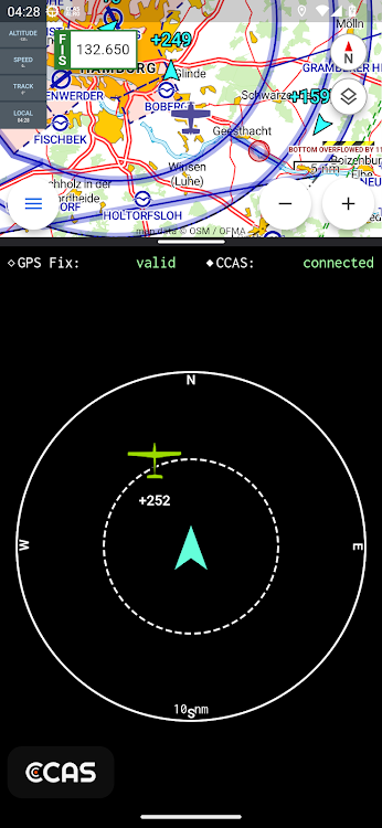
Each CCAS client periodically sends its own position to the CCAS network. On the other hand, the CCAS servers broadcast all relevant traffic around this position back to the CCAS client. By using standard TCP connections combined with a highly optimized protocol, this operates almost in real-time.
Besides other CCAS users, the server also broadcasts traffic information from different other sources, such as ADS-B, as well as OGN/FLARM, in order to have as much information as possible.
You can easily connect CCAS to your navigation app (e.g. VFRnav). This means that traffic is displayed directly on the moving map. Traffic data is transmitted via GDL90. In addition, CCAS can be used as a proxy for other traffic data sources such as Stratux, FLARM or ADS-B receivers.
- How to use -
In order to use CCAS and help increase safety in the air, simply download the official CCAS client. It's completely free by the way!
Important note on privacy: No registration is necessary. Upon the first launch of the client, a random ID is generated on the device. Every position message is sent encrypted and only provided to other users of CCAS network in immediate proximity. No flight history is saved.
- How to contribute -
Simply use the client. Every pilot using CCAS makes an important contribution to make the airspace safe.
Screenshots


What's new
- Version: 24.03.0
- Updated:
- v24.03.0
new: add own aircraft id to filter own position
new: map view added
fix: some ui improvements
breaking change: changed default port to 4000 in order to support all flight nav apps
v23.11.1
app integration fixes (SkyDemon, VFRnav, ...)
v23.04.3
attitude indicator for stratux added
new backend protocol
fix GDL90 speed value
open beta release
Price
- Today: Free
- Minimum: Free
- Maximum: Free
Track prices
Developer
- flugbetrieb.com
- Platforms: Android Apps (6)
- Lists: 0 + 0
- Points: 0 + 5,043 ¡
- Rankings: 0
- Reviews: 0
- Discounts: 0
- Videos: 1
- RSS: Subscribe
Points
Not found ☹️
Rankings
Not found ☹️
Lists
Not found ☹️
Reviews
Be the first to review!
Additional Information
- Category:
Android Apps›Maps & Navigation - OS:
Android 5.0 and up - Size:
21 Mb - Content Rating:
Everyone - Google Play Rating:
0 - Updated:
- Release Date:
Contacts
- Website:
 https://ccas.aero
You may also like
-
- VFR
- Android Apps: Maps & Navigation By: Olivier Donati
- $8.49
- Lists: 0 + 0 Rankings: 0 Reviews: 0
- Points: 0 + 0 Version: 4.1.9 This application is intended for light aircraft or gliders pilots. It provides navigation aid and moving map on android 4.1+ devices. Caution : - VFR runs much better on a device with ...
-
- VFR Map
- Android Apps: Maps & Navigation By: Stéphane Sandon
- * Free
- Lists: 0 + 0 Rankings: 0 Reviews: 0
- Points: 0 + 0 Version: 3.12.6 Hello friends VFR pilots, Thanks to VFR Map you can: - follow the position of your plane in real time on a "moving map" displaying the maps: VAC approach and landing, NAV (1: 1000000, ...
-
- myAIP VFR
- Android Apps: Maps & Navigation By: JTO
- $4.28
- Lists: 0 + 0 Rankings: 0 Reviews: 0
- Points: 0 + 10 Version: 1.73.08-full myAIP is an all-in-one application to assist plane pilots in preparing VFR flights in France and in a large part of Europe! It provides all the information and aeronautical safety for ...
-
- DailyFlightBuddy - VFR/NVFR
- Android Apps: Maps & Navigation By: Always Organized
- Free
- Lists: 0 + 0 Rankings: 0 Reviews: 0
- Points: 0 + 0 Version: 83.0.0 DailyFlightBuddy helps you navigating during the flight - VFR/NVFR From pilots - for pilots. Your personal flight planning and flight capture tool Start your flight with a few little ...
-
- GA Flight Tracker
- Android Apps: Maps & Navigation By: Oxigen Apps
- * Free
- Lists: 0 + 0 Rankings: 0 Reviews: 0
- Points: 0 + 49 Version: 4.2.2312211 VERSION 4.0 RELEASED! ** Visit our website for your interactive experience and Flight Planning ** https://www.gaflighttracker.com * Now with VFR sectional charts, obstacle avoidance ...
-
- OnCourse - boating & sailing
- Android Apps: Maps & Navigation By: MarineTraffic
- * Free
- Lists: 0 + 0 Rankings: 0 Reviews: 0
- Points: 0 + 1,885 Version: New Improve your experience at sea with OnCourse, the new boating and sailing navigation aid from MarineTraffic, the global leader in vessel tracking. OnCourse helps you stay aware of the ...
-
- SkyCharts XC EFB geo-reference
- Android Apps: Maps & Navigation By: SkyCharts LLC
- * * Free
- Lists: 0 + 0 Rankings: 0 Reviews: 0
- Points: 0 + 87 Version: 5.5.0 Current and valid FAA&AISWEB aviation charts updated every 28 days, including approach plates! Includes basic international airport data from ourairports.net and openAIP.net. Due to no
-
- DroidEFB, US Only
- Android Apps: Maps & Navigation By: DroidEFB, LLC - Aviation GPS
- * Free
- Lists: 0 + 0 Rankings: 0 Reviews: 0
- Points: 0 + 580 Version: 2.8.4 DroidEFB (single word, droid.e.f.b) is, you guessed it, an Electronic Flight Bag for Android! Developed by pilots and enhanced via user feedback, this flight planning app is designed ...
-
- Horizon Portable Glass Cockpit
- Android Apps: Maps & Navigation By: Helios Avionics GmbH
- Free
- Lists: 0 + 0 Rankings: 0 Reviews: 0
- Points: 0 + 133 Version: 3.12 A fully functional portable glass cockpit (EFIS) for general aviation pilots. It improves your flight experience, offering you intuitive visualizations for enhanced situational ...
-
- Pooleys iPlates
- Android Apps: Maps & Navigation By: Pooleys Flight Equipment Limited
- * Free
- Lists: 0 + 0 Rankings: 0 Reviews: 0
- Points: 0 + 0 Version: 1.0.6 The new Pooleys iPlates App is a completely new edition of the popular platform for digital aeronautical plate information. With a revamped user interface, the new app is easier to use
-
- EFB Pro
- Android Apps: Maps & Navigation By: Jean Knapp
- Free
- Lists: 0 + 0 Rankings: 0 Reviews: 0
- Points: 0 + 0 Version: 1.0 Introducing EFB Pro - Your Ultimate Electronic Flight Bag for Brazilian Air Space! Embark on a seamless aviation journey with EFB Pro, the must-have app designed exclusively for pilots
-
- SkyDemon
- Android Apps: Maps & Navigation By: Divelements Limited
- Free
- Lists: 0 + 0 Rankings: 0 Reviews: 0
- Points: 0 + 2,584 Version: 3.16.13 SkyDemon is one of Europe's most popular solutions for VFR flight planning and in-flight navigation. Use this app to access your SkyDemon subscription on your Android device, unlocking
-
- Galactio - Navigation & Maps
- Android Apps: Maps & Navigation By: Quantum Inventions
- * Free
- Lists: 0 + 0 Rankings: 0 Reviews: 0
- Points: 0 + 951 Version: 4.02.11 Galactio is the most advanced mobile navigation app for urban mobility. Real-time traffic updates combined with accurate maps and live traffic camera views get you to your destination ...
-
- RocketRoute FlightPlan
- Android Apps: Maps & Navigation By: RocketRoute Ltd.
- * Free
- Lists: 0 + 0 Rankings: 0 Reviews: 0
- Points: 0 + 321 Version: 7.12.0 (4145) RocketRoute combines Worldwide Flight Planning and In-Flight Navigation in one amazing Android app. Beautifully designed for pilots by pilots, with concise information, intuitive ...