| Developer: | DroidEFB, LLC - Aviation GPS (1) | ||
| Price: | * Free | ||
| Rankings: | 0 | ||
| Reviews: | 0 Write a Review | ||
| Lists: | 0 + 0 | ||
| Points: | 0 + 580 ¡ | ||
| Points + 1 | |||
Description
")
FAA Approved - Class 1 Electronic Flight Bag (EFB) - Reference AC91-78 and AIM Chapter 1
*En-route GPS navigation via moving map
*NOAA aviation weather and NEXRAD radar
*Geo-referenced approach plates and taxi diagrams
*ADS-B compatibility
*Draw on charts and approach plates
*Weight and balance
*Translated TAF and METAR
*Fuel price and FBO information
*Flight plan filing
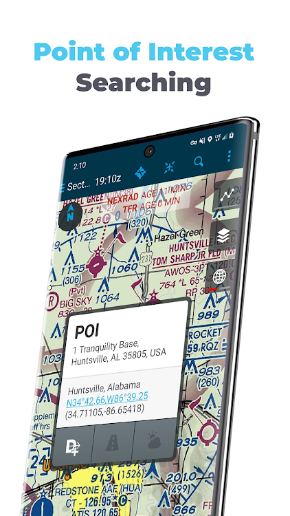
*Points of Interest (POI) search
SUBSCRIPTION OPTIONS:
30-day free trial
$6.99 per month, VFR
$74.99 per year, VFR
$149.99 per year, VFR + IFR with Geo-referenced approach plates
An Electronic Flight Bag (EFB) reduces cockpit workload and provides relevant information when you need it. DroidEFB overlays current position and flight plan onto an FAA Sectional, TAC, Low Altitude or High-Altitude chart. On the ground, current weather is displayed for long range planning; helping pilots visualize the impact current conditions will have on their flight.
Easily amend airports, waypoints, victor/jet airways, STARs, DPs, GPS coordinates and DME. Advanced navigation log takes into account current winds aloft for precise planning.
Routes flown are stored as GPS breadcrumbs and can be uploaded and viewed in Google Earth. https://droidefb.com/tutorials/
Charts and plates are viewable via our servers with an Internet connection and are downloadable for offline use. RouteMinder™ automatically checks the planned route for Charts needing downloaded.
DroidEFB can be used to receive and file official briefings! Register at www.1800wxbrief.com/Website/ and enable Avilution/DroidEFB in the list of service providers (Flight Planning & Briefing > Service Provider) to receive notifications.
DroidEFB Features:
-Point of Interest (POI) Search - find and save airports, street addresses, business names, coordinates
-Approach plates and airport diagrams (Geo-referenced with Premium subscription)
-Create, save, and sync user waypoints and Flight Plans
-NEXRAD and ADS-B traffic (TIS-B) w/supported devices
-Write or draw on charts and terminal procedures
-Arrival (STAR) and Departure (DP) procedures
-Sophisticated weight and balance
-FBO Fuel Price (100LL; Jet A)
-VSR (vertical speed required)
-Special Use Airspace (SUA)
-Store data on External SD
-A/FD (chart supplement)
-Pinch zoom and measure
-Redundant data servers
-Real-time GPS tracking
-Grand Canyon Charts
-Helicopter Charts
-Track prediction
-QuickWeather (free)
-Auto Logbook
-SAR patterns
-Track Log
Weather Overlay:
-NEXRAD (Internet, MobileLink, ADS-B)
-SIGMET / AIRMET (Internet, MobileLink)
-METAR (Internet, MobileLink, ADS-B)
-PIREP (Internet, MobileLink, ADS-B)
-TAF (Internet, MobileLink, ADS-B)
-Surface and winds aloft (Internet)
-Current Icing Potential (Internet)
-Satellite imagery (MobileLink)
-Lightning strikes (MobileLink)
-Freezing levels (MobileLink)
-NOTAMs (Internet, ADS-B)
-Area forecast (Internet)
-TFRs (Internet)
Third party devices and program support:
-Baron MobileLink
-iLevil with AHRS
-Microsoft FSX
-Dual XGPS
-ZAON XRX
-Pathfinder
-SkyRadar
-X-Plane
-Stratux
-Dynon
For pilots using phones and tablets running Android 5.1 or higher.
One subscription or free trial may be used on multiple devices such as a phone and tablet. Subscriptions authenticated using the Google account on your Android device. Password and Credit Card information are never shared with DroidEFB.
Rooted devices not "officially" supported.
We cannot respond to feedback or app issues left in Google Play reviews. For support, visit https://www.droidefb.com
Screenshots


Video
What's new
- Version: 2.8.4
- Updated:
- 2.8.4:
*Prevent login prompt if no Internet
*Prevent wrong ADSB SSID
*Enable weather imagery animations in Preferences
TIP – Track Log is automatically started and stopped based on Airborne Threshold and Landing Decision Delay setting in Preferences. Optionally, tap the Flight Timer in the Flight Plan Tab to start or stop Track Log manually.
TUTORIALS: https://droidefb.com/tutorials/
DOCUMENTATION: https://droidefb.com/documentation/
MANAGE: https://droidefb.com/manage-subscription/
Price
-
*In-App Purchases - Today: Free
- Minimum: Free
- Maximum: Free
Track prices
Developer
- DroidEFB, LLC - Aviation GPS
- Platforms: Android Apps (1)
- Lists: 0 + 0
- Points: 0 + 580 ¡
- Rankings: 0
- Reviews: 0
- Discounts: 0
- Videos: 1
- RSS: Subscribe
Points
Not found ☹️
Rankings
Not found ☹️
Lists
Not found ☹️
Reviews
Be the first to review!
Additional Information
- Category:
Android Apps›Maps & Navigation - OS:
Android 5.1 and up - Size:
22 Mb - Content Rating:
Everyone - Google Play Rating:
4.4(580) - Updated:
- Release Date:
Contacts
- Facebook: tutorials
- Website:
 https://www.droidefb.com
You may also like
-
- US Topo Maps
- Android Apps: Maps & Navigation By: ATLOGIS Geoinformatics GmbH & Co. KG
- * * Free
- Lists: 0 + 0 Rankings: 0 Reviews: 0
- Points: 0 + 9,541 Version: 7.2.2 Easy to use outdoor navigation app with free access to the best available maps and aerial imagery for the USA. Choose between 30+ map layers (topos, aerials, sea charts, ...) to plan ...
-
- Ecotoll – Pay tolls in the US
- Android Apps: Maps & Navigation By: ClearRoad
- Free
- Lists: 0 + 0 Rankings: 0 Reviews: 0
- Points: 0 + 44 Version: 1.5.3 Ecotoll is here to take care of all things tolling. Ecotoll allows you to pay for tolls* on your personal vehicle, rental cars, and motorcycles when you travel. Use the app to track ...
-
- Cng/Lpg Finder EUR&US&CAN
- Android Apps: Maps & Navigation By: Lepus
- * Free
- Lists: 0 + 0 Rankings: 0 Reviews: 0
- Points: 0 + 118 Version: 6.0.0 Cng/Lpg Finder is a route planner and a tool for finding compressed natural gas (Cng) or liquified petroleum gas (Lpg) stations along the route or around a location. Lpg and Cng ...
-
- GPS cards - for GPS Trackers
- Android Apps: Maps & Navigation By: GPS.cards
- Free
- Lists: 0 + 0 Rankings: 0 Reviews: 0
- Points: 0 + 23 Version: 2.17.4.4674 GPS.cards mobile app is for Real-Time tracking your fleet GPS Tracker, whether it be one or several hundred. We ve curated a professional easy to use app for easily tracking and ...
-
- AvNav EFB
- Android Apps: Maps & Navigation By: AvNav, LLC
- Free
- Lists: 0 + 0 Rankings: 0 Reviews: 0
- Points: 0 + 333 Version: 5.2.5-prod The Most Advanced Flight Planning and Navigation App for Pilots on Android. AvNav is for pilots who enjoy local and cross country flying through variety of terrain and weather ...
-
- Black & White Transportation
- Android Apps: Maps & Navigation By: Black & White Design, LLC.
- Free
- Lists: 0 + 0 Rankings: 0 Reviews: 0
- Points: 0 + 86 Version: 13.10.0 Book a taxi in under 10 seconds and experience exclusive priority service from Black & White Transportation You can place the booking directly on our map, and see how many available ...
-
- Community Transit Bus - MonTr…
- Android Apps: Maps & Navigation By: MTransit Apps
- Free
- Lists: 0 + 0 Rankings: 0 Reviews: 0
- Points: 0 + 17 Version: 24.04.16r1389 This app adds Snohomish County Community Transit buses information to MonTransit. This app provides the buses schedule as well as the latest news from communitytransit.blogspot.com and
-
- SG BusLeh: Award Winning
- Android Apps: Maps & Navigation By: OriginallyUS.SG - Award Winning App Consultancy
- * * Free
- Lists: 0 + 0 Rankings: 0 Reviews: 0
- Points: 0 + 13,785 Version: 2.4.7 A SG Bus Arrival App for both SBS and SMRT bus arrival timing that Singapore Truly Deserves! SG BusLeh won LTA's Land Transport Excellence Awards 2016 - Most Innovative Solution! ...
-
- Operr Driver
- Android Apps: Maps & Navigation By: Operr Technologies
- Free
- Lists: 0 + 0 Rankings: 0 Reviews: 0
- Points: 0 + 16 Version: 4.15.11 Download and start working trips assigned to you Do trip attestations right from your phone Reminders and alerts help you stay compliant Customize zones where you want or dont want to ...
-
- accugps
- Android Apps: Maps & Navigation By: JY Joint
- Free
- Lists: 0 + 0 Rankings: 0 Reviews: 0
- Points: 0 + 36 Version: 3.0.4 Access all the key functionality of your AccuGPS GPS tracking account at any time, and from any location using this AccuGPS Mobile App for Android. AccuGPS's mobile app enables users ...
-
- GPS Tracker: Family locator
- Android Apps: Maps & Navigation By: The Office Tool Mobie
- * * Free
- Lists: 0 + 0 Rankings: 0 Reviews: 0
- Points: 0 + 1,080 Version: 26.8 GPS Tracker: GPS Phone locator app is for you! Our phone tracker app helps you to track device and find your location at all times. GPS Tracker is a real-time location tracking app, ...
-
- FlightIntel
- Android Apps: Maps & Navigation By: Nadeem Hasan
- Free
- Lists: 0 + 0 Rankings: 0 Reviews: 0
- Points: 0 + 504 Version: 6.30.7 US AIRPORTS ONLY. FlightIntel is designed to be a resource to a pilot during all phases of a flight. It provides detailed information about 5500+ US public airports. AF/D data is ...
-
- Scout Maps & Safer Navigation
- Android Apps: Maps & Navigation By: Telenav, Inc.
- * Free
- Lists: 0 + 1 Rankings: 0 Reviews: 0
- Points: 0 + 121,305 Version: New Introducing Scout Maps: Your Trusted Co-Pilot, Safety Coach, and Personal Driver Assistant! Scout Maps is redefining what it means to drive smarter and safer on the road with ...
-
- Minnesota State Fair Map Guide
- Android Apps: Maps & Navigation By: GeoPOI LLC
- $0.49
- Lists: 0 + 0 Rankings: 0 Reviews: 0
- Points: 0 + 18 Version: 1.0.1 This is your ticket to navigating the chaos of the Minnesota State Fair with ease! It allows users to see the locations and details of over 1000 food and merchandise vendors in an ...