| Developer: | Imray (5) | ||
| Price: | $4.99 | ||
| Rankings: | 0 | ||
| Reviews: | 0 Write a Review | ||
| Lists: | 0 + 0 | ||
| Points: | 0 + 3 ¡ | ||
| Points + 1 | |||
Description
")
INCLUDES
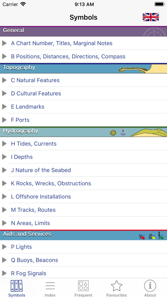
- Comprehensive coverage: more than 800 symbols and abbreviations.
- Full content tree, organised for ease of use.
- Index and grouped index for all entries.
- Search facility.
- Sample chart with visual popups for commonly used symbols.
- Favourites: archive your best symbols.
- Multi-language within the app (English/French).
Full international standard from the IHO.All topics from the IHO, UKHO, SHOM, NOAA, CHS and other hydrographic offices:
position, distance, direction, compass, features, landmarks, ports, tides, currents, seabed, rocks, wrecks, obstructions, offshore, tracks, routes, areas, limits, lights, buoys, beacons, fog, radar, radio, services, small craft.
LANGUAGES
English, French, German, Italian, Spanish
ABOUT US
Imray are a leading chart and marine book publishers, based in England and with a catalogue of charts for Europe, the Mediterranean and the Caribbean. Imray's pilot books cover the whole world in extensive detail.
In partnership with Imray, software developers and sailors.
Follow us on Twitter - http://twitter.com/imray_charts
Facebook - imraynautical
Look out for other applications in the Marine Navigation Series from Imray:
TIDES PLANNER - tide predictions any date
RULES & SIGNALS- Rule of the Road, signals at sea.
RACING RULES - RYA Handy Guide to rules for sailing races
Screenshots


What's new
- Version: 2.1.0
- Updated:
- • iOS13 compatibility including dark mode.
Price
- Today: $4.99
- Minimum: $4.99
- Maximum: $4.99
Track prices
Developer
Points
Not found ☹️
Rankings
Not found ☹️
Lists
Not found ☹️
Reviews
Be the first to review!
Additional Information
Contacts
- X: imray_charts
- Website:
 http://www.imray.com
You may also like
-
- Marine Navigation Lite
- iOS Apps: Navigation By: Marco Palaferri
- * Free
- Lists: 0 + 0 Rankings: 0 Reviews: 0
- Points: 0 + 2 Version: 9.3.1 MARINE NAVIGATION Find your road on the sea! GPS chartplotter for boating. An easy-to-use offline GPS tracker and route planner featuring worldwide offline maps. Navigate with your ...
-
- Marine Radar
- iOS Apps: Navigation By: 株式会社フルノソフテック
- Free
- Lists: 0 + 0 Rankings: 0 Reviews: 0
- Points: 1 + 11 Version: 2.1.3 Descriptions: This Marine Radar App, in connection with the Furuno Wireless Radar Sensor DRS4W, enables to view and control Radar images on iOS devices. How to use: Get the Marine ...
-
- Marine Compass Pro
- iOS Apps: Navigation By: DF Tech Consulting AB
- $1.99
- Lists: 0 + 0 Rankings: 0 Reviews: 0
- Points: 2 + 0 Version: 1.1.7 Navigate the open waters with confidence using Marine Compass, your ultimate boating companion. Get real-time information on your heading, speed in knots, latitude, and longitude. Set ...
-
- onNAV Marine
- iOS Apps: Navigation By: onNAV LLC
- * Free
- Lists: 0 + 0 Rankings: 0 Reviews: 0
- Points: 0 + 8 Version: 1.0.7 onNAV Marine is an essential tool for any boater. Its next generation Anchor Alert, 3D ENC charts, and user-friendly interface make it the perfect companion for any trip on the water. ...
-
- TZ iBoat – Marine Navigation
- iOS Apps: Navigation By: Nobeltec, Inc.
- * Free
- Lists: 0 + 0 Rankings: 0 Reviews: 0
- Points: 0 + 490 Version: 3.0.9 Navigate the seas with the most complete marine charts for coastal boating, sailing, and fishing with or without internet. GPS, anchoring, radar, AIS, tides & tidal currents... This ...
-
- WinGPS Marine
- iOS Apps: Navigation By: Stentec Software
- Free
- Lists: 0 + 0 Rankings: 0 Reviews: 0
- Points: 0 + 3 Version: 1.27 Ideal for navigation onboard of your sailing yacht, motorship, canoe or longboat: - Always know where you are, how fast you go and what your course is using a GPS receiver (internal or
-
- iNavX: Marine Navigation
- iOS Apps: Navigation By: NavX Studios LLC
- * Free
- Lists: 0 + 0 Rankings: 0 Reviews: 0
- Points: 7 + 18,519 Version: 5.6.32 Marine navigation is made easy with iNavX - the world's #1 handheld Chartplotter. Access marine charts, maps, weather, AIS and more! iNavX is the only app to give you complete ...
-
- mKart Marine Navigation
- iOS Apps: Navigation By: GEOPHONE GROUP INTERNATIONAL Oy
- Free
- Lists: 0 + 0 Rankings: 0 Reviews: 0
- Points: 1 + 3 Version: 1.8.727 mKart 3D marine App is for safe and comfortable navigation. Product Highlights: WEB CONSOLE: E-shop; ENCs and cartographic products Catalogue; Portfolio optimization; Fleet management;
-
- i-Boating: Marine Charts & Gps
- iOS Apps: Navigation By: Bist LLC
- * Free
- Lists: 0 + 0 Rankings: 0 Reviews: 0
- Points: 0 + 11,063 Version: 141.0.0 This App offers access to Marine Charts for USA,Canada,UK/Ireland,Germany,Netherlands/Holland & Europe Rivers (Danube,Drava,Rhein etc). Coverage includes NOAA marine vector ...
-
- PRO CHARTS - Marine Navigation
- iOS Apps: Navigation By: MiraTrex, Inc.
- Free
- Lists: 0 + 0 Rankings: 0 Reviews: 0
- Points: 0 + 7,912 Version: 5.70 MiraTrex PRO CHARTS™ is a powerful, yet easy-to-use marine navigation system. Whether you re a fisherman, weekend cruiser, sailor, diver, jet-skier, or an offshore captain needing to ...
-
- Wavve Boating: Marine Boat GPS
- iOS Apps: Navigation By: Wavve Boating INC
- * Free
- Lists: 0 + 0 Rankings: 0 Reviews: 0
- Points: 0 + 1,676 Version: 4.9.5 Ever have a stressful day navigating on the water? Wanted to know more about the conditions you are about to head into? Are you looking for exciting places to explore, the best place ...
-
- AIS Maps: Marine & Lake charts
- iOS Apps: Navigation By: Flytomap
- * Free
- Lists: 0 + 0 Rankings: 0 Reviews: 0
- Points: 0 + 36 Version: 6.4.0 Discover a new perspective on the world with AIS Maps: Marine and Lakes Charts by FlyToMap. Our app is meticulously crafted, offering a seamless blend of aesthetic appeal and ...
-
- SafePilot by Trelleborg
- iOS Apps: Navigation By: Trelleborg Marine Systems Denmark A/S
- Free
- Lists: 0 + 0 Rankings: 0 Reviews: 0
- Points: 1 + 4 Version: 24.1 SafePilot is the new generation of professional maritime piloting software from Trelleborg. It is designed by a dedicated group of software developers and active maritime pilots. The ...
-
- eSeaGo
- iOS Apps: Navigation By: Hydrographic Office of Marine Department of the Government of HKSAR
- Free
- Lists: 0 + 0 Rankings: 0 Reviews: 0
- Points: 1 + 3 Version: 5.0.27 The "eSeaGo" is a free mobile application that offers a simple and convenient solution for displaying chart information for Hong Kong waters. Through the "eSeaGo", users can download ...