| Developer: | Marco Palaferri (8) | ||
| Price: | * Free | ||
| Rankings: | 0 | ||
| Reviews: | 0 Write a Review | ||
| Lists: | 0 + 0 | ||
| Points: | 0 + 2 ¡ | ||
| Points + 1 | |||
Description
")
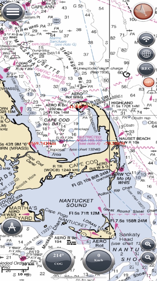
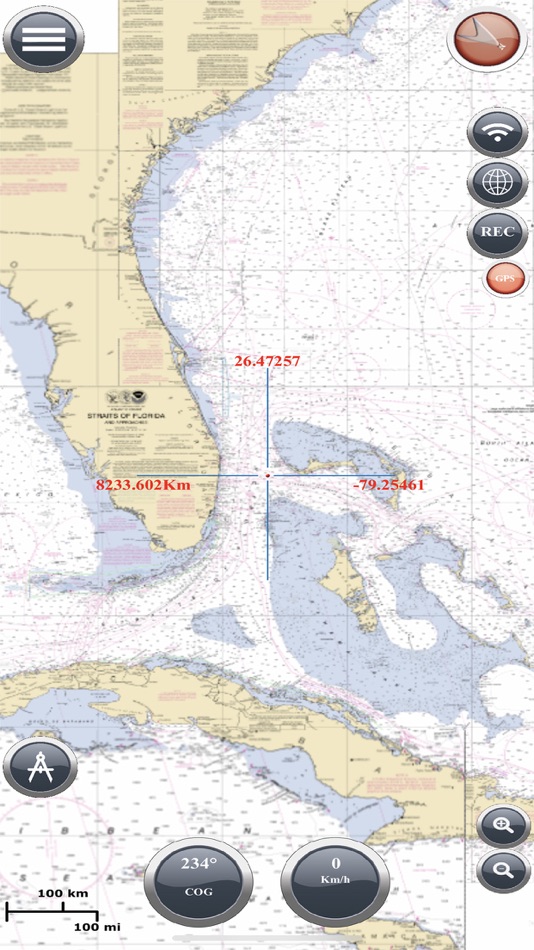
Find your road on the sea! GPS chartplotter for boating.
An easy-to-use offline GPS tracker and route planner featuring worldwide offline maps.
Navigate with your favorite device around the world, turn your smartphone or tablet into a GPS navigator with an offline map, ideal for sea, rivers and lakes, for boaters, fishermen and water sports.
This application is dedicated to the sea and the people who love it and live it with passion.
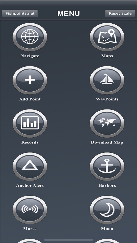
WHAT MAKES IT A BEST GPS TRACKER OR NAVIGATOR
Offline GPS tracker for boat navigation. GPS Chartplotter for Sailing & boating.
Morse Code in case of danger, Anchor Alert to prevent the drift of the anchor, Weather and Moon Phase to show the forecast during the day, Harbors to see the list of ports, Sync Waypoints to be able to create backups and access them from different devices.
You also get to download the maps and marine charts, so you won’t need an active internet connection when it comes to getting navigation and route planning. If you create a profile, you can save waypoints and routes to access them from different devices. All you have to do is logging in with the same account and enjoy seamless sea GPS navigations.
So, no matter you are a professional sailor or fisherman, or you are an amateur who like traveling in the sea, Marine Navigation has got you covered. It’s a versatile sea navigator app and boating route planner which provides accurate GPS Chartplotter and marine charts.
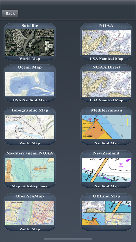
MAPS OFFLINE:
Download maps or marine charts, you need a select area and application save tile into your device. Navigate on preloaded maps without connection.
MAPS AND MARINE CHARTS:
MapView: http://www.fishpoints.net/mapsview/
•Nautical maps of the United States of America by NOAA
•Nautical maps of the Mediterranean by NOAA
•Mediterranean RNC
•Nautical maps of the NewZealand by LINZ
•Maps of the world’s oceans and coastal areas by ESRI
•World topographic map includes boundaries, cities, water features, ports, physiographic features by ESRI
•Satellite imagery for the world by ESRI
•Maps for the sea, with ports, sea light and more by Open Sea Map
Marine Navigation: GPS Tracker Main Features at a Glance
•Super easy to use GPS tracker tool
•Clean and neat design
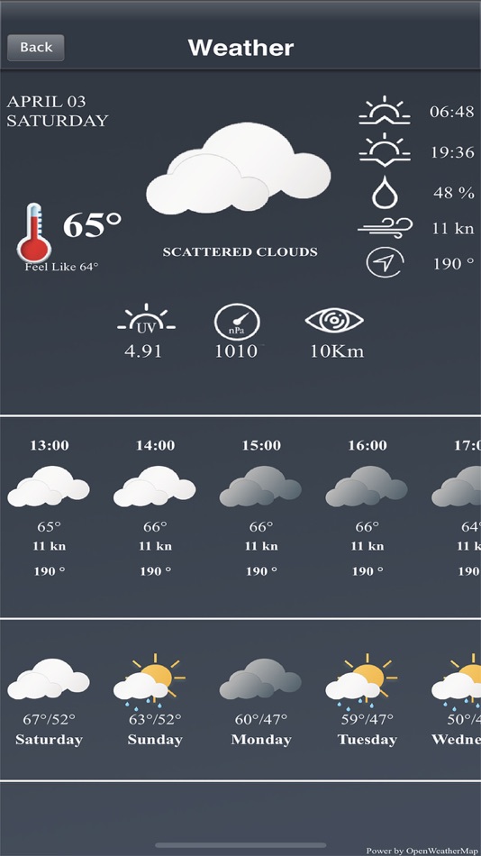
•Weather
•GPX Import & Export
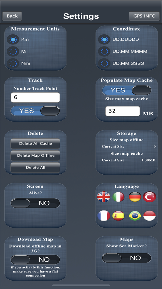
•Available in different languages: English, Italian, French, Spanish, Brazilian, Turkish and German,Indonesian
•Download Maps to use in offline mode
•Accurate and detailed GPS Chartplotter, GPS plotter and Marine charts
•Optimized for phones and tablets
•Moon phase
•Morse Code
•Receive information about speed, direction, time to arrival
•Compass Magnetic or True
•Change Measurement Units: Km, Mi, or Nmi
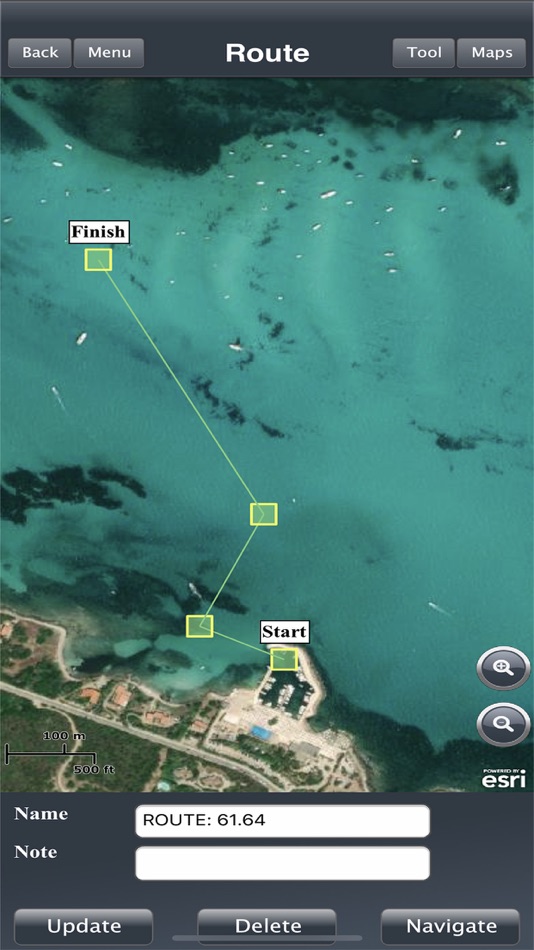
•Record your route for analyze the data and navigate again
LOCATION PERMISSION
Location information is processed locally on your device, ensuring your privacy.
HELP US
Download Marine Navigation and let us know about any bugs, feature requests or any other suggestions. Stay tuned for more features and options in this GPS tracker app for boating.
WARNING
Good seamanship requires the use of official charts. Marine Navigation is for use with other charts and cannot replace official charts. Use at your own risk.
LEARN MORE ABOUT FISHPOINTS
http://www.fishpoints.net
IMPORTANT INFORMATION ABOUT SUBSCRIPTIONS
Payment: will be charged to iTunes Account at confirmation of purchase.
Subscription: is automatically renewed on the same account, unless the automatic renewal is deactivated at least 24 hours before the end of the current period.
Manage Subscription: auto-renewal may be turned off by going to the user's Account Itunes Settings after purchase.
A link to the terms of use: http://www.fishpoints.net/eula/
A link to the privacy policy: http://www.fishpoints.net/privacy-policy
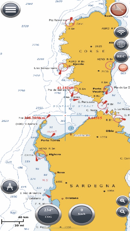
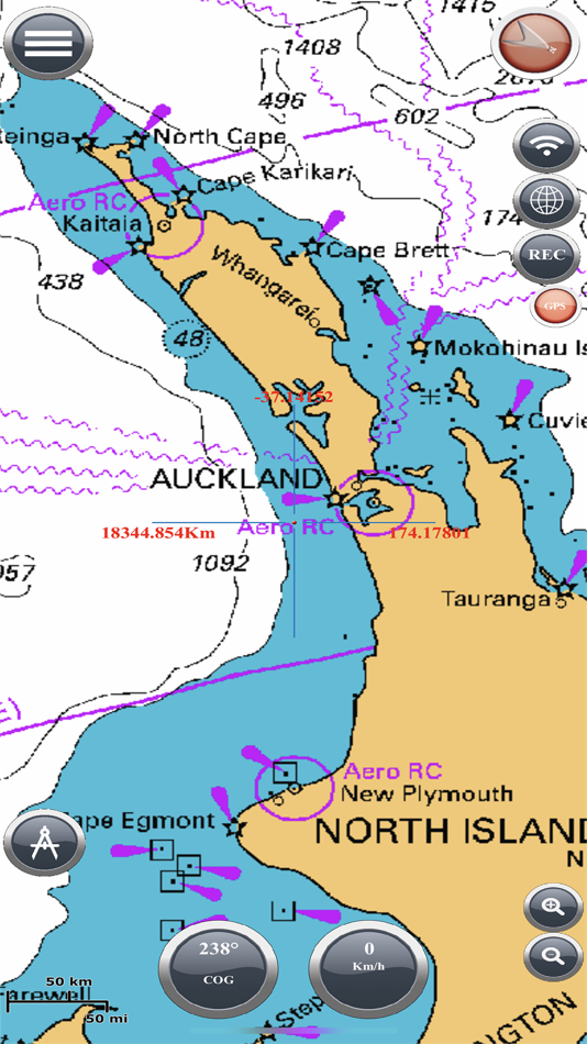
Screenshots

What's new
- Version: 9.3.1
- Updated:
- Upload new integration of ESRI MAPS
Price
-
*In-App Purchases - Today: Free
- Minimum: Free
- Maximum: Free
Track prices
Developer
- Marco Palaferri
- Platforms: Android Apps (4) iOS Apps (4)
- Lists: 0 + 0
- Points: 1 + 2,765 ¡
- Rankings: 0
- Reviews: 0
- Discounts: 0
- Videos: 2
- RSS: Subscribe
Points
Not found ☹️
Rankings
Not found ☹️
Lists
Not found ☹️
Reviews
Be the first to review!
Additional Information
- Category:
iOS Apps›Navigation - OS:
iPad,iPhone,iOS 11.0 and up - Size:
63 Mb - Supported Languages:
Chinese,Czech,Danish,Dutch,English,Finnish,French,German,Greek,Hebrew,Indonesian,Italian,Japanese,Korean,Malay,Norwegian,Polish,Portuguese,Russian,Spanish,Swedish,Thai,Turkish,Vietnamese - Content Rating:
17+ - App Store Rating:
3.0(2) - Updated:
- Release Date:
Contacts
- Website:
 http://www.fishpoints.net
You may also like
-
- iNavX: Marine Navigation
- iOS Apps: Navigation By: NavX Studios LLC
- * Free
- Lists: 0 + 0 Rankings: 0 Reviews: 0
- Points: 7 + 18,519 Version: 5.6.32 Marine navigation is made easy with iNavX - the world's #1 handheld Chartplotter. Access marine charts, maps, weather, AIS and more! iNavX is the only app to give you complete ...
-
- PRO CHARTS - Marine Navigation
- iOS Apps: Navigation By: MiraTrex, Inc.
- Free
- Lists: 0 + 0 Rankings: 0 Reviews: 0
- Points: 0 + 7,912 Version: 5.70 MiraTrex PRO CHARTS™ is a powerful, yet easy-to-use marine navigation system. Whether you re a fisherman, weekend cruiser, sailor, diver, jet-skier, or an offshore captain needing to ...
-
- mKart Marine Navigation
- iOS Apps: Navigation By: GEOPHONE GROUP INTERNATIONAL Oy
- Free
- Lists: 0 + 0 Rankings: 0 Reviews: 0
- Points: 1 + 3 Version: 1.8.727 mKart 3D marine App is for safe and comfortable navigation. Product Highlights: WEB CONSOLE: E-shop; ENCs and cartographic products Catalogue; Portfolio optimization; Fleet management;
-
- TZ iBoat – Marine Navigation
- iOS Apps: Navigation By: Nobeltec, Inc.
- * Free
- Lists: 0 + 0 Rankings: 0 Reviews: 0
- Points: 0 + 490 Version: 3.0.9 Navigate the seas with the most complete marine charts for coastal boating, sailing, and fishing with or without internet. GPS, anchoring, radar, AIS, tides & tidal currents... This ...
-
- Marine Compass Pro
- iOS Apps: Navigation By: DF Tech Consulting AB
- $1.99
- Lists: 0 + 0 Rankings: 0 Reviews: 0
- Points: 2 + 0 Version: 1.1.7 Navigate the open waters with confidence using Marine Compass, your ultimate boating companion. Get real-time information on your heading, speed in knots, latitude, and longitude. Set ...
-
- Marine Radar
- iOS Apps: Navigation By: 株式会社フルノソフテック
- Free
- Lists: 0 + 0 Rankings: 0 Reviews: 0
- Points: 1 + 11 Version: 2.1.3 Descriptions: This Marine Radar App, in connection with the Furuno Wireless Radar Sensor DRS4W, enables to view and control Radar images on iOS devices. How to use: Get the Marine ...
-
- i-Boating: Marine Charts & Gps
- iOS Apps: Navigation By: Bist LLC
- * Free
- Lists: 0 + 0 Rankings: 0 Reviews: 0
- Points: 0 + 11,063 Version: 141.0.0 This App offers access to Marine Charts for USA,Canada,UK/Ireland,Germany,Netherlands/Holland & Europe Rivers (Danube,Drava,Rhein etc). Coverage includes NOAA marine vector ...
-
- Wavve Boating: Marine Boat GPS
- iOS Apps: Navigation By: Wavve Boating INC
- * Free
- Lists: 0 + 0 Rankings: 0 Reviews: 0
- Points: 0 + 1,676 Version: 4.9.5 Ever have a stressful day navigating on the water? Wanted to know more about the conditions you are about to head into? Are you looking for exciting places to explore, the best place ...
-
- savvy navvy: Boat Navigation
- iOS Apps: Navigation By: savvy navvy
- * Free
- Lists: 0 + 0 Rankings: 0 Reviews: 0
- Points: 0 + 5,323 Version: 2.2.11779 Everything you need to get out on the water, if you are a boater, sailor, paddleboarder, Jet skier, Kayaker or just going fishing, we ve got you covered. Free Features - All USA ...
-
- Seawell Navigation Charts
- iOS Apps: Navigation By: seawellsoft
- Free
- Lists: 0 + 0 Rankings: 0 Reviews: 0
- Points: 1 + 11 Version: 1.5.1 Seawell marine navigation apps provide maps to make life easier and more enjoyable for sailors, fishermen, divers, boaters, and cruisers. Ability to Zoom and Pan: Our ZAP has a new ...
-
- WinGPS Marine
- iOS Apps: Navigation By: Stentec Software
- Free
- Lists: 0 + 0 Rankings: 0 Reviews: 0
- Points: 0 + 3 Version: 1.27 Ideal for navigation onboard of your sailing yacht, motorship, canoe or longboat: - Always know where you are, how fast you go and what your course is using a GPS receiver (internal or
-
- onNAV Marine
- iOS Apps: Navigation By: onNAV LLC
- * Free
- Lists: 0 + 0 Rankings: 0 Reviews: 0
- Points: 0 + 8 Version: 1.0.7 onNAV Marine is an essential tool for any boater. Its next generation Anchor Alert, 3D ENC charts, and user-friendly interface make it the perfect companion for any trip on the water. ...
-
- AIS Maps: Marine & Lake charts
- iOS Apps: Navigation By: Flytomap
- * Free
- Lists: 0 + 0 Rankings: 0 Reviews: 0
- Points: 0 + 36 Version: 6.4.0 Discover a new perspective on the world with AIS Maps: Marine and Lakes Charts by FlyToMap. Our app is meticulously crafted, offering a seamless blend of aesthetic appeal and ...
-
- NV Charts GPS Navigation AIS
- iOS Apps: Navigation By: NV Chart Group GmbH
- Free
- Lists: 0 + 0 Rankings: 0 Reviews: 0
- Points: 0 + 71 Version: 2.709.182 A clearly structured navigation app with intuitive and comprehensive tools for navigation on board. All current editions of the boating charts or maps from NV Verlag / NV Charts can be