| ผู้พัฒนา: | Lim Geomatics Inc. (6) | ||
| ราคา: | ฟรี | ||
| การจัดอันดับ: | 0 | ||
| ความเห็น: | 0 เขียนความเห็น | ||
| รายการ: | 0 + 0 | ||
| แต้มแล: | 0 + 0 ¡ | ||
| แต้มแล + 1 | |||
คำอธิบาย
")
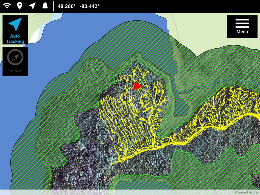
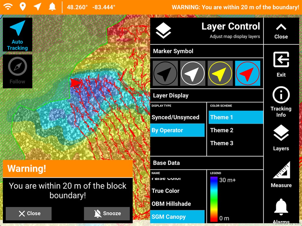
Operational Tracker is a simple, turnkey GIS solution to help you track harvesting equipment – feller bunchers, forwarders, harvesters, and skidders – in real-time, and use this information to monitor and quantify equipment performance and productivity. In addition, you can avoid trespasses with warnings sent to you well before you’re too close to a boundary.
With the Operational Tracker on hand, not only will you have a competitive edge in the forest industry, your equipment operators also benefit by having corporate GIS data at their fingertips to enable them to do their work better and faster, while remaining safe and compliant.
How Operational Tracker benefits you
With Operational Tracker, you can get updates that identify productivity and efficiency of your harvesting equipment. No longer will your forest managers need to estimate where the equipment has been or how productive they were – our app does this for you. In fact, Operational Tracker empowers you to see how you are doing, so you can get your job done more efficiently.
Through the power of an iOS, Android or Windows tablet and proprietary Lim Geomatics algorithms, Operational Tracker™ can report on productive machine hours and a wide range of productivity statistics. For operations that require precise navigation, Operational Tracker™ can be paired with an external GNSS device to pinpoint the position of machinery with an accuracy of 50 cm, even while under forest canopy.
ภาพหน้าจอ

มีอะไรใหม่
- เวอร์ชัน: PC
- อัปเดต:
ราคา
- วันนี้: ฟรี
- ต่ำสุด: ฟรี
- มากที่สุด: ฟรี
ติดตามราคา
ผู้พัฒนา
- Lim Geomatics Inc.
- แพลตฟอร์ม: Android แอป (2) iOS แอป (2) Windows แอป (2)
- รายการ: 0 + 0
- แต้มแล: 0 + 2 ¡
- การจัดอันดับ: 0
- ความเห็น: 0
- ลดราคา: 0
- วิดีโอ: 0
- RSS: ติดตาม
แต้มแล
ไม่พบ ☹️
การจัดอันดับ
ไม่พบ ☹️
รายการ
ไม่พบ ☹️
ความเห็น
แสดงรีวิวเป็นคนแรกเลย!
ข้อมูลเพิ่มเติม
- หมวดหมู่:
Windows แอป›การนำทางและแผนที่ - ระบบปฏิบัติการ:
PC - ขนาด:
60 Mb - ภาษาที่สนับสนุน:
Arabic,Bosnian,Bulgarian,Catalan,Chinese,Croatian,Czech,Danish,Dutch,English,Estonian,Finnish,French,German,Greek,Hebrew,Hungarian,Indonesian,Italian,Japanese,Korean,Latvian,Lithuanian,Norwegian,Polish,Portuguese,Romanian,Russian,Slovak,Slovenian,Spanish,Swedish,Thai,Turkish,Ukrainian,Vietnamese - การจัดประเภทเนื้อหา:
EVERYONE - Windows Store คะแนนโดย:
0 - อัปเดต:
- วันที่วางจำหน่าย:
รายชื่อติดต่อ
- เว็บไซท์:
 http://www.limgeomatics.com
คุณอาจชอบ
-
- Distance Tracker
- Windows แอป: การนำทางและแผนที่ โดย: vixezApps
- $0.99
- รายการ: 0 + 0 การจัดอันดับ: 0 ความเห็น: 0
- แต้มแล: 0 + 1 เวอร์ชัน: PC Want to track a walk, bike ride, car ride, ... ? Then Distance Tracker is exactly what you need. Easily track distances you travel, even when the app is minimized. Distance Tracker ...
-
- Irish Transport Tracker
- Windows แอป: การนำทางและแผนที่ โดย: CianG
- ฟรี
- รายการ: 0 + 0 การจัดอันดับ: 0 ความเห็น: 0
- แต้มแล: 0 + 0 เวอร์ชัน: PC Allows the user to access the TFI API in a user-friendly interface. Users can add Bus Éireann, Expressway, Dublin Bus, Iarnród Éireann and Luas stations/stops to the application.
-
- Outdoor Tracker
- Windows แอป: การนำทางและแผนที่ โดย: mjr
- ฟรี
- รายการ: 0 + 0 การจัดอันดับ: 0 ความเห็น: 0
- แต้มแล: 0 + 2 เวอร์ชัน: PC Display your current location on a map, record a track while you are walking or plan your trek and import it into the application. You can import and export your tracks as GPX or KML ...
-
- Varen Zuid Holland
- Windows แอป: การนำทางและแผนที่ โดย: Teqplay BV
- ฟรี
- รายการ: 0 + 0 การจัดอันดับ: 0 ความเห็น: 0
- แต้มแล: 0 + 0 เวอร์ชัน: PC De app VarenZH van de provincie Zuid-Holland is een navigator voor de provinciale vaarwegen in Zuid-Holland. In één oogopslag vindt u openingstijden van bruggen en sluizen in de ...
-
- SatelliteMap
- Windows แอป: การนำทางและแผนที่ โดย: KingBTC
- $4.99
- รายการ: 0 + 0 การจัดอันดับ: 0 ความเห็น: 0
- แต้มแล: 0 + 0 เวอร์ชัน: PC This application was developed by Esrishichina in shanghai, china using the lastest release of the ArcGIS Runtime100.1 for UWP. The 3d view displays approximately 1,250 satelites in ...
-
- ExplorOz Traveller
- Windows แอป: การนำทางและแผนที่ โดย: I.T. Beyond Pty Ltd
- * $39.99
- รายการ: 0 + 0 การจัดอันดับ: 0 ความเห็น: 0
- แต้มแล: 0 + 5 เวอร์ชัน: PC ExplorOz Traveller is the premier travel planner and navigation tool for your ultimate Australian adventure. Whether you're planning a road trip, venturing off-road, or free camping in
-
- QuoVadis Mobile 3
- Windows แอป: การนำทางและแผนที่ โดย: QuoVadis Software GmbH
- ฟรี
- รายการ: 0 + 0 การจัดอันดับ: 0 ความเห็น: 0
- แต้มแล: 0 + 0 เวอร์ชัน: PC ++ for a short time free of charge ++ QuoVadis Mobile is your "all-inclusive app" when it comes to navigation, GPS and maps. On-Road, Off-Road, walking, by bike or car, always with you
-
- Gps InterLink
- Windows แอป: การนำทางและแผนที่ โดย: Vanis Ltd
- ฟรี
- รายการ: 0 + 0 การจัดอันดับ: 0 ความเห็น: 0
- แต้มแล: 0 + 0 เวอร์ชัน: PC GPS InterLink mobile app turns your smartphone into a GPS tracker that displays a street map. This app exchanges data with other Gps InterLink apps and gps trackers using the Vanis Web