| ผู้พัฒนา: | Bist LLC (29) | ||
| ราคา: | * ฟรี | ||
| การจัดอันดับ: | 0 | ||
| ความเห็น: | 0 เขียนความเห็น | ||
| รายการ: | 0 + 0 | ||
| แต้มแล: | 0 + 25 ¡ | ||
| แต้มแล + 1 | |||
คำอธิบาย
")
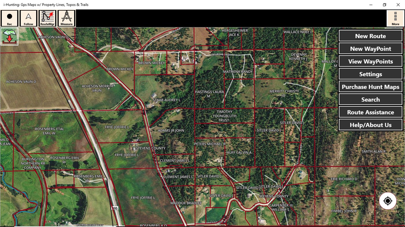
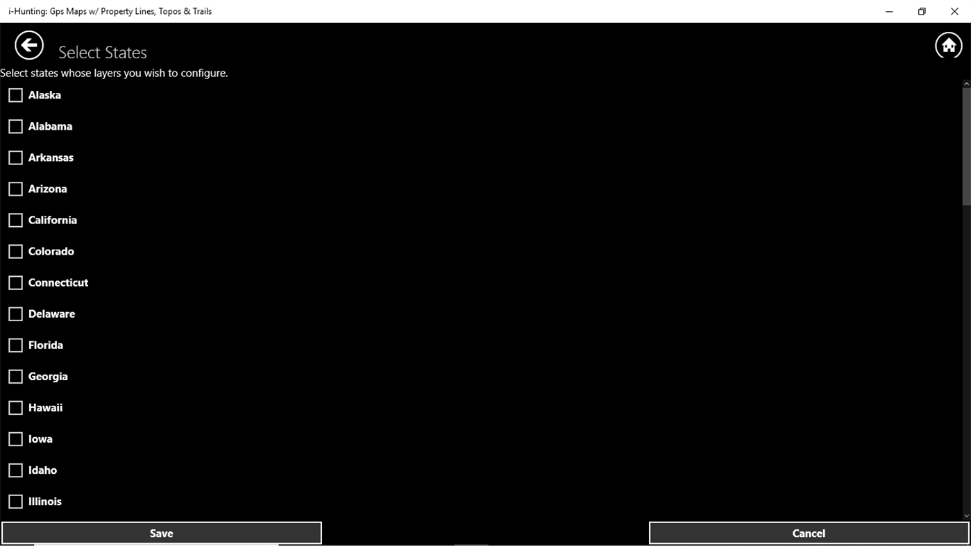
lands, land ownership details. Map layers for 50+ states include hunting
zones, restricted areas, possible access areas, state refgues and more.
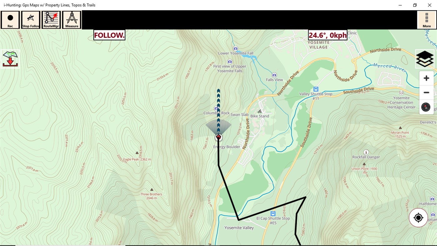
Vector topo maps with most accurate USGS elevation contours, hiking & biking
trails. Coverage includes all US states.
► Vector Topo Maps
√ Beautiful & detailed Hardware/GPU accelerated vector maps (text stays upright on rotation)
√ Vector USGS contours (Change height to ft or meter).
√ Covers popular hiking & biking trails and paths
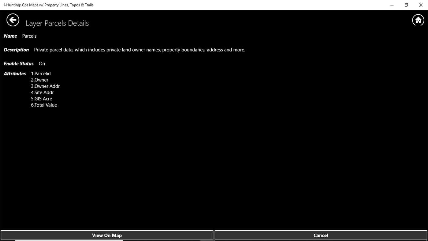
► Parcel Maps
√ Includes following ownerhsip attributes (where available)
* Owner name and Owner address
* Site Address
* Parcel ID Total Value
► Hunt Planning maps
√ Possible Public Access
√ Public lands and Parcels
√ Hunting Zones
√ Game Distribution
√ Restricted Ares
√ Portions
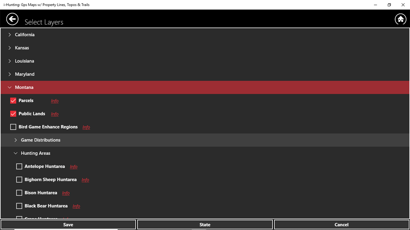
► Offline vector maps
√ Easy to download offline topos
► PLSS maps
√ PLSS Townships and Sections (US Wide coverage)
► Custom base maps
√ Switch base maps between vector topos, hybrid satellite imagery and more
►GPS FEATURES
√ Record Tracks
√ Enter or import Waypoints.
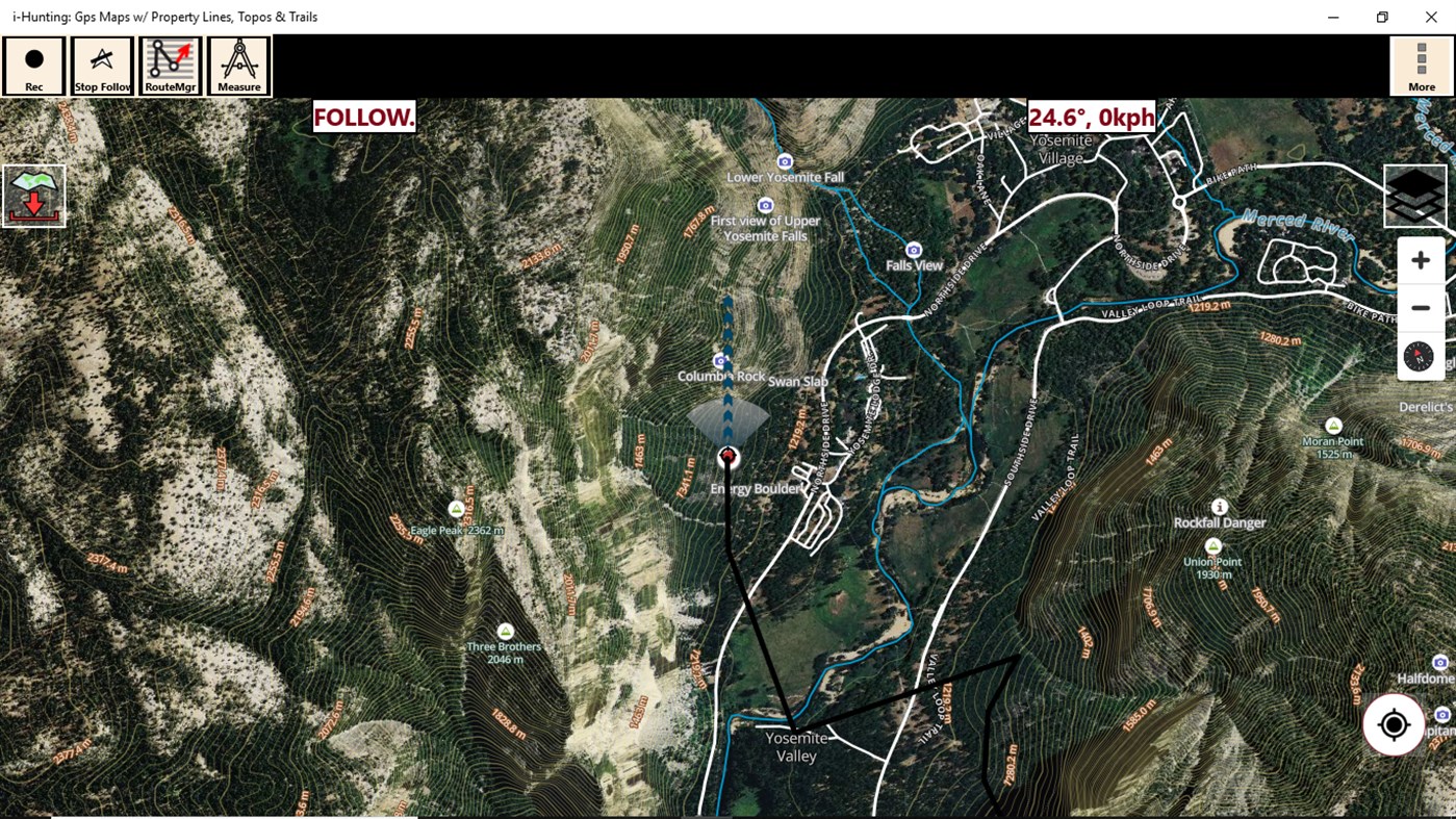
√ Auto Follow
* Real Time Track Overlay
* Predicted Path Vector
* Course Up(Text stays upright)
* Speed & Heading
√ Route Assistance With Voice Prompts
* Prompts when approaching a boating route marker
* Continous distance & ETA updates
* Alerts when off route
* Alerts when moving in wrong direction
►ROUTE MANAGEMENT / TRIP PLANNING
√ Create New Route/Edit Existing Routes
√ Move Points
√ Add points to an existing route leg
√ Delete / Rename points
√ Import GPX,KML & KMZ files
√ Plot/Edit Routes
√ Enter Waypoints
√ Share/Export Routes,Tracks&Markers
√ Reverse Routes
► SHARING
* Share tracks/routes/markers on Facebook & Twitter
* Export tracks/routes/markers as compressed GPX files.
► Topo & Trail Maps for National Parks
Detailed topographic trail maps are included for national and state park including::
√ Great Smoky Mountains
√ Grand Canyon
√ Zion
√ Rocky Mountain
√ Yosemite
√ Yellowstone
√ Acadia
√ Olympic
√ Denali
√ Glacier
► Suggested Uses for i-Hunting Topo Maps
√ Hunt Planning & Recon
√ Off trail and On trail hiking
√ Backpacking : Use Topos of National Forests and Wilderness areas with GPS
√ Snow Sports (Snow Shoeing, Skiing, Snowboarding, Snow Mobiling)
√ SAR (Search and Rescue)
The i-Hunting application can turn your phone into full fledged outdoors GPS unit (like Garmin ® or Magellan ® outddor GPS). The app compliments the gear you got from Dick's ® , REI ® , Cabelas ® etc.
ภาพหน้าจอ
มีอะไรใหม่
- เวอร์ชัน: PC
- อัปเดต:
ราคา
-
*การซื้อภายในแอพ - วันนี้: ฟรี
- ต่ำสุด: ฟรี
- มากที่สุด: ฟรี
ติดตามราคา
ผู้พัฒนา
แต้มแล
ไม่พบ ☹️
การจัดอันดับ
ไม่พบ ☹️
รายการ
ไม่พบ ☹️
ความเห็น
แสดงรีวิวเป็นคนแรกเลย!
ข้อมูลเพิ่มเติม
- หมวดหมู่:
Windows แอป›การนำทางและแผนที่ - ระบบปฏิบัติการ:
HoloLens,Mobile,PC,Surface Hub - ขนาด:
25 Mb - ภาษาที่สนับสนุน:
English - การจัดประเภทเนื้อหา:
EVERYONE - Windows Store คะแนนโดย:
3.7(25) - อัปเดต:
- วันที่วางจำหน่าย:
รายชื่อติดต่อ
- เว็บไซท์:
 http://www.toposports.com
คุณอาจชอบ
-
- GPS Routes
- Windows แอป: การนำทางและแผนที่ โดย: Kathy Grobbelaar
- ฟรี
- รายการ: 0 + 0 การจัดอันดับ: 0 ความเห็น: 0
- แต้มแล: 1 + 8 เวอร์ชัน: PC GPS Routes lets you download GPX and KML Route files into the app from your device. Display the downloaded route and your current position on Bing Maps while walking/driving the route.
-
- GPS Satellite
- Windows แอป: การนำทางและแผนที่ โดย: KarhuKoti
- * ฟรี
- รายการ: 0 + 0 การจัดอันดับ: 0 ความเห็น: 0
- แต้มแล: 2 + 714 เวอร์ชัน: PC GPS Satellite provides the location and course data calculated from your phone's global positioning satellite (GPS) receive in conjunction with received orbiting global position ...
-
- GPS-GPX Logger Pro
- Windows แอป: การนำทางและแผนที่ โดย: Ben Byer
- $0.99
- รายการ: 0 + 0 การจัดอันดับ: 0 ความเห็น: 0
- แต้มแล: 0 + 5 เวอร์ชัน: PC New! Additional language support. Currently supports Chinese, Dutch, English, French, German, Italian, Polish, Russian and Spanish A great mapping and trip logging app. Uses the ...
-
- GPS Hiking Mate 10
- Windows แอป: การนำทางและแผนที่ โดย: Lollus
- ฟรี
- รายการ: 0 + 0 การจัดอันดับ: 0 ความเห็น: 0
- แต้มแล: 0 + 10 เวอร์ชัน: PC This app is an intelligent map for trekking or biking. It can tell where you are, where you have been and where you decided to go, but it won't tell you to turn left or right or find ...
-
- Maps for Gmaps
- Windows แอป: การนำทางและแผนที่ โดย: Rushi
- * ฟรี
- รายการ: 1 + 0 การจัดอันดับ: 0 ความเห็น: 0
- แต้มแล: 0 + 44 เวอร์ชัน: PC Our version of Gmaps 8 is the client of Top-Rated app on other platforms that is google map.Gmaps 8 can be used for finding places and directions. ** This is an unofficial client of ...
-
- GPS Map+
- Windows แอป: การนำทางและแผนที่ โดย: WzzT
- ฟรี
- รายการ: 0 + 0 การจัดอันดับ: 0 ความเห็น: 0
- แต้มแล: 3 + 289 เวอร์ชัน: PC Good map with good tools: Searching place and navigating there. Getting the weather information on map. Tell your friends where are you and how to find you! Share your location and ...
-
- Live Mobile Location and GPS Coordinates
- Windows แอป: การนำทางและแผนที่ โดย: Good Job Apps
- * ฟรี
- รายการ: 1 + 0 การจัดอันดับ: 0 ความเห็น: 0
- แต้มแล: 2 + 195 เวอร์ชัน: PC GPS Navigation is a new powerful GPS app with GPS, Maps, Navigations & Directions functions all in one app. TOP FEATURES GPS Route Finder Route Planner will plan the shortest route for
-
- Windows Maps
- Windows แอป: การนำทางและแผนที่ โดย: Microsoft Corporation
- ฟรี
- รายการ: 5 + 1 การจัดอันดับ: 0 ความเห็น: 0
- แต้มแล: 5 + 38,996 เวอร์ชัน: PC Maps is your guide to everywhere. Find your way with voice navigation and driving, transit, and walking directions. Search for places to get directions, business info, and reviews. ...
-
- i-Boating: USA - GPS Nautical Charts
- Windows แอป: การนำทางและแผนที่ โดย: Bist LLC
- * $149.99
- รายการ: 0 + 0 การจัดอันดับ: 0 ความเห็น: 0
- แต้มแล: 0 + 8 เวอร์ชัน: PC Marine Navigation / Charts App offers access to NOAA & USACE RNC nautical charts with POI data from ENC charts. The app also includes 7000+ freshwater lake maps. It supports Marine ...
-
- MapFactor GPS Navigation
- Windows แอป: การนำทางและแผนที่ โดย: MapFactor
- * ฟรี
- รายการ: 0 + 0 การจัดอันดับ: 0 ความเห็น: 0
- แต้มแล: 0 + 88 เวอร์ชัน: PC MapFactor Navigator is a free turn-by-turn GPS navigation app for Windows phones, tablets and PCs using OpenStreetMaps data. Maps are installed on your device or SD card so there is no
-
- WinGo Maps
- Windows แอป: การนำทางและแผนที่ โดย: Mah Studios
- $2.99
- รายการ: 0 + 0 การจัดอันดับ: 0 ความเห็น: 0
- แต้มแล: 0 + 17 เวอร์ชัน: PC WinGo Maps is an Unofficial Google Map open source client for Windows 10 developed by MahStudio. This app made for Windows 10 devices family (PC, HoloLens, XBOX, Mobile and etc.) and ...
-
- Open with Maps
- Windows แอป: การนำทางและแผนที่ โดย: ayamadori
- * ฟรี
- รายการ: 1 + 0 การจัดอันดับ: 0 ความเห็น: 0
- แต้มแล: 2 + 50 เวอร์ชัน: PC A simple complement(helper) for the Windows Maps app. ** You can buy Donation to support me, thanks! ** ## Feature - Open URL of map service (e.g. Place, Search, Route of Google Maps) ...
-
- Yandex.Maps
- Windows แอป: การนำทางและแผนที่ โดย: Yandex
- ฟรี
- รายการ: 1 + 1 การจัดอันดับ: 0 ความเห็น: 0
- แต้มแล: 0 + 58 เวอร์ชัน: PC Updated version for Windows 10 · World map · City guides · Walking directions · Directions for driving and public transportation · Real-time public transportation on the map · ...
-
- Test GPS Device
- Windows แอป: การนำทางและแผนที่ โดย: Liliya Muray
- $2.99
- รายการ: 0 + 0 การจัดอันดับ: 0 ความเห็น: 0
- แต้มแล: 0 + 3 เวอร์ชัน: PC The program "Test GPS Device" is intended to test the operation of GNSS sensor your device with Windows 10. The same application checks for the main sensor and display their data. The ...