| Desarrollador: | Bist LLC (29) | ||
| Precio: | Gratis | ||
| Clasificaciones: | 0 | ||
| Opiniones: | 0 Escribir una opinión | ||
| Listas: | 0 + 0 | ||
| Puntos: | 1 + 17 ¡ | ||
| Puntos + 1 | |||
Descripción
")
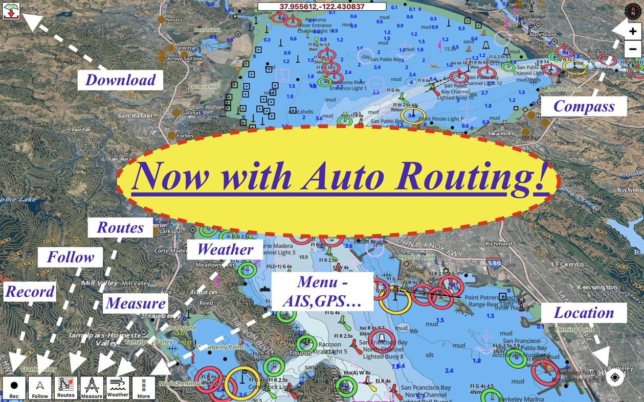
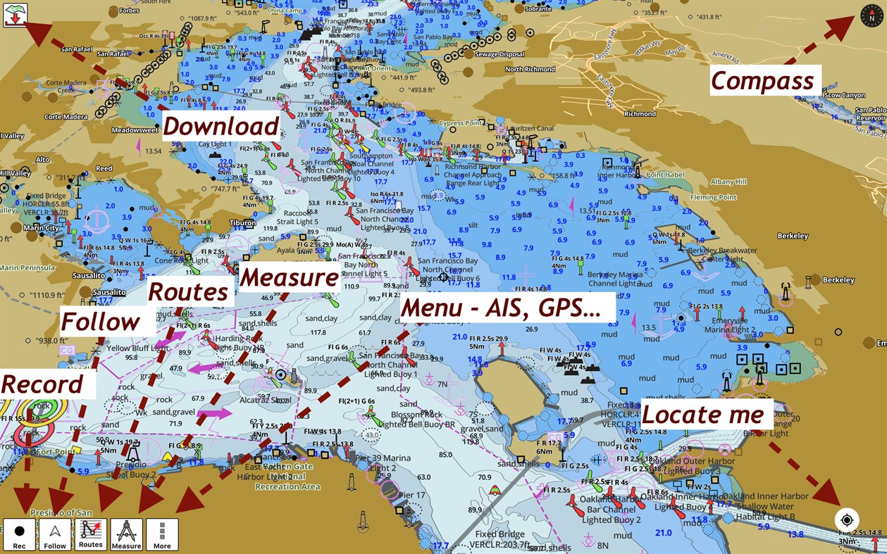
►FEATURES
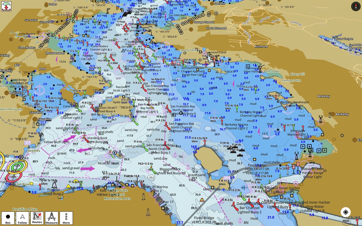
√ Download Beautiful & detailed Hardware/GPU accelerated vector charts (text stays upright on rotation)
√ Query details of Maritime object (Buoy, Lights, Obstruction etc).
√ Custom depth(Ft/Fathom/Meter) & distance units (km/mi/NM)
√ Custom depth shading (safety depth).
√ Record tracks, Autofollow with real-time track overlay
√ 1ft / 3ft depth contour maps for anglers for selected lake maps. Useful for fishing/trolling(freshwater/saltwater).
√ Supports GPX/KML for boating route editing/import.
√ Tide & Currents.
√ Seamless chart quilting. Map details from Coastal, Approaches,Harbour, Inland Encs(rivers), and general ENC (Electronic Marine Charts) mapped to right zoom
√ Enter/import Waypoints.
► MAPS
Get all the details that you find in your chartplotters!
Includes unlimited updates for 1 year.
USA: Maps incl coverage of all NOAA ENC,USACE inland river maps & freshwater lake fishing maps for more than 7K lakes. Charts include HD/1ft/3ft bathymetry where available. Also incl NOAA raster charts for areas where NOAA ENC coverage isn't available.
Canada: CHS data including rasters for some regions. Incl Great lakes(US & Canada sides),Alberta & Ontario lakes,Lake Simcoe&Trent Severn Canal.
UK/Ireland: UKHO charts
Germany:BSH charts,Waterways & rivers.
France
Europe Inland Rivers:Donau/Danube/Dunaja,Rhine,Rhein,Garonne,Moselle,Drava,Sava
Australia
Netherland/Holland
Croatia
Finland
Norway
Sweden
Russia,
Ukraine(Black Sea)
Brazil
Spain
Malta, Cypress & S. Mediterranean Sea
Caribbean
New Zealand
Denmark,Greenland,Faroe
Seychelles,Mauritius,Tanzania
Falklands,
Malaysia, South China Sea,
Persian/Arabian Gulf,Red Sea
South Africa,
Argentina,
Iceland,
Fiji,
Estonia,Latvia
Turkey,Greece,Italy
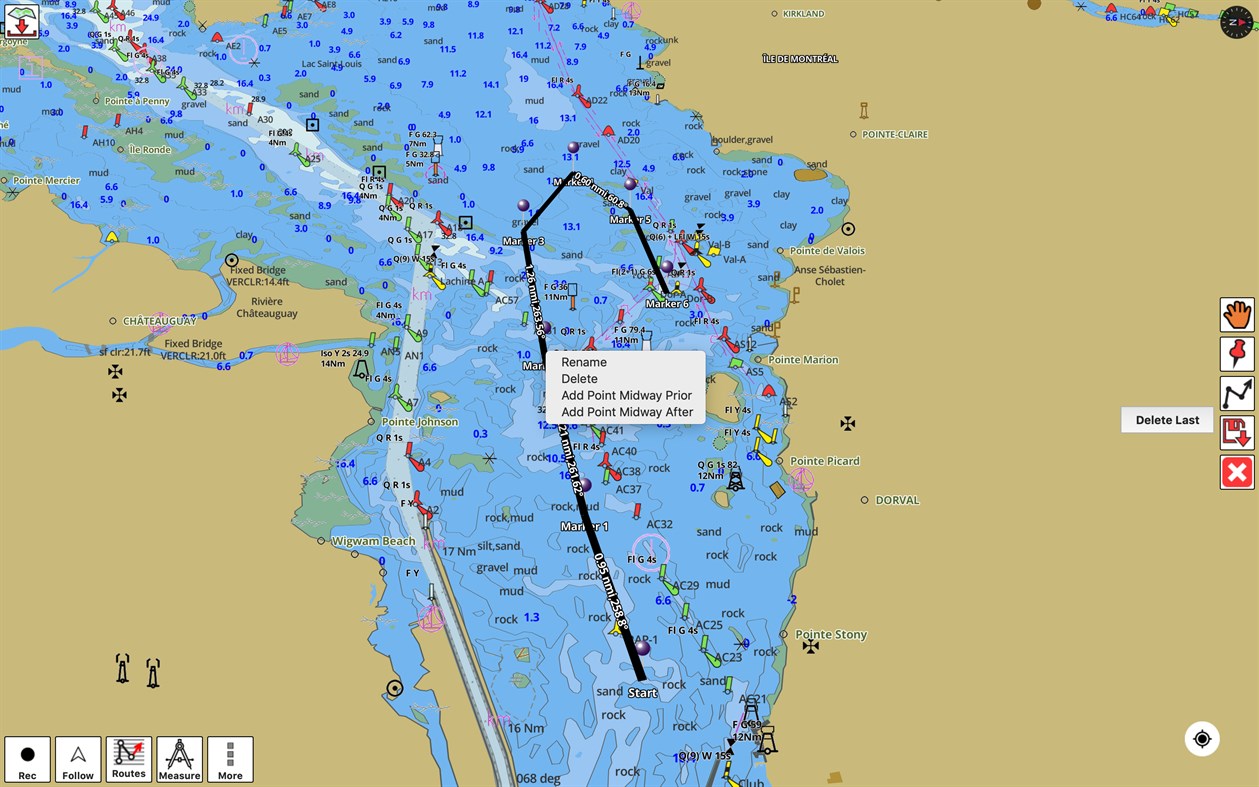
►ROUTE MANAGEMENT / TRIP PLANNING
√ Create New Route/Edit Routes
√ Reverse Routes
√ Enter,Move, Add, Delete, Rename Waypoints
√ Import GPX, KML & KMZ files
√ Plot/Edit Routes
√ Share/Export Routes, Tracks & Markers
►GPS FEATURES
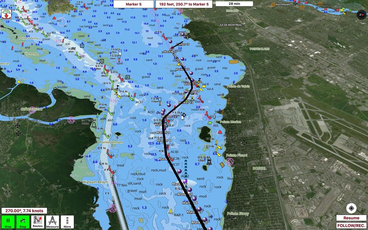
√ Auto Follow
* Real Time Track Overlay
* Predicted Path Vector
* Course Up (Text stays upright)
* Speed & Heading
√ Route Assistance With Voice Prompts
* Prompts when approaching a boating route marker
* Continous distance & ETA updates
* Alerts when sailing/boating off route
* Alerts when boating in wrong direction
√ Record Tracks
►AUTO ROUTING
√ Fully Automatic Slip to Slip
√ Avoid Hazards, obstructions
√ Safe for Boat's Draft
√ Optimized for Time, Distance & Fuel Consumption
►TIDE & CURRENTS
* For US, Canada, UK, Germany & New Zealand
* High/Low Tides
* Tidal Current Prediction
* Active Current Stations
► SHARING
* Share tracks/routes/markers on Facebook & Twitter
* Export tracks/routes/markers as compressed GPX files.
►Instrumentation
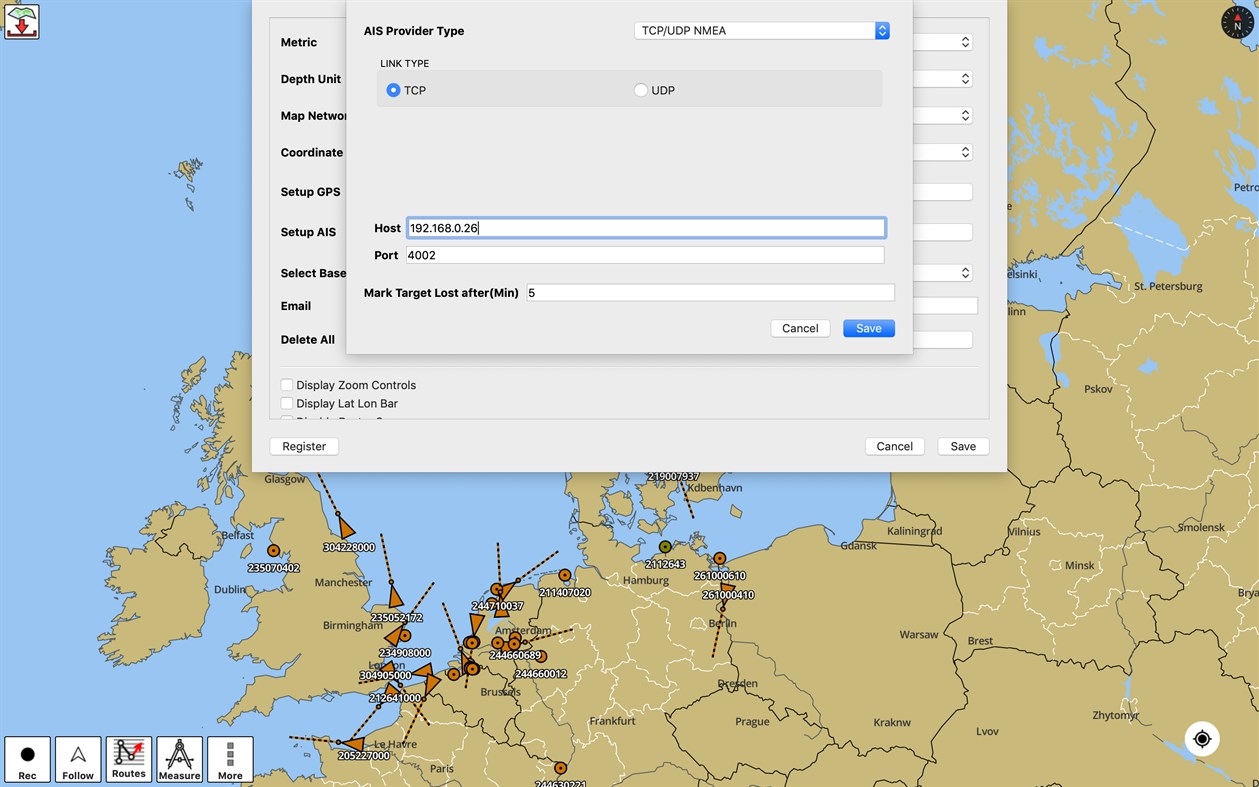
√ Marine AIS & (NMEA AIS and GPS over TCP/UDP)
√ Wind direction & Speed,Marine Sonar depth,Water temperature
Sample Nautical Charts (See http://gpsnauticalcharts.com/main/folio-catalog-nautical-charts-app for complete list)
...
USA:
Texas lakes: Eufaula, texoma
Florida lakes: Okeechobee
Massachussets lakes: Quabbin
Wisconsin Lakes: Winnebago
Minnesota lakes- Minnetonka, Waconia,Leech,Mille Lacs
Maine: Sebago
Alaska:
Winnipesaukee, Ontario, Huron, Erie, Michigan, Superior
TAMPA BAY
CHESAPEAKE BAY CAPE CHARLES-NORFOLK HARBOR
ANCLOTE KEYS-CRYSTAL RIVER
MIAMI HARBOR
Keowee,Jocassee,Hartwell,Greenwood,Lake Murray
Rainy Lake
Quebec to Anticosti Island West
Gulf of St. Lawrence South
Newfoundland East & South
Great lakes Canada & St. Lawrence river
Manitoba & Saskatchewan
Georgian Bay
Gulf of St. Lawrence North-Newfoundland West
Puget Sound
north sea
pacific ocean
KEY WEST-MISSISSIPPI
SAN PEDRO
LAKE MICHIGAN STONY LAKE-POINT BETSIE
APALACHICOLA BAY-CAPE SAN BLAS
MONHEGAN ISLAND-CAPE ELIZABETH
SAN FRANCISCO
MIAMI-MARATHON
BLACKBURN
HURON
TAHOE
Canada :
Lac Saint Jean
Ontario Lakes
Rideau Canal- Ottawa River
British Columbia
Pacific Coast- Vancouver- Haida Gwaii
Nova Scotia South- Bay of Fundy
United Kingdom / Ireland:
BRISTOL CHANNEL & SOUTH IRELAND
ENGLAND S COAST & SCILLIES
IRELAND W C-KENMARE R-FORELAND
IRISH SEA
N&E SCOTLAND-LEWIS-FORTH-N ISLES
NORTH SEA-FORTH-THAMES ENTRANCE
SCOTLAND KINTYRE-LOCH BROOM
THAMES-MEDWAY & APPROACHES
Popular charts/Folios:
Rainy Lake and Lake of the Woods
Quebec to Anticosti Island West
Gulf of St. Lawrence South
Ontario Lakes
Trent-Severn Waterway
Labrador Coast
Lac Saint Jean
Rideau Canal - Ottawa River
Georgian Bay
Newfoundland East and South
Great lakes Canada and St. Lawrence river
Lakes and Rivers in Manitoba and Saskatchewan
Lakes and Rivers of British Columbia
Pacific Coast - Vancouver Island East & West - Haida Gwaii
Lakes around Georgian Bay
Gulf of St. Lawrence North - Newfoundland West
Alberta Lakes
Nova Scotia South - Bay of Fundy
GULF OF MEXICO
GENERAL CHART OF THE GREAT LAKES
CAPE SABLE TO CAPE HATTERAS
STRAITS OF FLORIDA AND APPROACHES
KEY WEST TO THE MISSISSIPPI RIVER
CAPE CANAVERAL TO KEY WEST
CAPE HATTERAS TO STRAITS OF FLORIDA
NORTH PACIFIC OCEAN EASTERN PART
HAVANA TO TAMPA BAY
LEASE BLOCK FOR HAVANA TO TAMPA BAY
WEST QUODDY HEAD TO NEW YORK-EAST COAST
MEXICAN BORDER TO DIXON ENTRANCE
NEWPORT TO BERMUDA
NANTUCKET SHOALS TO FIVE FATHOM BANK
HAVANA TO TAMPA BAY
ESTERO BAY-LEMON BAY INCL. CHARLOTTE HARBOR
CHESAPEAKE BAY EASTERN BAY AND SOUTH RIVER
TAMPA BAY AND ST JOSEPH SOUND
TAMPA BAY - PORT RICHEY TAMPA BAY - CLEARWATER HBR
FORT MYERS TO CHARLOTTE HARBOR and WIGGINS PASS
SANDS KEY TO BLACKWATER SOUND
CHEASAPEAKE BAY COVE POINT TO SANDY POINT
CHESAPEAKE BAY SANDY PT TO SUSQUEHANNA RIVER
ANNAPOLIS HARBOR
CHARLESTON LIGHT TO CAPE CANAVERAL
INTRACOASTAL WATERWAY MIAMI TO ELLIOTT KEY
CAPE MAY TO CAPE HATTERAS
CHARLOTTE HARBOR TO TAMPA BAY
CHESAPEAKE BAY SEVERN AND MAGOTHY RIVERS
TAMPA BAY NORTHERN SECTION
MIAMI HARBOR
FORT MYERS TO CHARLOTTE HARBOR and WIGGINS PASS
TAMPA BAY TO CAPE SAN BLAS
FOWEY ROCKS TO AMERICAN SHOAL
CHESAPEAKE BAY - MARYLAND CHESTER RIVER
CHESAPEAKE BAY CHOPTANK RIVER AND HERRING BAY
KENT ISLAND NARROWS
Vancouver Island\Ile de Vancouver, Juan de Fuca Strait to\a Queen Charlotte Soun
Strait of Georgia, Southern Portion\Partie Sud
Lake Ontario\Lac Ontario
LAKE SIMCOE
Strait of Georgia, Central Portion\Partie Centrale (Part 1 of 2)
Strait of Georgia, Northern Portion\Partie Nord
Georgian Bay \ Baie Georgienne
Strait of Georgia, Central Portion\Partie Centrale (Part 2 of 2)
North Pender Island to\a Thetis Island
Thetis Island to\a Nanaimo
Juan de Fuca Strait to\a Strait of Georgia (Western Portion, Part 1 of 2)
Howe Sound
Active Pass
Nanaimo Harbour and\et Departure Bay
Approaches to\Approches a Vancouver Harbour
Haro Strait, Boundary Pass and\et Satellite Channel
Vancouver Harbour, Western Portion\Partie Ouest
Telegraph Harbour and\et Preedy Harbour
Ganges Harbour and\et Long Harbour
Dodd Narrows to\a Flat Top Islands
Baynes Sound
Approaches to\Approches a Sidney
Desolation Sound and\et Sutil Channel
Porlier Pass
Fraser River\Fleuve Fraser, Strait of Georgia to\a Mitchell Island
Fraser River\Fleuve Fraser, Sand Heads to\a Douglas Island AB
Secret Cove and\et Smuggler Cove
Race Rocks to\a D'Arcy Island
Roberts Bank
Bedwell Harbour to\a Georgeson Passage
Montague Harbour
Pender Harbour
Fulford Harbour
Sansum Narrows
Welcome Passage
Vancouver Harbour, Central Portion\Partie Centrale
Shoal Channel
Approaches to\Approches a Nanoose Harbour
Jervis Inlet
English Channel
British Isles
The Solent and Southampton Water
English Channel Central Part
Irish Sea with Saint George's Channel and North Channel
British Isles
Anvil Point to Beachy Head
Saint George's Channel and Bristol Channel
Cowes Harbour and River Medina
Southampton Water
Solent
A Beaulieu River
Scotland West Coast
Bill of Portland to the Needles
River Medina Folly Point to Newport
Portsmouth Harbour
Langstone and Chichester Harbours
B Port Hamble to Bursledon
Start Point to The Needles including Off Casquets TSS
Poole Harbour
Newtown River
Irish Sea
Poole Bay
Wootton Creek
River Hamble
Lymington River
Portsmouth
Yarmouth Harbour
Fareham Lake
Sandown Bay
Hillhead Harbour
Bembridge
Thames Estuary
Suomi:
Norge:kysten Bergen Narvik Florø Risør Oslo
Spain:
Brazil:MACAU, SALVADOR, RIO, JANEIRO, BARIRI, ITARIRI,Santos, Cabo, Frio
Ukraine(Black Sea):Bilhorod-Dnistrovsky Seaport,Illichivsk,Odessa,Yevpatoriya,Mykolaiv,Oktyabrsk,Kherson,Sevastopol,Skadovsk,Feodosiya,Yalta
Caribbean:Antigua,Castries,Gustavia,Esquivel,Freeport,Kingston Harbour,Nevis,Port Kaiser,Crooked Island Passage& Exuma Sound,Salt River Anchorage,Speightstown incl. Arawak Jetty,Cuba to Miskito Bank,Basseterre Bay,Bullenbaai,Fuik Baai,Groot Baai,Marigot Harbour,Dominica,Rio Bueno,Scarborough
Malta:Ghawdex(Gozo)-Kemmuna,Marsaxlokk,Valletta
New Zealand:Tauranga,Lyttelton,Napier,Otago,Wellington
Capturas...

Novedades
- Versión: PC
- Actualizado:
Precio
- Hoy: Gratis
- Mínimo: Gratis
- Máximo: Gratis
Realizar un seguimiento de los precios
Desarrollador
- Bist LLC
- Plataformas: iOS Aplicaciones (18) macOS Aplicaciones (2) Windows Aplicaciones (9)
- Listas: 2 + 0
- Puntos: 2 + 15,041 ¡
- Clasificaciones: 0
- Opiniones: 0
- Descuentos: 0
- Vídeos: 0
- RSS: Suscribirse
Puntos

Clasificaciones
No encontrada ☹️
Listas
No encontrada ☹️
Opiniones
Sé el primero en escribir una reseña!
Información adicional
- Categoría:
Windows Aplicaciones›Navegación y mapas - Sistemas operativos:
PC - Tamaño:
69 Mb - Idiomas admitidos:
English - Clasificación de contenido:
EVERYONE - Windows Store Puntuación:
4.8(17) - Actualizado:
- Fecha de lanzamiento:
Contactos
También te puede interesar
-
- i-Boating:Marine Navigation Maps & Nautical Charts
- Windows Aplicaciones: Navegación y mapas De: Bist LLC
- * Gratis
- Listas: 1 + 0 Clasificaciones: 0 Opiniones: 0
- Puntos: 0 + 235 Versión: PC This App offers offline nautical charts, lake & river navigation maps for fishing, kayaking, boating, yachting & sailing. Marine navigation coverage includes marine vector charts, ...
-
- GPS Routes
- Windows Aplicaciones: Navegación y mapas De: Kathy Grobbelaar
- Gratis
- Listas: 0 + 0 Clasificaciones: 0 Opiniones: 0
- Puntos: 1 + 8 Versión: PC GPS Routes lets you download GPX and KML Route files into the app from your device. Display the downloaded route and your current position on Bing Maps while walking/driving the route.
-
- GPS Satellite
- Windows Aplicaciones: Navegación y mapas De: KarhuKoti
- * Gratis
- Listas: 0 + 0 Clasificaciones: 0 Opiniones: 0
- Puntos: 2 + 714 Versión: PC GPS Satellite provides the location and course data calculated from your phone's global positioning satellite (GPS) receive in conjunction with received orbiting global position ...
-
- GPS-GPX Logger Pro
- Windows Aplicaciones: Navegación y mapas De: Ben Byer
- $0.99
- Listas: 0 + 0 Clasificaciones: 0 Opiniones: 0
- Puntos: 0 + 5 Versión: PC New! Additional language support. Currently supports Chinese, Dutch, English, French, German, Italian, Polish, Russian and Spanish A great mapping and trip logging app. Uses the ...
-
- GPS Hiking Mate 10
- Windows Aplicaciones: Navegación y mapas De: Lollus
- Gratis
- Listas: 0 + 0 Clasificaciones: 0 Opiniones: 0
- Puntos: 0 + 10 Versión: PC This app is an intelligent map for trekking or biking. It can tell where you are, where you have been and where you decided to go, but it won't tell you to turn left or right or find ...
-
- Maps for Gmaps
- Windows Aplicaciones: Navegación y mapas De: Rushi
- * Gratis
- Listas: 1 + 0 Clasificaciones: 0 Opiniones: 0
- Puntos: 0 + 44 Versión: PC Our version of Gmaps 8 is the client of Top-Rated app on other platforms that is google map.Gmaps 8 can be used for finding places and directions. ** This is an unofficial client of ...
-
- GPS Map+
- Windows Aplicaciones: Navegación y mapas De: WzzT
- Gratis
- Listas: 0 + 0 Clasificaciones: 0 Opiniones: 0
- Puntos: 3 + 289 Versión: PC Good map with good tools: Searching place and navigating there. Getting the weather information on map. Tell your friends where are you and how to find you! Share your location and ...
-
- Live Mobile Location and GPS Coordinates
- Windows Aplicaciones: Navegación y mapas De: Good Job Apps
- * Gratis
- Listas: 1 + 0 Clasificaciones: 0 Opiniones: 0
- Puntos: 2 + 195 Versión: PC GPS Navigation is a new powerful GPS app with GPS, Maps, Navigations & Directions functions all in one app. TOP FEATURES GPS Route Finder Route Planner will plan the shortest route for
-
- Windows Maps
- Windows Aplicaciones: Navegación y mapas De: Microsoft Corporation
- Gratis
- Listas: 5 + 1 Clasificaciones: 0 Opiniones: 0
- Puntos: 5 + 38,996 Versión: PC Maps is your guide to everywhere. Find your way with voice navigation and driving, transit, and walking directions. Search for places to get directions, business info, and reviews. ...
-
- MapFactor GPS Navigation
- Windows Aplicaciones: Navegación y mapas De: MapFactor
- * Gratis
- Listas: 0 + 0 Clasificaciones: 0 Opiniones: 0
- Puntos: 0 + 88 Versión: PC MapFactor Navigator is a free turn-by-turn GPS navigation app for Windows phones, tablets and PCs using OpenStreetMaps data. Maps are installed on your device or SD card so there is no
-
- WinGo Maps
- Windows Aplicaciones: Navegación y mapas De: Mah Studios
- $2.99
- Listas: 0 + 0 Clasificaciones: 0 Opiniones: 0
- Puntos: 0 + 17 Versión: PC WinGo Maps is an Unofficial Google Map open source client for Windows 10 developed by MahStudio. This app made for Windows 10 devices family (PC, HoloLens, XBOX, Mobile and etc.) and ...
-
- Yandex.Maps
- Windows Aplicaciones: Navegación y mapas De: Yandex
- Gratis
- Listas: 1 + 1 Clasificaciones: 0 Opiniones: 0
- Puntos: 0 + 58 Versión: PC Updated version for Windows 10 · World map · City guides · Walking directions · Directions for driving and public transportation · Real-time public transportation on the map · ...
-
- Open with Maps
- Windows Aplicaciones: Navegación y mapas De: ayamadori
- * Gratis
- Listas: 1 + 0 Clasificaciones: 0 Opiniones: 0
- Puntos: 2 + 50 Versión: PC A simple complement(helper) for the Windows Maps app. ** You can buy Donation to support me, thanks! ** ## Feature - Open URL of map service (e.g. Place, Search, Route of Google Maps) ...
-
- Test GPS Device
- Windows Aplicaciones: Navegación y mapas De: Liliya Muray
- $2.99
- Listas: 0 + 0 Clasificaciones: 0 Opiniones: 0
- Puntos: 0 + 3 Versión: PC The program "Test GPS Device" is intended to test the operation of GNSS sensor your device with Windows 10. The same application checks for the main sensor and display their data. The ...
También te puede interesar
- Windows Aplicaciones
- Nuevas Windows Aplicaciones
- Navegación y mapas Windows Aplicaciones : Nuevas
- Vídeos Windows Aplicaciones
- Populares Windows Aplicaciones
- Navegación y mapas Windows Aplicaciones : Populares
- Descuentos Windows Aplicaciones
- Navegación y mapas Windows Aplicaciones : Descuentos
- Clasificaciones Windows Aplicaciones
- Opiniones Windows Aplicaciones
- Listas Windows Aplicaciones
- Puntos Windows Aplicaciones