| Desarrollador: | MICRI Consult BVBA (5) | ||
| Precio: | Gratis | ||
| Clasificaciones: | 0 | ||
| Opiniones: | 0 Escribir una opinión | ||
| Listas: | 0 + 0 | ||
| Puntos: | 0 + 0 ¡ | ||
| Puntos + 1 | |||
Descripción
")
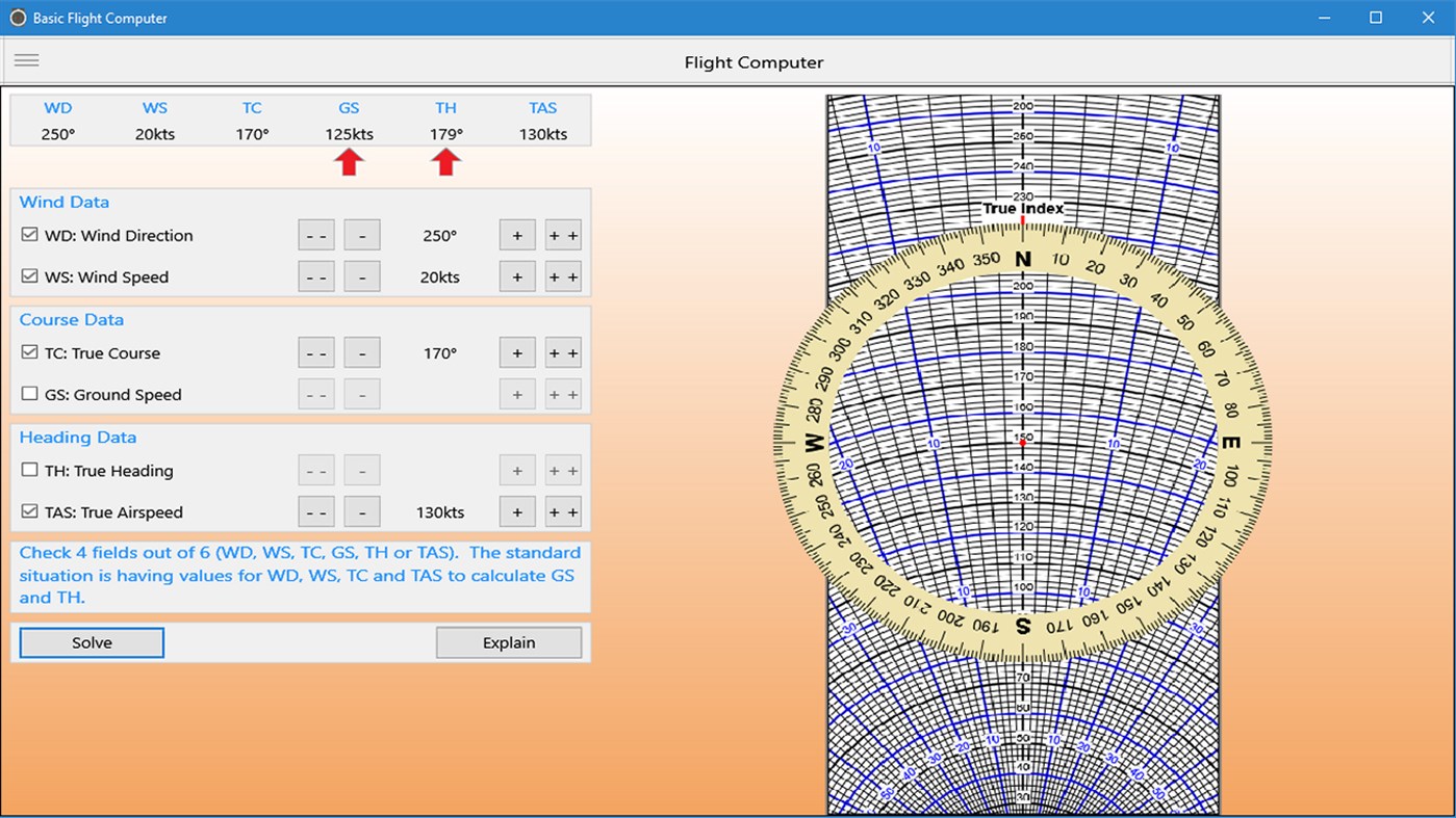
Contains "--", "-". "+" and "++" buttons to enter a value. Click them to decrease/increase a value. Keep the mouse pressed to keep decreasing/increasing a value. "--" decreases 5 times faster than "-" and "++" increases 5 times faster than "+".
Capturas...

Novedades
- Versión: PC
- Actualizado:
Precio
- Hoy: Gratis
- Mínimo: Gratis
- Máximo: Gratis
Realizar un seguimiento de los precios
Desarrollador
- MICRI Consult BVBA
- Plataformas: Windows Aplicaciones (4) Windows Juegos (1)
- Listas: 1 + 0
- Puntos: 1 + 0 ¡
- Clasificaciones: 0
- Opiniones: 0
- Descuentos: 0
- Vídeos: 0
- RSS: Suscribirse
Puntos
No encontrada ☹️
Clasificaciones
No encontrada ☹️
Listas
No encontrada ☹️
Opiniones
Sé el primero en escribir una reseña!
Información adicional
- Categoría:
Windows Aplicaciones›Navegación y mapas - Sistemas operativos:
PC - Tamaño:
3 Mb - Idiomas admitidos:
English - Clasificación de contenido:
EVERYONE - Windows Store Puntuación:
0 - Actualizado:
- Fecha de lanzamiento:
También te puede interesar
-
- VFR Navigator X
- Windows Aplicaciones: Navegación y mapas De: Pilot Pocket Software
- * Gratis
- Listas: 0 + 0 Clasificaciones: 0 Opiniones: 0
- Puntos: 1 + 8 Versión: PC Basic moving map app with offline VFR sectional charts and terminal procedure publications for lower US states. Contains data on waypoints, navaids, over 5000 public airports, and ...
-
- skybook Aviation Cloud
- Windows Aplicaciones: Navegación y mapas De: Keyzo IT Solutions Ltd
- Gratis
- Listas: 0 + 0 Clasificaciones: 0 Opiniones: 0
- Puntos: 0 + 0 Versión: PC skybook Aviation Cloud is an application developed by Bytron Aviation Systems and is intended to be used by the aviation industry only. Our skybook app is so much more than an ...
-
- UAV Drone Controller App - SDD Test
- Windows Aplicaciones: Navegación y mapas De: Gavin Hays
- Gratis
- Listas: 0 + 0 Clasificaciones: 0 Opiniones: 0
- Puntos: 0 + 2 Versión: PC Note: This app is not functional, and is for a Software Design & Development project. It is only for the purpose of understanding how the hypothetical app would function. 'To control ...
-
- i-Boating: WMTS - Marine & Lakes
- Windows Aplicaciones: Navegación y mapas De: Bist LLC
- Gratis
- Listas: 0 + 0 Clasificaciones: 0 Opiniones: 0
- Puntos: 0 + 0 Versión: PC The i-Boating WMTS is a dynamic web map tile service Compatible with QGIS, ArcGIS, GrassGIS. It runs on your computer and covers marine charts and lake depth maps.. The i-Boating WMTS ...
-
- Distance Master
- Windows Aplicaciones: Navegación y mapas De: Daniel Reust
- Gratis
- Listas: 0 + 0 Clasificaciones: 0 Opiniones: 0
- Puntos: 0 + 2 Versión: PC Finds distances all over the world. With map view and additional functions e.g. flight time.
-
- C-AS eFB
- Windows Aplicaciones: Navegación y mapas De: AP-TECH Spółka z o.o.
- Gratis
- Listas: 0 + 0 Clasificaciones: 0 Opiniones: 0
- Puntos: 0 + 0 Versión: PC C-AS eFB is an innovative flight bag explorer for Windows.
-
- My Map Routes
- Windows Aplicaciones: Navegación y mapas De: DSBT Software LLC
- $2.99
- Listas: 0 + 0 Clasificaciones: 0 Opiniones: 0
- Puntos: 0 + 1 Versión: PC With My Map Routes, you can use an intuitive visual interface to build your daily jogging, walking, biking, and driving routes and find out how long they are. You can even use our ...
-
- Yandex.Maps
- Windows Aplicaciones: Navegación y mapas De: Yandex
- Gratis
- Listas: 1 + 1 Clasificaciones: 0 Opiniones: 0
- Puntos: 0 + 58 Versión: PC Updated version for Windows 10 · World map · City guides · Walking directions · Directions for driving and public transportation · Real-time public transportation on the map · ...
-
- GPS-RDN
- Windows Aplicaciones: Navegación y mapas De: AIKON
- Gratis
- Listas: 0 + 0 Clasificaciones: 0 Opiniones: 0
- Puntos: 0 + 0 Versión: PC GPS-RDN does give you the lat/long location in the four most used formats, taken from the GPS. Internet degrees; decimal degrees; degrees and decimal minutes; degrees, minutes and ...
-
- Cartograph Maps Pro
- Windows Aplicaciones: Navegación y mapas De: teq-IT
- $17.49
- Listas: 1 + 0 Clasificaciones: 0 Opiniones: 0
- Puntos: 0 + 1 Versión: PC The Cartograph 2 app views Mapsforge offline vector maps, offline raster maps, and online/WMS maps. It supports tracking, route search, overlays, hillshading, reliefs, track drawing, ...
-
- Walter Maps
- Windows Aplicaciones: Navegación y mapas De: Dianthus AB
- * Gratis
- Listas: 0 + 0 Clasificaciones: 0 Opiniones: 0
- Puntos: 0 + 2 Versión: PC Walter Maps is a professional tool for online and fully offline geodata collection and editing. You can use it stand alone or as a ready-to-use field data collection tool in your ...
-
- ezAlmanac Celestial Navigation
- Windows Aplicaciones: Navegación y mapas De: EZ Celestial LLC
- $29.99
- Listas: 0 + 0 Clasificaciones: 0 Opiniones: 0
- Puntos: 0 + 1 Versión: PC Celestial navigation has never been easier! With ezAlmanac and a sextant you will be finding your fix like a pro in no time! ezAlmanac will help you perform celestial navigation ...
-
- Route Mapper
- Windows Aplicaciones: Navegación y mapas De: GreenHouseApps
- Gratis
- Listas: 0 + 0 Clasificaciones: 0 Opiniones: 0
- Puntos: 0 + 8 Versión: PC This is a basic tool that will allow you to measure various routes. If you plan running routes often and need to know how far a 5 mile or 10 mile run is, then use Route Mapper to plan ...
-
- NavPlotter
- Windows Aplicaciones: Navegación y mapas De: MaxMin00
- Gratis
- Listas: 0 + 0 Clasificaciones: 0 Opiniones: 0
- Puntos: 0 + 1 Versión: PC NavPlotter is a simple marine navigator based on openseamap.org . This version of the NavPlotter provides the following basic navigation functions: real time positioning (instantly ...
También te puede interesar
- Windows Aplicaciones
- Nuevas Windows Aplicaciones
- Navegación y mapas Windows Aplicaciones : Nuevas
- Vídeos Windows Aplicaciones
- Populares Windows Aplicaciones
- Navegación y mapas Windows Aplicaciones : Populares
- Descuentos Windows Aplicaciones
- Navegación y mapas Windows Aplicaciones : Descuentos
- Clasificaciones Windows Aplicaciones
- Opiniones Windows Aplicaciones
- Listas Windows Aplicaciones
- Puntos Windows Aplicaciones