| Developer: | Mappendix Limited (4) | ||
| Price: | $9.99 | ||
| Rankings: | 0 | ||
| Reviews: | 0 Write a Review | ||
| Lists: | 0 + 0 | ||
| Points: | 0 + 5 ¡ | ||
| Points + 1 | |||
Description
")
After installing the app, please touch the '?' button to view instructions including how to download detailed maps.
Northern Ireland is not included. The Isle of Man is included only at 1:250,000 (free) and 1:50,000 (paid). The Channel Islands are not included.
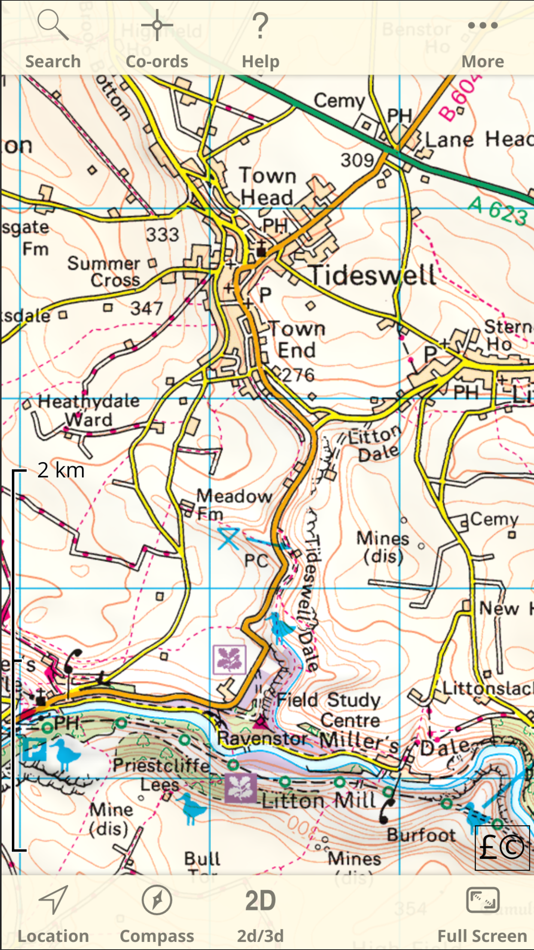
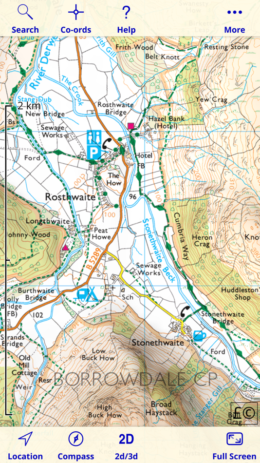
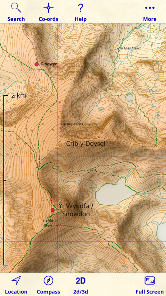
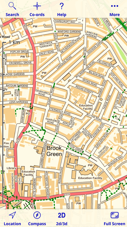
Since 2010, Britain's national mapping agency Ordnance Survey has released a large amount of free map data. UK Map makes much of that data available in a single app. It includes 1:1M MiniScale® and 1:250k road maps, which are built into the app, and 1:25k district maps and 1:10k street maps for the entire country which you can download in 5km by 5km tiles. As the free O.S. data does not include footpaths, this app superimposes footpaths derived from volunteer-collected data from OpenStreetMap.org. These downloads are free of charge.
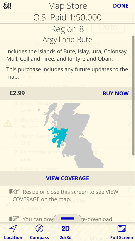
In addition to the free maps, you can also purchase and download 1:50,000 and 1:25,000 maps that are just like the Ordnance Survey paper maps. You can also purchase 1:10,000 maps for selected urban areas which show more detail than the free 1:10,000 maps.
Once you've downloaded the detailed maps that you need, an internet connection is not required.
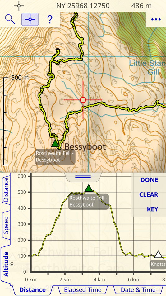
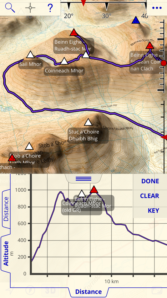
The app can load GPX files (for example, from websites, other apps and from nearby devices via AirDrop) and display waypoints, tracks and routes. You can also mark waypoints, plan routes and record tracks within the app, and export them.
You can view graphs of altitude or speed along recorded tracks and routes.
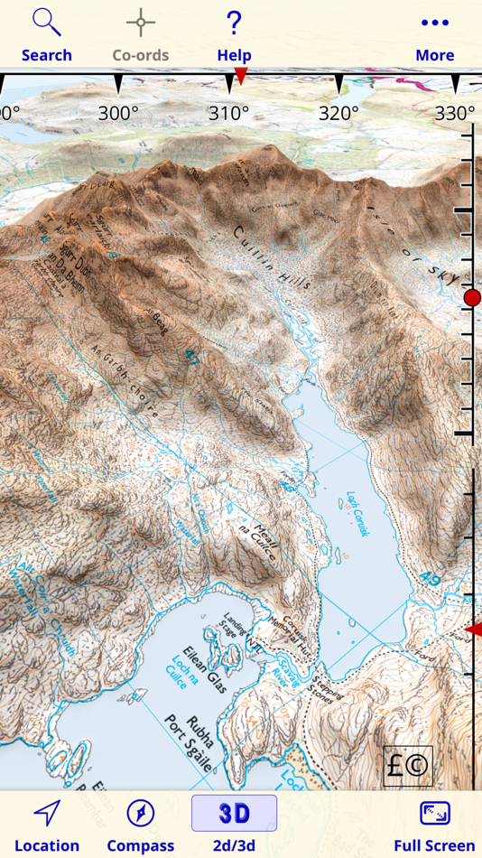
The app has a 3D mode that lets you view the terrain from any viewpoint, useful for visualising hills and mountains.
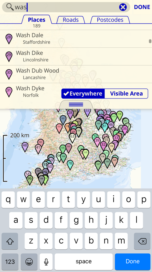
The app also includes a searchable gazetteer containing over 250,000 place names, 850,000 street names and 1.6 million post codes. All of this data is built in to the app, so this search also works when there is no network connection.
The app also supports the compass and GPS - on those devices that have them - to display your position, orientation and altitude.
Paid maps are licensed for personal and non-commercial use only.
Contains Ordnance Survey data © Crown copyright and database rights 2011 - 2024. Please visit the website for more information - https://ukmapapp.com/
Screenshots

What's new
- Version: 4.10
- Updated:
- This is a bug-fix update.
Price
- Today: $9.99
- Minimum: $6.99
- Maximum: $9.99
Track prices
Developer
- Mappendix Limited
- Platforms: iOS Apps (4)
- Lists: 0 + 0
- Points: 0 + 140 ¡
- Rankings: 0
- Reviews: 0
- Discounts: 0
- Videos: 0
- RSS: Subscribe
Points
Not found ☹️
Rankings
Not found ☹️
Lists
Not found ☹️
Reviews
Be the first to review!
Additional Information
- Category:
iOS Apps›Navigation - OS:
iPad,iPhone,iOS 12.0 and up - Size:
288 Mb - Supported Languages:
English - Content Rating:
4+ - App Store Rating:
3.4(5) - Updated:
- Release Date:
Contacts
- Website:
 https://ukmapapp.com/
You may also like
-
- Bus Times UK
- iOS Apps: Navigation By: Mapway Limited
- Free
- Lists: 0 + 0 Rankings: 0 Reviews: 0
- Points: 0 + 23 Version: 2.1.3 Shopping trip to Birmingham? A night at the theatre in Edinburgh? A big night out in Brighton? Need a bus app that can find bus stops and check bus times? Bus Times UK is the fastest ...
-
- Zapmap: EV charging in the UK
- iOS Apps: Navigation By: Zapmap Limited
- * Free
- Lists: 0 + 0 Rankings: 0 Reviews: 0
- Points: 1 + 64 Version: 7.5.5 Helping you to stay charged, wherever you go. We ve got you covered from the UK, the Republic of Ireland, and across the European charging infrastructure and our thriving EV community ...
-
- London & UK Live Bus Countdown
- iOS Apps: Navigation By: Mobicia
- * Free
- Lists: 0 + 0 Rankings: 0 Reviews: 0
- Points: 0 + 1,403 Version: 20.3.27 UK Live Bus Times & Timetables from stops in England, Scotland & Wales * Over 5M downloads! * In the App Store Top Free Apps for Navigation London Live Bus Countdown tells you when ...
-
- Canals.UK
- iOS Apps: Navigation By: MARK MANSER
- * Free
- Lists: 0 + 0 Rankings: 0 Reviews: 0
- Points: 0 + 16 Version: 4.8 Canals.UK is a useful companion for anyone who uses the canals; boating or walking! Navigate the 2,000 miles of UK canals. The App shows locks, bridges, aqueducts, tunnels, mooring and
-
- TfL Go: Live Tube, Bus & Rail
- iOS Apps: Navigation By: TfL
- Free
- Lists: 0 + 1 Rankings: 0 Reviews: 0
- Points: 0 + 5,343 Version: 1.61.0 Travel confidently around London with maps and live travel updates on our official TfL app. Check live arrival times for Tube, London Overground, DLR, Elizabeth line and Thameslink ...
-
- OS Locate
- iOS Apps: Navigation By: Ordnance Survey
- Free
- Lists: 0 + 0 Rankings: 0 Reviews: 0
- Points: 0 + 115 Version: 1.6.2 Make the most of your adventures in the great outdoors with OS Locate. Used alongside your Ordnance Survey map, OS Locate is a fast and highly accurate means of pinpointing your exact ...
-
- My Triumph
- iOS Apps: Navigation By: Triumph Motorcycles Ltd
- Free
- Lists: 0 + 0 Rankings: 0 Reviews: 0
- Points: 0 + 142 Version: 1.2.10 The new My Triumph app is built with Google and works in conjunction with the My Triumph Connectivity System to provide live navigation on your motorcycle via the TFT instruments. ...
-
- OutDoors GPS France - IGN Maps
- iOS Apps: Navigation By: RoadTour LLC
- Free
- Lists: 0 + 0 Rankings: 0 Reviews: 0
- Points: 0 + 32 Version: 6.5.7 ** France s No1 mapping and GPS app Ideal for following hiking and biking routes in total confidence Official Topo Maps (IGN) can be downloaded so app works anywhere regardless of ...
-
- Blueline Taxis
- iOS Apps: Navigation By: BLUE LINE TAXIS (NEWCASTLE) LTD
- Free
- Lists: 0 + 0 Rankings: 0 Reviews: 0
- Points: 0 + 16 Version: 741.1.0 Book a taxi in under 10 seconds and experience exclusive priority service from one of the largest taxi firms in North East. You can place the booking directly on our map, and see how ...
-
- Aqua Cars
- iOS Apps: Navigation By: Aqua Cars Limited
- Free
- Lists: 0 + 0 Rankings: 0 Reviews: 0
- Points: 0 + 4 Version: 34.5.17 The Aqua Cars iPhone app allows you to book and track your taxi, utilising our 700+ cars in the Portsmouth and surrounding areas. Using this App you can: - Make a booking of ASAP and ...
-
- fonaCAB Belfast
- iOS Apps: Navigation By: fonaCAB Belfast
- Free
- Lists: 0 + 0 Rankings: 0 Reviews: 0
- Points: 0 + 273 Version: 742.8.0 The new fonaCAB App is FREE to download and it costs you nothing to register. Book a Taxi with a few simple taps. Book your fonaCAB across Belfast, Lisburn, Craigavon, Lurgan, ...
-
- Speedometer, Speed Limit Alert
- iOS Apps: Navigation By: Dmitriy Kharutskiy
- Free
- Lists: 0 + 0 Rankings: 0 Reviews: 0
- Points: 0 + 13 Version: 2.11.1 1. Step-by-step audio notifications once you have reached your required speeds. 2. Speed data filtering. Readings with the filter on are more inert than those with the filter off ...
-
- Sat Nav Maps, GPS & Traffic
- iOS Apps: Navigation By: Karta
- * Free
- Lists: 0 + 1 Rankings: 0 Reviews: 0
- Points: 0 + 3 Version: 2.46.06 App Includes the UK map or any other country in the world! This special version offers free traffic and Speed Cameras information with lifetime updates. All maps are free and allow for
-
- Blue Badge Parking
- iOS Apps: Navigation By: Andrew Herring
- Free
- Lists: 0 + 0 Rankings: 0 Reviews: 0
- Points: 1 + 3 Version: 1.1.08 This app only grows if more locations are added by users, it s called Crowd-Sourcing so if you find there are no parking spaces shown in your local town for example, click link in ...