| Developer: | Adventure Pilot, LLC (3) | ||
| Price: | * Free | ||
| Rankings: | 0 | ||
| Reviews: | 0 Write a Review | ||
| Lists: | 0 + 0 | ||
| Points: | 2 + 113 ¡ | ||
| Points + 1 | |||
Description
")
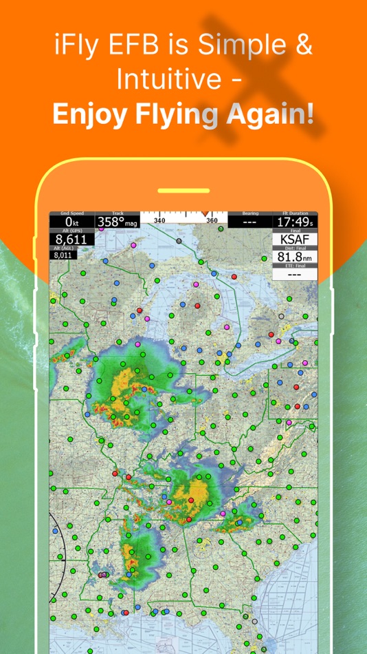
Key reasons to try iFly EFB:
1) Ease of use in the cockpit: Our intuitive and simple interface, easy to hit buttons, simple map gestures, large fonts, and more make this the best EFB for in-flight use
2) Pilot focused company: We have staff (pilots) on the ground at our office in Texas waiting to answer your questions. Call 214-585-0444 or email support@adventurepilot.com, we're here to help
3) Price: We are one of the most competitively priced EFBs on the market
4) Capabilities: We are one of the most capable EFBs on the market! Need proof? Visit www.iFlyEFB.com/Compare
Following are some of our features and benefits:
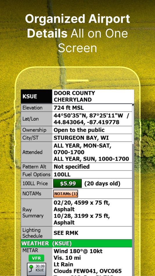
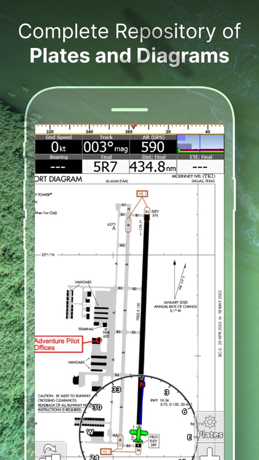
•Geo-Reference Approach Plates and Airport Diagrams
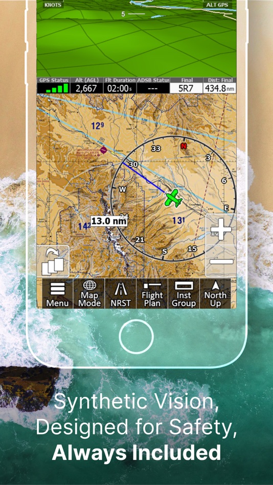
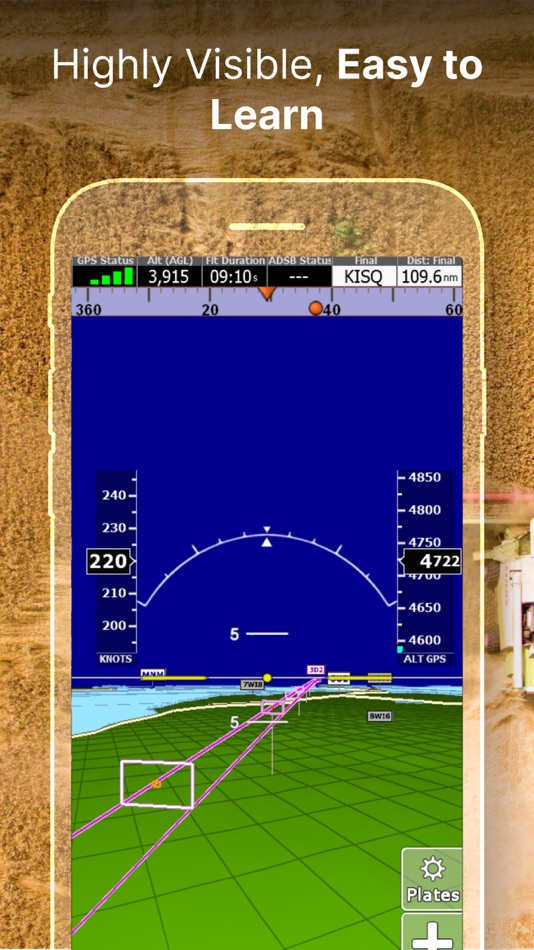
•3D Synthetic Vision / EFIS Mode
•Terrain, Obstructions, Traffic, and Airspaces Alerts
•Complete ADSB support
•AutoTaxi+ for safe taxing at any airport
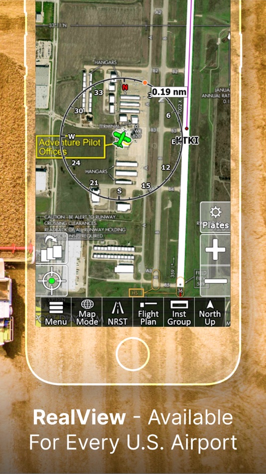
•RealView airport imagery
•RealPlan automatic VFR Planner
•Auto-load approach into plan
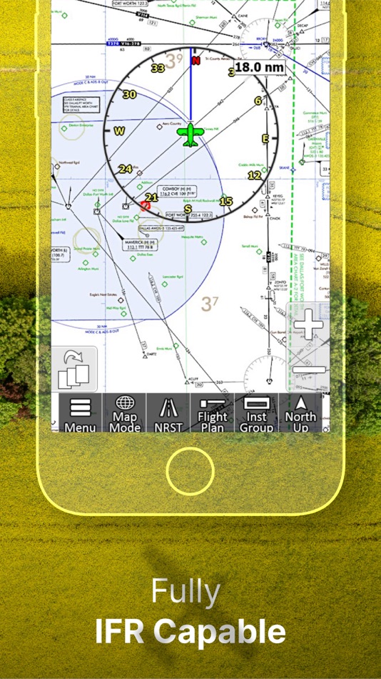
•Complete VFR and IFR databases and charts (FAA)
•Sectionals
•Customizable Instruments
•Public & Private Airports
•Winds aloft including forecasts for 36 hours
•Hi/Lo-Enroute Charts
•Terminal Area Charts(TAC)
•World Aeronautical Charts(WAC)
•Vector Mode
•Weather (Pre-Flight or ADS-B Live)
•Hi-res Winds Aloft Optimizing
•Rapid Flight planning
•Plates & Diagrams (Approach, Departure Plates, Stars, SIDs Airport Diagrams)
•Instruments Panel
•Day/Night Mode
•Online Flight Plan Filing
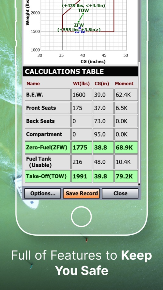
•Custom Instrument Layouts (24 Instruments, e.g. HSI, Vertical Profile, and AHRS)
•Vertical Terrain planning and Airspace preview
•Find Nearest
•History
•North Up / Track Up
•Pinch Zooming w/ One Touch Feature
•Dynamic Distance Ring
•Hybrid Compass Rose w/ Nav Function
•Extended Course Line
•Flight Trails
•Past Flights
•Rubber Band route modification
•Custom Aircraft icons
•AutoTaxi+
•Alerts & Warnings
•Button Fading (maximizes screen space)
•Custom User Waypoints
•Customizable Instruments
•Simulator Mode
Screenshots


What's new
- Version: 13.0.33
- Updated:
- (Re-release of 13.0.30 for iOS 13+ devices only.)
1. All new Map graphics engine to enable much faster rendering, with higher fidelity graphics and animations in the near future.
2. Map Rendering frame and fill rates are notably faster than in previous versions.
3. All new Vector Mode Hi-Res VFR-Colored Terrain and Elevation Highlights.
4. iOS - On certain devices, shrunk Top/Bottom black borders, making Portrait presentation taller.
5. Added Flight Plan Export option for ForeFlight.
6. Improved/Fixed support for Gyroplanes, and Icon.
7. Improved Avidyne user experience.
8. Enabled Weather Updates while downloading Map Data.
9. Improved handling of Instrument Layout adjustment when screen size is altered (for various reasons).
10. Support Links now open a browser or email directly.
11. Improved/Fixed for 1st Time User Experience - bug fixes and improvements.
12. Numerous bug fixes and performance improvements.
Price
-
*In-App Purchases - Today: Free
- Minimum: Free
- Maximum: Free
Track prices
Developer
- Adventure Pilot, LLC
- Platforms: Android Apps (1) iOS Apps (2)
- Lists: 0 + 0
- Points: 2 + 580 ¡
- Rankings: 0
- Reviews: 0
- Discounts: 0
- Videos: 0
- RSS: Subscribe
Points
-

- 103 Lass Ben-Attia
-
- 181 No need


Rankings
Not found ☹️
Lists
Not found ☹️
Reviews
Be the first to review!
Additional Information
- Category:
iOS Apps›Navigation - OS:
iPad,iPhone,iOS 13.0 and up - Size:
126 Mb - Content Rating:
4+ - App Store Rating:
4.5(113) - Updated:
- Release Date:
Contacts
- Facebook: Compare
- Website:
 http://www.iFlyEFB.com
You may also like
-
- Fly Virga
- iOS Apps: Navigation By: Aviation Apps, LLC
- Free
- Lists: 0 + 0 Rankings: 0 Reviews: 0
- Points: 0 + 17 Version: 1.57 Pilots can now unleash the power of real time PIREPs for flight planning, management and safety. Virga is aviation s only app that allows pilots to submit PIREPs without the need for ...
-
- AvPlan EFB
- iOS Apps: Navigation By: BJA Consulting Pty Ltd
- * Free
- Lists: 0 + 0 Rankings: 0 Reviews: 0
- Points: 1 + 81 Version: 9.7.3 Get flying faster with AvPlan EFB - the premier lifetime Electronic Flight Bag that grows with you. Continuing to lead the market with unparalleled innovation and functionality, AvPlan
-
- FlyQ EFB
- iOS Apps: Navigation By: Seattle Avionics, Inc.
- * Free
- Lists: 0 + 0 Rankings: 0 Reviews: 0
- Points: 1 + 558 Version: 6.9.0 FlyQ EFB is a top-rated aviation app because it makes your flying easier and safer by thoughtfully integrating powerful features in a way that minimizes the number of screen taps and ...
-
- TroutRoutes: Fly Fishing Maps
- iOS Apps: Navigation By: Trout Insights, LLC
- * Free
- Lists: 0 + 0 Rankings: 0 Reviews: 0
- Points: 0 + 3,053 Version: 5.0.13 TroutRoutes is the #1 GPS mapping tool for trout streams and fly fishing. It is the industry's first mapping tool that includes interactive GPS fishing maps for every trout stream in ...
-
- Holding Pattern Computer
- iOS Apps: Navigation By: Aviation Mobile Apps, LLC.
- $11.99
- Lists: 0 + 0 Rankings: 0 Reviews: 0
- Points: 0 + 167 Version: 3.0.2 Fly with Confidence: Holding Pattern App Elevate your flying skills with Version 3.0 of the Holding Pattern App, meticulously crafted by aerospace experts. Ideal for both new and ...
-
- Stratus Horizon Pro
- iOS Apps: Navigation By: Appareo Systems, LLC
- * Free
- Lists: 0 + 0 Rankings: 0 Reviews: 0
- Points: 0 + 33 Version: 3.0.1 Backup Glass Cockpit on your iPad Stratus Horizon Pro displays a complete Attitude Heading Reference System (AHRS) for supplemental attitude information in your cockpit. Driven by a ...
-
- AvTraffic
- iOS Apps: Navigation By: Tailwind Software
- * Free
- Lists: 0 + 0 Rankings: 0 Reviews: 0
- Points: 0 + 4 Version: 6.3 AvTraffic is an internet based air traffic receiver, designed to connect to your favourite EFB app and show external traffic natively on the EFB map view. As well as showing other ...
-
- Jeppesen Aviator
- iOS Apps: Navigation By: Jeppesen
- Free
- Lists: 0 + 0 Rankings: 0 Reviews: 0
- Points: 1 + 12 Version: 3.10 Aviator is an all-in-one application that provides centralized access to a seamless, integrated suite of EFB tools, with an intuitive, simple interface, and streamlined workflow. Its ...
-
- Aero App
- iOS Apps: Navigation By: National Geospatial-Intelligence Agency
- Free
- Lists: 0 + 0 Rankings: 0 Reviews: 0
- Points: 1 + 37 Version: 1.2402.7840 The NGA Aeronautical Application (Aero App) is an Electronic Flight Bag (EFB) mobile application developed by and for the DOD and FAA flight crews. The Application provides flight ...
-
- AltitudeAlert
- iOS Apps: Navigation By: Raymond Chase
- * Free
- Lists: 0 + 0 Rankings: 0 Reviews: 0
- Points: 0 + 25 Version: 3.3.2 Advanced Altitude Management for Pilots. Integrated with a pilot designed flexible alerting system and VNAV (Vertical Navigation), AltitudeAlert is the first App to bring advanced ...
-
- Drone Assist - Flight Planning
- iOS Apps: Navigation By: Altitude Angel Ltd
- Free
- Lists: 0 + 0 Rankings: 0 Reviews: 0
- Points: 0 + 5 Version: 2.3.119973 Plan and submit your drone flights, check the weather, fly safely, and be in control with Drone Assist, the industry s most trusted drone flight situational awareness source. Do your ...
-
- Xavion
- iOS Apps: Navigation By: X-Avionics, LLC
- * Free
- Lists: 0 + 0 Rankings: 0 Reviews: 0
- Points: 0 + 98 Version: 3.41 In flight, Xavion constantly imagines engine-failed glides to every runway in gliding range, and then shows you the safest-possible route as a Highway-In-The-Sky to take to an airport ...
-
- Nav Trainer Pro
- iOS Apps: Navigation By: FLEMINGER MEDIA LLC
- $8.99
- Lists: 0 + 0 Rankings: 0 Reviews: 0
- Points: 0 + 35 Version: 3.5.0 Selected by AOPA.org readers as number one of five aviation apps you can't live without! * Reached No. 4 in the Navigation category of the U.S. app store for iPad! Make IFR flight ...
-
- Scenic Map Alaska
- iOS Apps: Navigation By: GrangerFX
- $1.99
- Lists: 0 + 0 Rankings: 0 Reviews: 0
- Points: 0 + 4 Version: 1.9.2 A 3D topo map of State of Alaska, USA. The vector map data is contained within the app and can be used without an internet connection. Use it in a car, a boat, a plane or while hiking.