| Developer: | Mussio Ventures Ltd. (1) | ||
| Price: | Free | ||
| Rankings: | 0 | ||
| Reviews: | 0 Write a Review | ||
| Lists: | 0 + 0 | ||
| Points: | 0 + 11 ¡ | ||
| Points + 1 | |||
Description
")
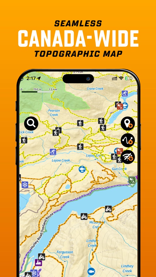
The BRMB Maps App is a one stop guide, allowing for safe and easy navigation into and out of the Canada’s backcountry:
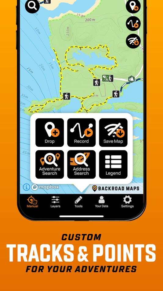
View your current location on the map and track your route
The fast, seamless map interface allows you so see all the roads, parks, and geographic features from the popular Backroad Mapbooks series across the entire country.
Reveal the lay of the land with topographic contours and relief shading
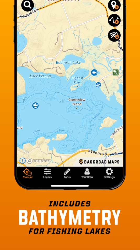
Explore lakes like never before with bathymetric (lake depths) contours
Zoom in and see all the logging, industrial and other roads not found on other maps
View on multiple devices, such as smartphone tablet or computer, with a single account
GET MORE WITH BRMB MAPS PRO
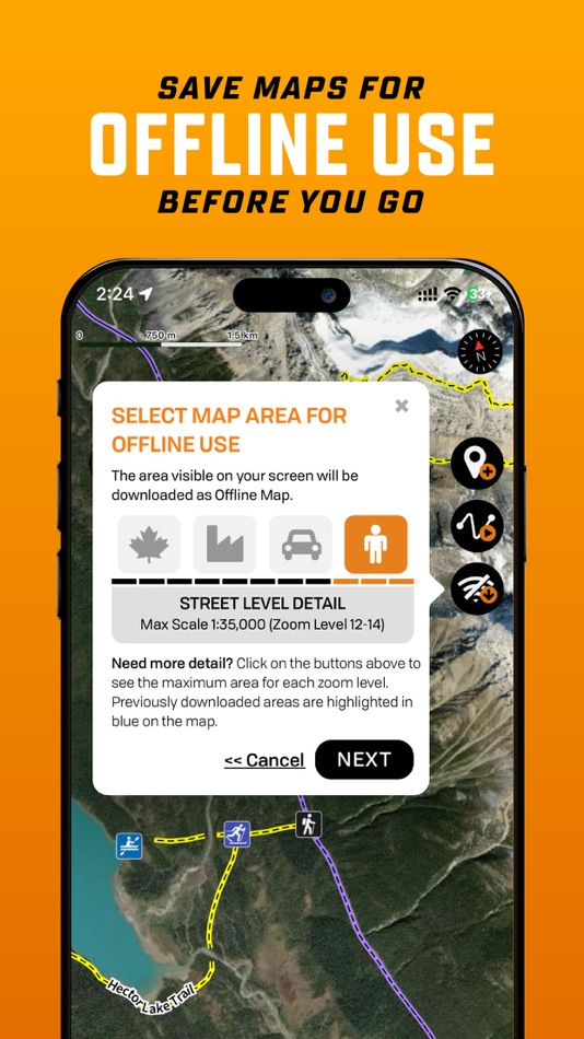
Download offline maps - track your exact GPS location as you navigate the trail, even when you don’t have a signal
Save All the info offline - even Point of Interest information & descriptions
Access current, high resolution satellite map imagery
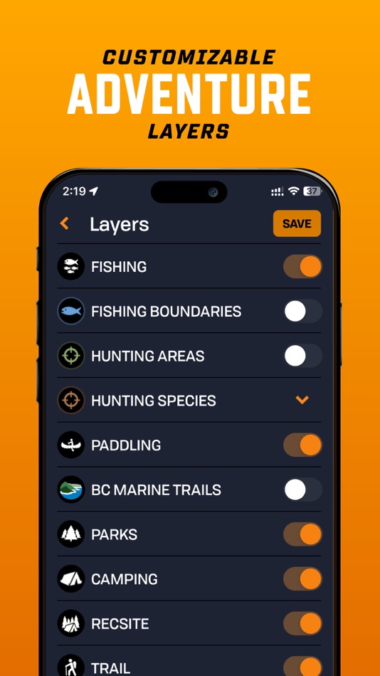
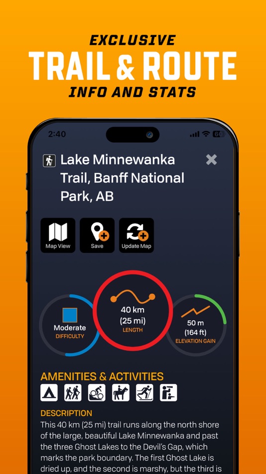
Adventure Layers revealing thousand’s of Points of Interest within each Adventure Layer providing descriptions, access, trail info, fish and hunt species, and so much more
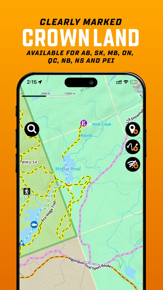
Access Crown Land and Private Land Layers
Access the Resource and Recreation Road layer to overlay on the satellite imagery
Record your Adventures & Save your Trips
Get access to the BRMBMAPS.COM website, where you can further plan your trips and explore on a bigger screen
Design and print custom topo maps through brmbmaps.com
Adventure Layers include:
Attractions
- Over 15,000 Attractions, Beaches, Caves, Ghost Towns, Hot Springs, Lighthouses, Museums, Waterfalls, and more
Fishing
- Over 20,000 Lake, River & Creek and Ocean Fishing areas
- Fish Zone Boundaries, Lake Bathymetry, Stocked Lakes, Marinas & Boat Launches
- Fishing descriptions with Species, Lake Stats & Regulation links
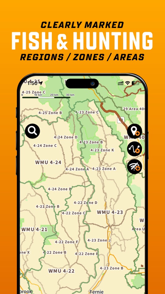
Hunting Areas
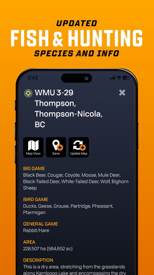
- Over 2,500 Management Units (WMU/WMZ, etc.), Species Specific Zones, and more
- Hunting descriptions with Species & Regulation links
Paddling Routes
- Almost 3,000 Paddling routes including Access Points & Portages
- Canoe & Kayak, Lake Circuits, River & Ocean Routes and Whitewater
Parks
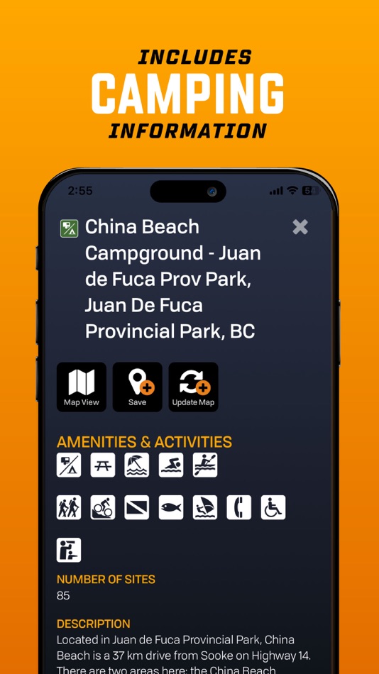
- Over 35,000 National, Provincial, Regional & Urban parks including Campsites, Picnic Areas, Backcountry Cabins, Conservation Areas, and more
Recreation Sites
- Over 1,300 sites listed with Activities, Size, RV or 4wd Access, and more
Trails
- Over 14,000 Trail tracks with Trailheads for Hiking, Biking, Equestrian, and more
- Trail descriptions including Difficulty, Length and Elevation Gain
ATV Trails
- Almost 1,700 trail tracks with Trailheads for ATV, OHV, Dirtbikes and Overlanding
Snowmobile Routes
- Over 2,250 trail tracks with Trailheads offering Club, Groomed & Backcountry Routes
Wildlife Viewing
- Over 1,750 sites for Birdwatching, Large & Small Animals, Whale Watching, and more
Winter Recreation
- Over 1,900 Trail tracks with Trailheads for Backcountry, Cross-Country & Nordic Skiing, Downhill Areas, and Snowshoeing
BRMB Maps PRO is only $3.49/mo. Payment will be charged to your iTunes account on confirmation. Subscriptions will automatically renew unless cancelled within 24-hours before the end of the current period.
You can turn-off auto-renewal in Settings: http://support.apple.com/kb/ht4098
Our Terms of Use: https://www.brmbmaps.com/terms-conditions
Our Privacy Policy: https://www.brmbmaps.com/privacy-policy
Screenshots
What's new
- Version: 2.4.0
- Updated:
- Version 2.4 includes a major update of all basemap and Adventure information, bringing in all of the changes and updates over the last year. The basemap has over 22,000 km of new and updated roads plus over 8,000 new land and water features. The Adventures includes over 20,000 km of new and updated ATV/Overland/Snowmobile, Multi-Use/Mountain Bike and Paddling Routes and Trails. There are also 5,400 new Adventure POI added. We were also able to fit in a new Quick Start track recording as well as new colour line styles to help differentiate the various recorded tracks by activity.
Version 2.4 Highlights:
- Includes hundreds of customer Map and POI Updates from the 30th Anniversary Contest
- Includes tens of thousands of km of new roads, thousands of km of new ATV and snowmobile routes, multi-use and bike trails, paddling routes and more.
- Includes over 8,000 new Land and Water features
- Includes almost 5,500 new Adventure POIs
- Enhanced Private/Crown Land, Industry/Rec Roads, Oil & Gas, Service Providers, Gas Stations and EV Charging Overlays
- Autofill date/time and activity to help start recording your tracks quicker
- Track lines are now coloured by outdoor activity to help you differentiate between your favourite activities
Version 2.4 Update Stats:
- 17,000+ km of various roads & highways
- 5,000 km of new or enhanced Logging Roads
- 10,000 km of additional ATV Trails
- 1,500 km of Overland Routes
- 650 km of new Snowmobile Trails
- 6,000 km of new and updated Multi-use Trails
- 250 km of new Mountain Bike Trails
- 2,000 km of new and enhanced Paddling Routes
- 8,000 new Land & Water features POIs
- 5,400 more Adventure POIs
Price
- Today: Free
- Minimum: Free
- Maximum: Free
Track prices
Developer
- Mussio Ventures Ltd.
- Platforms: iOS Apps (1)
- Lists: 0 + 0
- Points: 0 + 11 ¡
- Rankings: 0
- Reviews: 0
- Discounts: 0
- Videos: 0
- RSS: Subscribe
Points
Not found ☹️
Rankings
Not found ☹️
Lists
Not found ☹️
Reviews
Be the first to review!
Additional Information
- Category:
iOS Apps›Navigation - OS:
iPad,iPhone,iOS 13.0 and up - Size:
188 Mb - Supported Languages:
English - Content Rating:
4+ - App Store Rating:
4.1(11) - Updated:
- Release Date:
Contacts
- Website:
 https://www.brmbmaps.com/
You may also like
-
- 4WD Maps - Offline Topo Maps
- iOS Apps: Navigation By: Hema Maps
- $64.99
- Lists: 0 + 0 Rankings: 0 Reviews: 0
- Points: 0 + 4 Version: 2.4.2 Best value Hema App. The one-time cost includes all Hema 4WD maps, without any recurring subscriptions. Use offline mapping and your device s in-built GPS receiver to see where you are
-
- Maps 3D PRO - Hike & Bike
- iOS Apps: Navigation By: movingworld GmbH
- $3.99
- Lists: 1 + 4 Rankings: 0 Reviews: 0
- Points: 0 + 194 Version: 6.6 Enjoy exploring the great outdoors? If you re a fan of biking, hiking and running then Maps 3D is the ideal app designed for planning your outdoor adventures. Whereas other mapping ...
-
- Goose Maps for Watch
- iOS Apps: Navigation By: GOOSE MAPS LTD
- Free
- Lists: 0 + 0 Rankings: 0 Reviews: 0
- Points: 0 + 181 Version: 1.3 Features - Navigate easily everywhere Our pedestrian and bike navigation perfectly work even if your iPhone stayed at home. - Search objects you need Our search helps you to find ...
-
- Local Maps
- iOS Apps: Navigation By: Local Maps Inc
- Free
- Lists: 0 + 0 Rankings: 0 Reviews: 0
- Points: 0 + 4 Version: 1.3 Find the funnel cake stand or next horse race faster than ever before with this free and easy to use navigation platform for fairs and festivals. Start enjoying your time by finding ...
-
- Apple Maps
- iOS Apps: Navigation By: Apple
- Free
- Lists: 3 + 1 Rankings: 4 (1) Reviews: 0
- Points: 1 + 23,006 Version: 1.5 Maps Apple Maps is the best way to navigate and explore the world - all with your privacy protected. What s New: Multi-stop routing lets you add multiple stops along your driving route
-
- Google Maps
- iOS Apps: Navigation By: Google
- Free
- Lists: 13 + 6 Rankings: 5 (3) Reviews: 5 (1)
- Points: 5 + 5,879,662 Version: 6.113.0 Navigate your world faster and easier with Google Maps. Over 220 countries and territories mapped and hundreds of millions of businesses and places on the map. Get real-time GPS ...
-
- GPS Route Finder & Voice Maps
- iOS Apps: Navigation By: Mudassar Ahmed
- Free
- Lists: 0 + 0 Rankings: 0 Reviews: 0
- Points: 0 + 8 Version: 9.0 Get Turn by Turn GPS Driving Directions and Best Route to Your Destination with GPS Route Finder & Voice Maps Navigation App! GPS Route Finder & Voice MAPS is an easy to use GPS ...
-
- Bristol Maps
- iOS Apps: Navigation By: Chris Hager
- * Free
- Lists: 0 + 0 Rankings: 0 Reviews: 0
- Points: 0 + 2 Version: 2.05 Bristol Maps is designed specifically for commercial fishermen to navigate using the latest satellite imagery. Currently serving Bristol Bay and Copper River watersheds. Say goodbye to
-
- Wander: Maps & Navigation
- iOS Apps: Navigation By: Wander App Inc
- Free
- Lists: 0 + 0 Rankings: 0 Reviews: 0
- Points: 0 + 32 Version: 5.2.6 Wander is a global network of locally built maps. In the Wander App you'll find premium and official maps for large and small travel and recreation destinations. No more downloading an
-
- Yango Maps
- iOS Apps: Navigation By: Direct Cursus Computer Systems Trading
- Free
- Lists: 0 + 0 Rankings: 0 Reviews: 0
- Points: 0 + 102 Version: 18.0 Navigate the city easily, whether you're driving, walking, or using public transport. With our GPS-powered app, you can see your precise location and get convenient directions straight
-
- Petal Maps – GPS & Navigation
- iOS Apps: Navigation By: Huawei Software Technologies Co., Ltd.
- Free
- Lists: 0 + 0 Rankings: 0 Reviews: 0
- Points: 1 + 67 Version: 1.2.300 A new way to navigate Petal Maps lets you explore the world around you in new ways. Available in over 160 countries and regions, it not only lets you get your current location, browse ...
-
- York U Maps
- iOS Apps: Navigation By: YAN CHEN
- Free
- Lists: 1 + 0 Rankings: 0 Reviews: 0
- Points: 1 + 3 Version: 2.0 York U Maps is a navigation app for Keele campus of York University. You can search for buildings with their abbreviations, e.g. LAS for Lassonde Building, which are commonly used in ...
-
- Forest Maps 2
- iOS Apps: Navigation By: Kinnaman Software LLC
- Free
- Lists: 0 + 0 Rankings: 0 Reviews: 0
- Points: 0 + 476 Version: 2.7.2 Forest service maps on your iPhone or iPad! This app includes all areas mapped by the United States Forest Service. The map is a single, continuous map, so there's no need to search ...
-
- Avenza Maps: Offline Mapping
- iOS Apps: Navigation By: Avenza Systems Inc.
- * Free
- Lists: 0 + 0 Rankings: 0 Reviews: 0
- Points: 0 + 109,429 Version: 5.2.1 Avenza Maps, #1 app for hiking, biking and all trails. Featuring maps from National Geographic, national parks and more! On your next adventure, stay on track with GPS using offline ...