| Developer: | UK Weather Forecast (1) | ||
| Price: | $13.74 | ||
| Rankings: | 0 | ||
| Reviews: | 0 Write a Review | ||
| Lists: | 0 + 0 | ||
| Points: | 1 + 0 ¡ | ||
| Points + 1 | |||
Description
")
Access our forecast systems including will it thunder, will it be hot and plenty more information. Perfect if you love (or hate) thunderstorms and want to know if your exact location will get one.
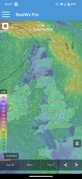
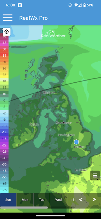
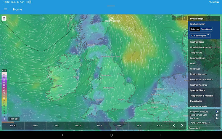
We also have the largest wealth of weather data in the form of interactive mapping, displaying hundreds of different variables from over 25 different weather models, including GFS, ECM, ICON, UKMO and UKV model data.
You also gain 12 months access to our Private Facebook group where you receive daily weather updates, long range forecasts, video forecasts, severe weather coverage and more!
A full list of interactive model data can be found below, you won't be disappointed!
Popular Maps
Wind Animation
Weather Radar
Clouds & Precipitation
Temperature
Sunshine Hours
Wind
Wind Gust
Relative Humidity
Precipitation Probability
Weather Warnings
Synoptic Charts
Sea Level Pressure
Pressure & 3h Tendency
Measured Temperature
Measured Precipitation
500 hPa Height
1000-500 hPa Thickness
Temperature & Height (GPH)
Jet Stream (250 hPa)
Temperature & Humidity
Apparent Temperature
Freezing Level Height (0°C)
Surface Inversion
Temperature Change (Next 24h)
Equivalent Potential (ThetaE)
Wetbulb Potential Temperature
Dewpoint Temperature
Vapor Pressure Deficit
Evapotranspiration
FAO evapotranspiration (ET0)
Potential Evapotranspiration
Soil Moisture
Soil Temperature
Precipitation
Accumulated Precipitation
Daily Precipitation
Hourly Precipitation
Accumulated Snowfall
Daily Snowfall
Hourly Snowfall
Snow Depth
Aviation & Clouds
METAR
Cloud Cover Total
Low Clouds (0-3.5 km)
Medium Clouds (3.5-8 km)
High Clouds (>8 km)
Cloud Altitude
Convective Cloud Altitude
Visibility
Wind Convergence (10 m)
Convective Updraft
Soaring Flight Distance
Soaring Index
Boundary Layer Height
Clear Air Turbulence (CAT)
In-Flight Icing
SIGMET
Sea & Surf
Wave Height
Wave Period
Wave Peak Period
Ocean Currents
Sea Water Salinity
Sea Ice Cover
Water Surface Temperature
Air Quality & Pollen
Air Quality (CAQI)
Desert Dust
Ozone
Aerosol Optical Depth
Particulate Matter
SOâ‚‚
NOâ‚‚
CO
Grass Pollen
Ragweed Pollen
Birch Pollen
Olive Pollen
Seasonal Forecast
Temperature Anomaly (2 m)
Temperature Anomaly (850 mb)
Precipitation Anomaly
Snow Depth Anomaly
Evapotranspiration Anomaly
Sea Level Pressure Anomaly
Wind Speed Anomaly
SST Anomaly (El Nino)
More Maps
CAPE & Lifted Index
Convective Inhibition (CIN)
Lifted Index
Storm Helicity (0-3 km)
Solar Radiation (GHI)
UV Index
Extreme Forecast
Screenshots


What's new
- Version: 1.1.0
- Updated:
- First release of application.
Price
- Today: $13.74
- Minimum: $13.74
- Maximum: $13.74
Track prices
Developer
- UK Weather Forecast
- Platforms: Android Apps (1)
- Lists: 0 + 0
- Points: 1 + 0 ¡
- Rankings: 0
- Reviews: 0
- Discounts: 0
- Videos: 0
- RSS: Subscribe
Points
")
Rankings
Not found ☹️
Lists
Not found ☹️
Reviews
Be the first to review!
Additional Information
- Category:
Android Apps›Weather - OS:
Android 5.0 and up - Size:
21 Mb - Content Rating:
Everyone - Google Play Rating:
0 - Updated:
- Release Date:
Contacts
- Website:
 https://www.realweather.co.uk
You may also like
-
- wX
- Android Apps: Weather By: Joshua Tee
- Free
- Lists: 0 + 0 Rankings: 0 Reviews: 0
- Points: 0 + 843 Version: 55877 wX is a free, no-ads, and open-source ( GNU GPLv3 ) advanced weather application that is geared towards storm chasers, meteorologists, and weather enthusiasts. NWS ( National Weather ...
-
- NBC4 Wx
- Android Apps: Weather By: Nexstar Digital (formerly Media General)
- * Free
- Lists: 0 + 0 Rankings: 0 Reviews: 0
- Points: 0 + 384 Version: 6.7.1.1170 NBC4 and Storm Team 4 are proud to announce an interactive, local weather app for Columbus, Ohio users of Android devices. Features: Highly responsive interactive map optimized for 3G ...
-
- WANE WX
- Android Apps: Weather By: Nexstar Digital (formerly Lin Media)
- * Free
- Lists: 0 + 0 Rankings: 0 Reviews: 0
- Points: 0 + 571 Version: 5.13.1300 Never let the weather catch you by surprise again. The trusted weather experts at Live Doppler 15 Fury Storm Team deliver Fort Wayne, Indiana's most accurate hour-by-hour forecast for ...
-
- Matt Rudkin Weather
- Android Apps: Weather By: Matthew Rudkin
- * Free
- Lists: 0 + 0 Rankings: 0 Reviews: 0
- Points: 0 + 209 Version: 6.7.1.1180 The most powerful, data-driven weather app from the best known Meteorologist in Northern Indiana & Southwest Michigan! The Matt Rudkin Weather app comes jam-packed with exclusive tools