| Developer: | Kernalite (3) | ||
| Price: | * * Free | ||
| Rankings: | 0 | ||
| Reviews: | 0 Write a Review | ||
| Lists: | 0 + 0 | ||
| Points: | 0 + 2,118 ¡ | ||
| Points + 1 | |||
Description
")
NAVIGATIONAL CHARTS
- United States charts provided by National Oceanic and Atmospheric Administration (NOAA)
- New Zealand charts provided by Land Information New Zealand (LINZ)
Chart types:
- NOAA Electronic Navigational Charts (ENC) (NOAA's newest and most powerful electronic charting product).
- NOAA classic charts (including Day, Red, Dusk, Night, and Gray versions).
- LINZ charts (available in Day, Dusk, and Night versions only currently)
ROUTE PLANNING TOOLS
-Route Plotting. Tap and hold on the map for one second to plot your waypoints. To form a route, continue to tap and hold on the map in different areas. Distance and bearing are conveniently calculated and displayed for each leg as you add, adjust, or remove waypoints.
-Travel Mode. Automatically centers the map on your current position as you move. Use travel mode to see how closely you are following your plotted route in real time!
-Route Leg Summary. A convenient view containing detailed information of each leg you have plotted, including start and end coordinates, distance, and bearing.
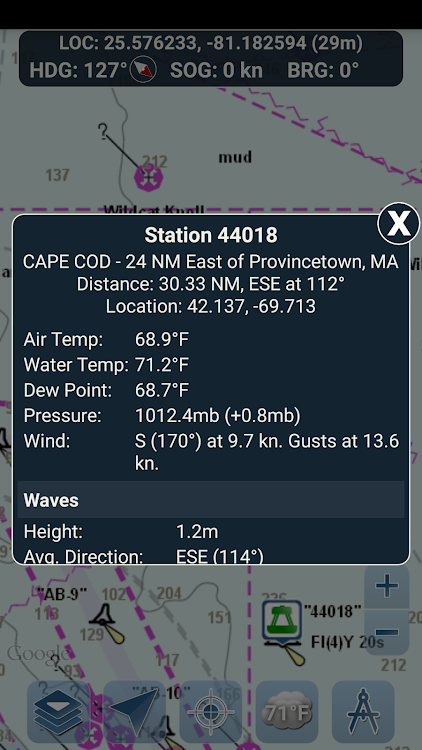
BUOY REPORTS AND OBSTRUCTION INFORMATION
Markers for buoys and obstructions are conveniently plotted in their actual location on the map! Just click on the marker to view their information!
- Buoy Reports: Get complete current conditions and wave reports for fixed and drifting buoys.
- Obstructions: Get location and history information about potentially dangerous, submerged hazards including rocks and sunken vessels.
NAVIGATION DASHBOARD
The navigational dashboard shows various real-time information including:
- Current location (latitude and longitude, with accuracy range)
- Current Heading (includes a small directional compass as well!)
- Current Speed Over Ground
- Current Bearing
MARINE MAP OVERLAYS
Toggle various marine overlay data right onto the map to get a better idea of the current boating conditions!
Overlays include:
- Water Surface Temperature (Global)
- Wind Speeds (US only)
- Wind Gusts (US only)
- Wave Heights (US only)
LOCATION SHARING OVER WATER / VIEW OTHER BOATS
- Display your last known location, speed, bearing, and boat name on the map for other Marine Ways boaters to view.
- View the last known location, speed, bearing, and boat name of other Marine Ways boaters, as well as their distance and bearing from your location.
- Location sharing is turned off by default. When you are ready to share, toggle it on within general settings. To continuously update your location on the map, keep the app opened and focused. The app currently does not update your location in the background.
WEATHER INFORMATION
- Weather Precipitation Radar (US & Hawaii only). Detects any rain and snow in the area.
- Weather Station. Reports the nearest observation station data. Current temperature, humidity, weather conditions, wind, and more! Station observation data is available globally.
- Weather Alerts. Weather station also reports any active weather alerts issued by the National Weather Service such as severe thunderstorm warnings or hurricane warnings. Weather alert information is available for US, Alaska and Hawaii.
- Land Surface Temperature overlay. Shows the current surface temperature on land (US only).
Before using this application, please read and agree to the following terms of use / service and privacy policy:
Terms of Use / Service: http://www.marineways.com/appterms
Privacy policy: http://www.marineways.com/appprivacy
Navigational Charts Disclaimer from NOAA:
NOAA ENC Online is not certified for navigation. Screen captures of the ENCs displayed here do NOT fulfill chart carriage requirements for regulated commercial vessels under Titles 33 and 46 of the Code of Federal Regulations.
Enjoy the app! Marine Ways is also available on the web at http://www.marineways.com
Screenshots


What's new
- Version: 1.34
- Updated:
- Misc adjustments and enhancements.
Price
-
*Contains Ads*In-App Purchases - Today: Free
- Minimum: Free
- Maximum: Free
Track prices
Developer
- Kernalite
- Platforms: Android Apps (3)
- Lists: 0 + 0
- Points: 0 + 3,405 ¡
- Rankings: 0
- Reviews: 0
- Discounts: 0
- Videos: 0
- RSS: Subscribe
Points
Not found ☹️
Rankings
Not found ☹️
Lists
Not found ☹️
Reviews
Be the first to review!
Additional Information
- Category:
Android Apps›Travel & Local - OS:
Android 4.4 and up - Size:
19 Mb - Content Rating:
Everyone - Google Play Rating:
4.6(2,118) - Updated:
- Release Date:
Contacts
- Website:
 http://www.marineways.com
You may also like
-
- Nautical Charts — OsmAnd
- Android Apps: Travel & Local By: OsmAnd
- Free
- Lists: 0 + 0 Rankings: 0 Reviews: 0
- Points: 0 + 2,148 Version: 1.0 Nautical Charts OsmAnd is an extension for OsmAnd Maps & Navigation app that provides free nautical charts for offline use. This sea map will be your reliable companion whether you are
-
- i-Boating:Marine Navigation
- Android Apps: Travel & Local By: Gps Nautical Charts
- * Free
- Lists: 0 + 0 Rankings: 0 Reviews: 0
- Points: 0 + 11,876 Version: 243.0 This Marine Charts App offers offline nautical charts, inland river navigation charts, and lake contour maps for fishing,kayaking, yachting & sailing. First marine navigation app to ...
-
- Nautical Info Service Croatia
- Android Apps: Travel & Local By: Ministarstvo pomorstva, prometa i infrastrukture
- Free
- Lists: 0 + 0 Rankings: 0 Reviews: 0
- Points: 0 + 410 Version: 1.2.7 Nautical Information Service (nIS) is a free multilingual application for smartphones, intended for owners of yachts and boats, fishermen, divers, swimmers and other people who spend ...
-
- MARLIN - Marine logbook
- Android Apps: Travel & Local By: MHNet Inc.
- * Free
- Lists: 0 + 0 Rankings: 0 Reviews: 0
- Points: 0 + 113 Version: 5.5.16 MARLIN is a social-based community platform that provides logbooks for various marine leisure activities such as scuba diving, free diving, surfing, mermaid diving, and ocean cleanup ...
-
- Sentinel - your boat, online
- Android Apps: Travel & Local By: Sentinel Marine solutions
- * Free
- Lists: 0 + 0 Rankings: 0 Reviews: 0
- Points: 2 + 54 Version: 6.4.3 Sentinel is designed for the owner of a boat to keep the cost of ownership low while maximizing security and comfort. Sentinel contstantly monitors your boat position and vital systems
-
- Live Camera
- Android Apps: Travel & Local By: Sigma-Marine
- * * Free
- Lists: 0 + 0 Rankings: 0 Reviews: 0
- Points: 0 + 6,824 Version: 4.9 Live Camera is a free app to see live cams video from thousands of public webcams nearby in the streets of your city and all around the world. See people in your city on live cams, ...
-
- Hazira Ghogha RoRo Ferry
- Android Apps: Travel & Local By: INDIGO SEA WAYS PVT LTD
- Free
- Lists: 0 + 0 Rankings: 0 Reviews: 0
- Points: 0 + 125 Version: 1.0.9 Indigo seaways Pvt. Ltd started India's first Roll On-Roll Off Ferry Service under the brand name DG Sea Connect - A Detox Group Company in the Gulf of Cambay. Booking website ...
-
- Nautics Sailmate Classic
- Android Apps: Travel & Local By: Nautics Oy
- * Free
- Lists: 0 + 0 Rankings: 0 Reviews: 0
- Points: 0 + 399 Version: 4.6.2 Nautics Sailmate is a Finnish navigation app for leisure boaters with the most reliable nautical charts on the market, provided by the Finnish Transport Agency. Sailmate offers ...
-
- LD-Log - GPS Tracker & Logbook
- Android Apps: Travel & Local By: A.Wedemeyer - Outdoor & Sailing Apps
- $8.90
- Lists: 0 + 0 Rankings: 0 Reviews: 0
- Points: 0 + 580 Version: 8.5.1 Multifunctional track logger for a wide range of uses Optimized for battery-efficient long-term tracking In-app travel diary / nautical logbook Maps and tools for outdoor navigation ...
-
- GPS Logger
- Android Apps: Travel & Local By: BasicAirData
- Free
- Lists: 0 + 0 Rankings: 0 Reviews: 0
- Points: 0 + 2,344 Version: New BasicAirData GPS Logger is a simple App for recording your position and your path. It's a basic and lightweight GPS tracker focused on accuracy, with an eye to power saving. It works ...
-
- Beachsafe
- Android Apps: Travel & Local By: Surf Life Saving Australia
- Free
- Lists: 0 + 0 Rankings: 0 Reviews: 0
- Points: 0 + 185 Version: 5.0.0 Taking a road trip up the coast? On holiday? Or just looking for the right beach for you? Find your nearest beaches in seconds. Brought to you by Surf Life Saving Australia, the ...
-
- Dubai UAE Gold Price Today
- Android Apps: Travel & Local By: KS Mobile Apps
- * Free
- Lists: 0 + 0 Rankings: 0 Reviews: 0
- Points: 0 + 679 Version: 5.5 Are you ready to embark on a golden journey towards financial prosperity? Stay on top of the latest gold rates in the UAE with our daily/ real-time updates. Our app provides you with ...
-
- Travel Expense Manager & Trip
- Android Apps: Travel & Local By: Evposli - Travel, Finance, Goals and Fitness apps
- * * Free
- Lists: 0 + 0 Rankings: 0 Reviews: 0
- Points: 0 + 355 Version: 5.0 A FREE travel expense manager - tracker, an essential tool for a budget traveler or digital nomad, to manage the travel budget in different currencies, to organize the entries ...
-
- OruxMaps GP
- Android Apps: Travel & Local By: jose vazquez
- * $4.49
- Lists: 2 + 2 Rankings: 0 Reviews: 0
- Points: 0 + 6,545 Version: New You can use OruxMaps for your outdoor activities. It is an Online and offline map viewer. With this app you can use different map formats, like GeoPDF from USGS store, GeoTIFF maps, ...