| Developer: | PixelProse SARL (9) | ||
| Price: | * * Free | ||
| Rankings: | 0 | ||
| Reviews: | 0 Write a Review | ||
| Lists: | 0 + 0 | ||
| Points: | 0 + 16,751 ¡ | ||
| Points + 1 | |||
Description
")
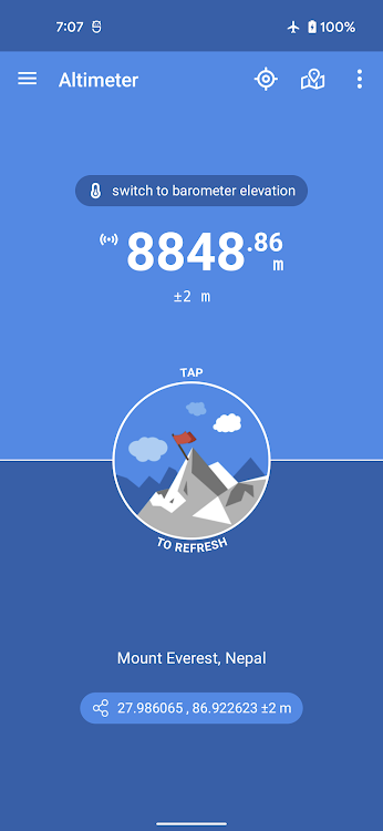
• Offline true altitude above sea level
• No network required (works offline and in flight mode)
• True altitude above sea level (AMSL using EGM96)
• Ordnance Survey National Grid reference system (OSGB36)
• Use Barometer or GPS Satellite
• Address at current location
• Save altitude at location
• Altitude accuracy estimation
• Horizontal accuracy estimation
• Altitude at any location
• Pick location on a Map
• Open photo geotags to display associated altitude
• Search for a location by name or address
• Universal Transverse Mercator coordinates (UTM)
• Military Grid Reference System coordinates (MGRS)
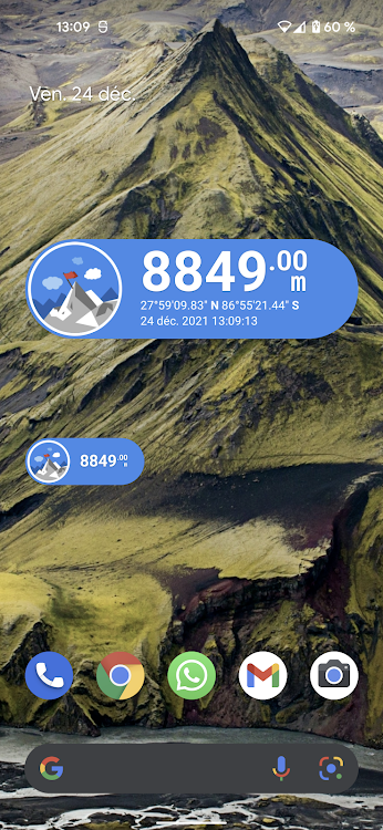
• Home screen widget to display altitude at current position
Network access is required to get the altitude of a location picked from the map.
Height above mean sea level (AMSL) is the elevation (on the ground) or altitude (in the air) of an object, relative to the average sea level datum. Normal GPS elevation considers the entire Earth as an ellispoid and differences up to 100 metres (328 feet) can exist between this ellipsoid height and true mean tidal height. The alternative, which is what we use in this application, is a geoid-based vertical datum such as the global EGM96 model.
Altitude vertical accuracy is defined at 68% confidence. Specifically, as 1-side of the 2-sided range above and below the estimated altitude reported, within which there is a 68% probability of finding the true altitude.
Enjoy!
Screenshots


What's new
- Version: 4.2.1
- Updated:
- Fixing the issue of retrieving altitude from the map
Price
-
*Contains Ads*In-App Purchases - Today: Free
- Minimum: Free
- Maximum: Free
Track prices
Developer
- PixelProse SARL
- Platforms: Android Apps (8) Android Games (1)
- Lists: 0 + 0
- Points: 4 + 458,902 ¡
- Rankings: 0
- Reviews: 0
- Discounts: 0
- Videos: 0
- RSS: Subscribe
Points
Not found ☹️
Rankings
Not found ☹️
Lists
Not found ☹️
Reviews
Be the first to review!
Additional Information
- Category:
Android Apps›Tools - OS:
Android 5.0 and up - Size:
21 Mb - Content Rating:
Everyone - Google Play Rating:
4.6(16,751) - Updated:
- Release Date:
Contacts
- Website:
 https://www.pixelprose.fr
You may also like
-
- Altimeter
- Android Apps: Tools By: EXA Tools
- * * Free
- Lists: 0 + 0 Rankings: 0 Reviews: 0
- Points: 0 + 21,186 Version: 5.0.01 Altimeter is a smart tracking devices, used to altitude measure. It is perfect app for people who love hiking, skiing, mountain biking and other outdoor activities. Any time and with ...
-
- Altimeter & Altitude Widget
- Android Apps: Tools By: Disciple Skies Software
- * * Free
- Lists: 0 + 0 Rankings: 0 Reviews: 0
- Points: 0 + 20,185 Version: 4.62 DS Altimeter is an elevation meter, elevation logger, and altitude mapper. In addition to showing and optionally tracking your altitude, the app allows you to search the altitude for ...
-
- Altimeter professional
- Android Apps: Tools By: FFZ srl
- * * Free
- Lists: 0 + 0 Rankings: 0 Reviews: 0
- Points: 0 + 55,507 Version: 4.9.8 The professional altimeter with automatic altitude detection that works even without an internet connection! With the professional altimeter application you will be able to know the ...
-
- Smart Altimeter - GPS Altitude
- Android Apps: Tools By: Go Get International LLC
- * * Free
- Lists: 0 + 0 Rankings: 0 Reviews: 0
- Points: 0 + 9,202 Version: 18.0 Looking for a reliable and accurate way to track your elevation during your outdoor adventures? Look no further than the Smart Altimeter! Whether you're hiking, climbing, land area, ...
-
- Compass & Altimeter
- Android Apps: Tools By: PixelProse SARL
- * Free
- Lists: 0 + 0 Rankings: 0 Reviews: 0
- Points: 0 + 110,156 Version: 3.6.4 A simple and easy to use Compass to retrieve useful information about your current position such as true Geographic north and true altitude above sea level. Works perfectly offline and
-
- GPS Tools® -Navigate & Explore
- Android Apps: Tools By: VirtualMaze
- * * Free
- Lists: 0 + 0 Rankings: 0 Reviews: 0
- Points: 0 + 135,874 Version: 3.3.3.9 Have you ever got stuck on road without accurate GPS location? Have you ever needed all GPS based tools in one app? Get GPS Tools, all-in-one GPS app which includes location tagging, ...
-
- Tool Box
- Android Apps: Tools By: MAXCOM
- * Free
- Lists: 0 + 0 Rankings: 0 Reviews: 0
- Points: 0 + 11,024 Version: 1.9.1.AF It is a tool package application that implements tools useful in daily life using the hardware and sensors of the handset. The toolbox consists of a total of 27 essential tools, and ...
-
- GPS Test
- Android Apps: Tools By: Chartcross Limited
- * Free
- Lists: 0 + 0 Rankings: 0 Reviews: 0
- Points: 1 + 70,552 Version: 1.6.4 With this app, you can check the GPS reception in your area and update AGPS data for faster fix times, whilst being able to view other GPS and sensor data. The app acts as a one-stop ...
-
- Perfect Compass (with weather)
- Android Apps: Tools By: Cards
- * * Free
- Lists: 0 + 0 Rankings: 0 Reviews: 0
- Points: 0 + 30,460 Version: 8.11.1 Discover the power of the compass app - the ultimate navigation companion. With this free offline compass, you will always find the right course no matter where you are. All you need ...
-
- Sensors Multitool
- Android Apps: Tools By: Wered Software
- * Free
- Lists: 0 + 0 Rankings: 0 Reviews: 0
- Points: 0 + 10,525 Version: 1.4.0 Sensors Multitool: the ultimate tool for monitor all the sensors of your smartphone. Information about all sensors supported by your phone Support for show information of WIFI networks
-
- Smart Tools - All In One
- Android Apps: Tools By: PC Mehanik
- * * Free
- Lists: 0 + 0 Rankings: 0 Reviews: 0
- Points: 0 + 11,496 Version: 20.9 Smart Tools - All In One is a useful kit of tools with 40+ carpenter, construction, measure and other tools and utilities. Use device's in-built sensors in all in one tool box app, ...
-
- Sensors Toolbox
- Android Apps: Tools By: CA40
- * * Free
- Lists: 0 + 0 Rankings: 0 Reviews: 0
- Points: 1 + 13,396 Version: 1.7.01 Sensors toolbox is the absolute all-in-one diagnostic tool that lets you know virtually everything about your mobile device status. Get full information about all sensors supported by ...