| ผู้พัฒนา: | Erol1Apps (2) | ||
| ราคา: | * * ฟรี | ||
| การจัดอันดับ: | 0 | ||
| ความเห็น: | 0 เขียนความเห็น | ||
| รายการ: | 0 + 0 | ||
| แต้มแล: | 0 + 2,715 ¡ | ||
| แต้มแล + 1 | |||
คำอธิบาย
")
Download the ultimate activity tool today!
ALT-LAS Can be used as a Bike computer use it on your bike, bicycle, scooter, and more!
By using the app you can get:
1. Elevation finder and activity tracker.
2. The app has a unique database of many trails around the world that was recorded by the users so you get the best hiking trails.
3. The app finds your altitude, peak points, barometric pressure, speed, and more!
4. The app alerts you against altitude limitations and is suitable for a variety of activities such as Walking, Trekking, Flights, Cycling, Skiing, biking, and more.
Have you ever searched for "walks near me?" or find elevation? now you can get it immediately with ALT-LAS.
Help build a community that shares routes and places around the world.
Measuring altitude modes:
1. GPS mode: the application measures the altitude using the GPS and performs a unique correction to provide an accurate altitude.
Note, that the altitude readings may be inaccurate when the GPS signal is weak.
2. Barometer sensor (a device with a barometer sensor): the application can work with the device’s barometer sensor that is auto-calibrated with the environment.
In this mode, the application can work inside buildings without GPS.
Features:
- Track activities
- Trail navigation
- Explore new trails
- Offline maps (Pro version)
- View Trails in 3D (Pro version)
- Track your elevation
- Altimeter to get your current altitude.
- Discover and share tracks
- Weather forecast
- Elevation map
- Compass with lock bearing
- Steps & Calories calculator
- Share live location (Subscription only)
- Real-time altitude graph
- Altitude limit alerts
- Save landmarks
- Barometric pressure
- Import/export GPX files
- Climbing information
- The Altimeter can work offline (flight mode)
- Get indoor/outdoors altitude
- Periodic altitude voice notification
- Different map types: Topographic, Open Street Map, hike & bike, and Satellite (Premium only).
- Sensor info (Supported devices only) such as Barometer, Temperature, Light, and Humidity.
- Dark mode
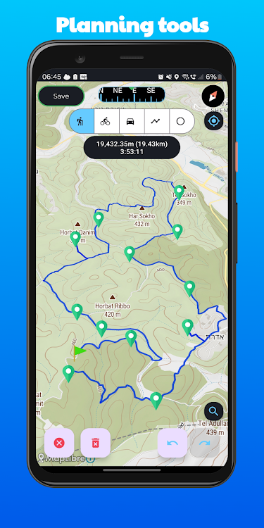
Planning and Navigation tools:
- Measure route and vertical distance
- Routing: get the fastest route between any location to another.
- Get coordinates on the map
- Estimate time of arrival
- Circular boundary
SUPPORT:
For any questions or suggestions, feel free to contact us:
Check the Telegram channel where you can ask questions, and ideas, request features, share your activities, and more: https://t.me/ALTLASAPP
User Manual & FAQ
https://altlas-app.com/support.html
Customer support:
erol1apps@gmail.com
Website:
www.altlas-app.com
Download the app now and get started!
The use of this app or any of its content is at your own risk.
If you liked the app, please rate it!
ภาพหน้าจอ


มีอะไรใหม่
- เวอร์ชัน: 5.0.8
- อัปเดต:
- 1. You now possess the flexibility to tailor your subscription type to precisely match your unique requirements.
2. Enhanced the user interface and color palette.
3. Rendering trail plans in 3D.
4. Historical trails now display visible points along the route.
5. Bug fixes.
ราคา
-
*มีโฆษณา*การซื้อภายในแอพ - วันนี้: ฟรี
- ต่ำสุด: ฟรี
- มากที่สุด: ฟรี
ติดตามราคา
ผู้พัฒนา
- Erol1Apps
- แพลตฟอร์ม: Android แอป (2)
- รายการ: 0 + 0
- แต้มแล: 0 + 2,715 ¡
- การจัดอันดับ: 0
- ความเห็น: 0
- ลดราคา: 0
- วิดีโอ: 0
- RSS: ติดตาม
แต้มแล
ไม่พบ ☹️
การจัดอันดับ
ไม่พบ ☹️
รายการ
ไม่พบ ☹️
ความเห็น
แสดงรีวิวเป็นคนแรกเลย!
ข้อมูลเพิ่มเติม
- หมวดหมู่:
Android แอป›แผนที่และการนำทาง - ระบบปฏิบัติการ:
Android 7.1 และสูงกว่า - ขนาด:
25 Mb - การจัดประเภทเนื้อหา:
Everyone - Google Play คะแนนโดย:
4.3(2,715) - อัปเดต:
- วันที่วางจำหน่าย:
รายชื่อติดต่อ
- เว็บไซท์:
 https://altlas-app.com
คุณอาจชอบ
-
- Organic Maps: Hike Bike Drive
- Android แอป: แผนที่และการนำทาง โดย: Organic Maps
- ฟรี
- รายการ: 0 + 0 การจัดอันดับ: 0 ความเห็น: 0
- แต้มแล: 2 + 8,205 เวอร์ชัน: 2024.03.31-8-Google Our free app does not track you, does not have ads, and it needs your support. It is constantly being improved by contributors and our small team, in our free time. If something is ...
-
- Maps Distance Calculator
- Android แอป: แผนที่และการนำทาง โดย: Maps Distance Calculator
- * ฟรี
- รายการ: 0 + 0 การจัดอันดับ: 0 ความเห็น: 0
- แต้มแล: 1 + 6,676 เวอร์ชัน: 1.2.4 Maps Distance Calculator - Directions & Distance Between Cities is good the application for get direction on maps and calculate distance between two cities or 2 any points. You only ...
-
- Trails Offroad
- Android แอป: แผนที่และการนำทาง โดย: Trails Offroad
- * ฟรี
- รายการ: 0 + 0 การจัดอันดับ: 0 ความเห็น: 0
- แต้มแล: 0 + 112 เวอร์ชัน: 2.8.3_535 Discover the ultimate off-road trail experience with Trails Offroad, your essential guide to exploring the great outdoors. Whether you're into 4x4, Jeep, Bronco, ATV, or Overlanding ...
-
- Hike - Affordable & Safe Rides
- Android แอป: แผนที่และการนำทาง โดย: Hike Technologies (Pty) Ltd
- ฟรี
- รายการ: 0 + 0 การจัดอันดับ: 0 ความเห็น: 0
- แต้มแล: 0 + 75 เวอร์ชัน: 1.0.255 Welcome to our Hike app, the smart way to get around town! With just a few taps on your phone, you can request a ride and be on your way in minutes. Our app connects you with nearby ...
-
- Maps: GPS Navigation, location
- Android แอป: แผนที่และการนำทาง โดย: Satellite World Maps
- * * ฟรี
- รายการ: 0 + 0 การจัดอันดับ: 0 ความเห็น: 0
- แต้มแล: 0 + 185 เวอร์ชัน: 1.7 By using the driving directions and earth map app, you can find the quickest routes and directions to any location on earth. Without the proper street view app, it is never simple to ...
-
- Maps, Navigation & Directions
- Android แอป: แผนที่และการนำทาง โดย: Universal Nav
- * ฟรี
- รายการ: 0 + 0 การจัดอันดับ: 0 ความเห็น: 0
- แต้มแล: 1 + 12,845 เวอร์ชัน: 1.44 Maps, Navigation & Directions Free app have many useful features like offline Streets View, Digital Compass and Altimeter, Speedometer and Sensors, Offline Weather and UV Index, ...
-
- Better Maps. GPS navigation. M
- Android แอป: แผนที่และการนำทาง โดย: We love maps
- * ฟรี
- รายการ: 0 + 0 การจัดอันดับ: 0 ความเห็น: 0
- แต้มแล: 0 + 13,769 เวอร์ชัน: 4.03 Finally, a highly detailed map app for all countries and cities! More accurate than any other map apps in the store. Get access to free, worldwide and detailed, high-quality ...
-
- Maps, GPS Navigation, route
- Android แอป: แผนที่และการนำทาง โดย: Navigation Apps Tech
- * ฟรี
- รายการ: 0 + 0 การจัดอันดับ: 0 ความเห็น: 0
- แต้มแล: 0 + 927 เวอร์ชัน: 2.0.15 Maps, GPS Navigation, voice navigation, Directions is latest voice GPS and driving app application offers the alternative routes plus the shortest routes for your destination just like
-
- Maps GPS: Navigation, Traffic
- Android แอป: แผนที่และการนำทาง โดย: AppsMedia Inc
- * * ฟรี
- รายการ: 0 + 0 การจัดอันดับ: 0 ความเห็น: 0
- แต้มแล: 0 + 3,073 เวอร์ชัน: 1.4.10 Maps: Navigation, Traffic -Drive to any destination with Maps Plus Navigation, a powerhouse of an app that acts as your driving partner every time you travel by road. Everything that ...
-
- Maps Driving Directions
- Android แอป: แผนที่และการนำทาง โดย: APPSZONE
- * ฟรี
- รายการ: 0 + 0 การจัดอันดับ: 0 ความเห็น: 0
- แต้มแล: 2 + 5,120 เวอร์ชัน: 8.4.5 Are you looking for current location traffic on maps Driving Directions? ⤴️ ️ Do you need maps driving directions app to get to your desired place without having an internet ...
-
- Maps Explorer: old maps
- Android แอป: แผนที่และการนำทาง โดย: MDevs.
- * * ฟรี
- รายการ: 0 + 0 การจัดอันดับ: 0 ความเห็น: 0
- แต้มแล: 0 + 1,130 เวอร์ชัน: 1.2.8 It often happens that you have old historical maps, but when comparing them with a modern map, difficulties arise. Settlements grow or disappear altogether, roads change and it becomes
-
- Maps All in One, Speedometer
- Android แอป: แผนที่และการนำทาง โดย: duff hl studio
- * * ฟรี
- รายการ: 0 + 0 การจัดอันดับ: 0 ความเห็น: 0
- แต้มแล: 0 + 25,777 เวอร์ชัน: 2.9 Let's plan your trip in advance to navigate and explore routes for a trip with Maps All in One, Speedometer App. You can find out the location and direction of gas stations, ...
-
- Maps, GPS & Driving Directions
- Android แอป: แผนที่และการนำทาง โดย: Appsence Technologies CO., LTD
- * * ฟรี
- รายการ: 0 + 0 การจัดอันดับ: 0 ความเห็น: 0
- แต้มแล: 0 + 3,802 เวอร์ชัน: 1.47 GPS, Maps, Directions & Voice Navigation is a simple and reliable maps application where you can find best and traffic free Driving Directions, GPS Navigation, Live Maps, Street View, ...
-
- USA GPS Maps & My Navigation
- Android แอป: แผนที่และการนำทาง โดย: Navegante Maps
- * ฟรี
- รายการ: 0 + 0 การจัดอันดับ: 0 ความเห็น: 0
- แต้มแล: 0 + 11,225 เวอร์ชัน: 4.02 Over 2+ millions downloads. The easiest and fastest GPS Map App ever. All cities and streets of the world. All in one Map; GPS, Maps, Location, Geodir, Save, Share, Navigation, ...