| Developer: | Pocket Mariner Ltd. (12) | ||
| Price: | * Free | ||
| Rankings: | 0 | ||
| Reviews: | 0 Write a Review | ||
| Lists: | 0 + 0 | ||
| Points: | 0 + 185 ¡ | ||
| Points + 1 | |||
Description
")
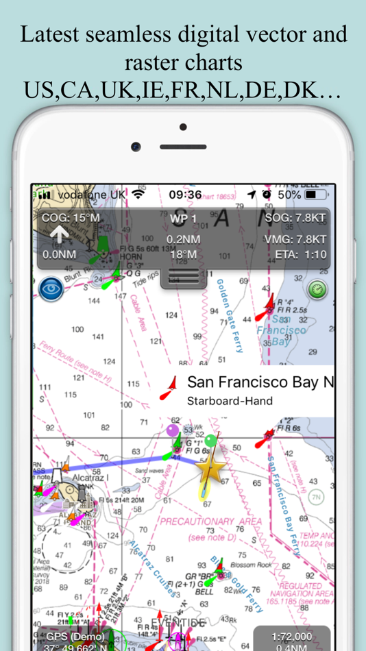
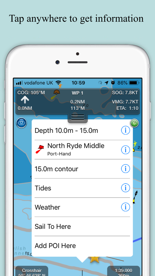
- Vector charts - all buoys, lights etc. are tappable
- Seamless fast panning and zoom across charts
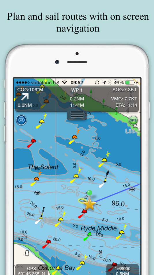
- Route Planning and real-time tracking
- North up and course up displays
- Offline charts
- Configurable layers
- Built-in tutorial mode with full features including charts, AIS, AR & wind
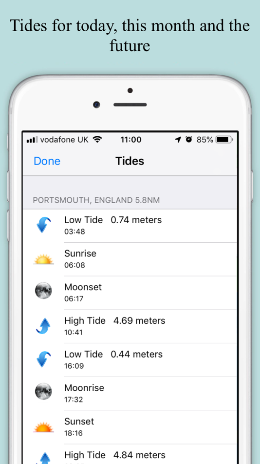
- Tides, Streams & Weather
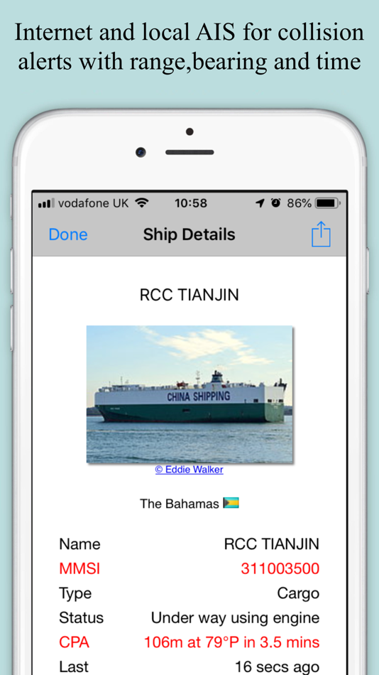
- Live AIS Ship positions and collision alarm (IAP)
- Import and share routes and POIs in GPX and KML formats via email and Dropbox
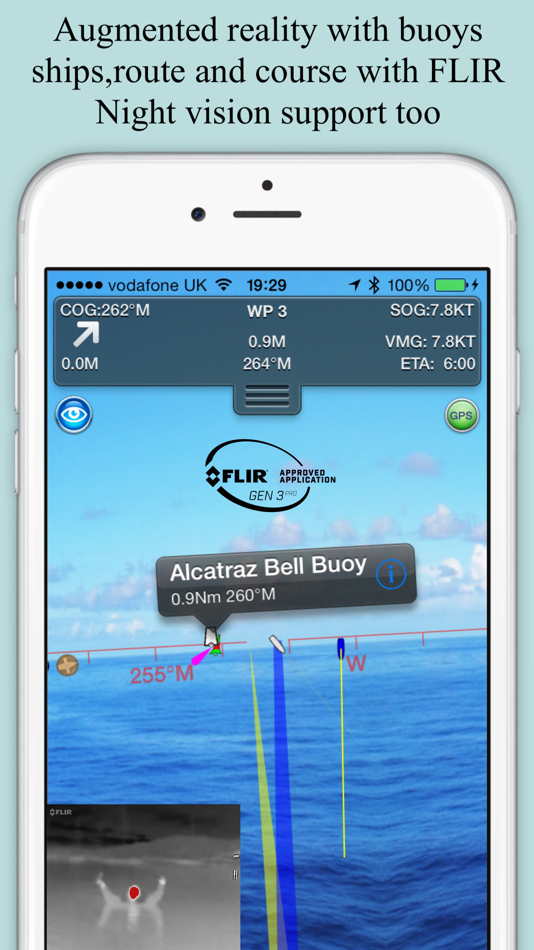
- Live Augmented Reality camera view (IAP) plus FLIRONE® night vision support.
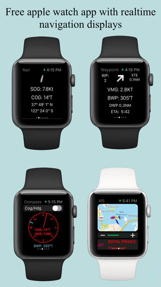
- Includes free Apple Watch app with Nav,Waypoint,Wind,AIS faces.
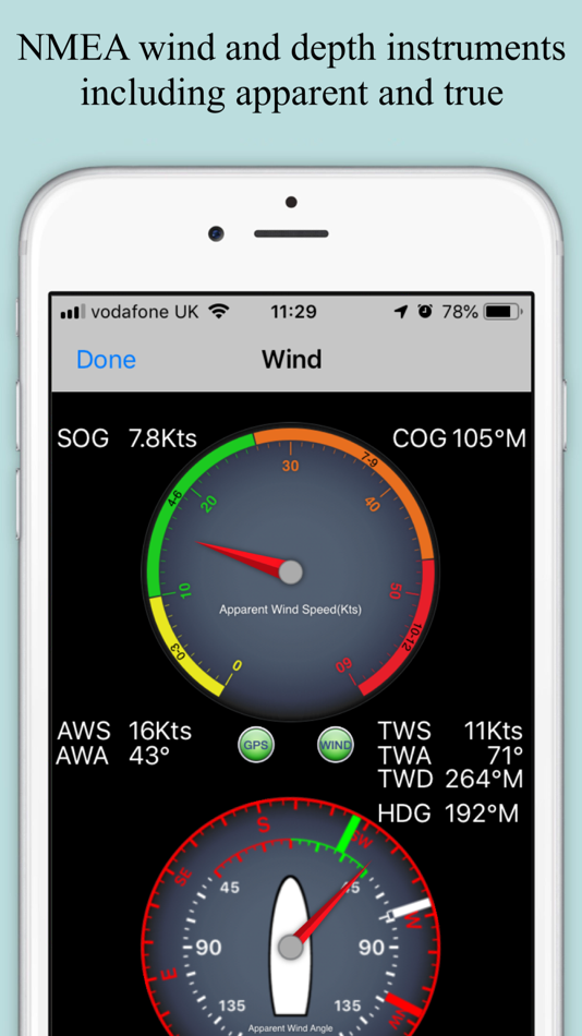
- NMEA Depth, Wind Speed and Direction
- Real time local wind feed (IAP)
The free version includes all navigation and trip planning tools. High resolution vector charts are available by In App Purchase (IAP) including updates for 12 months.
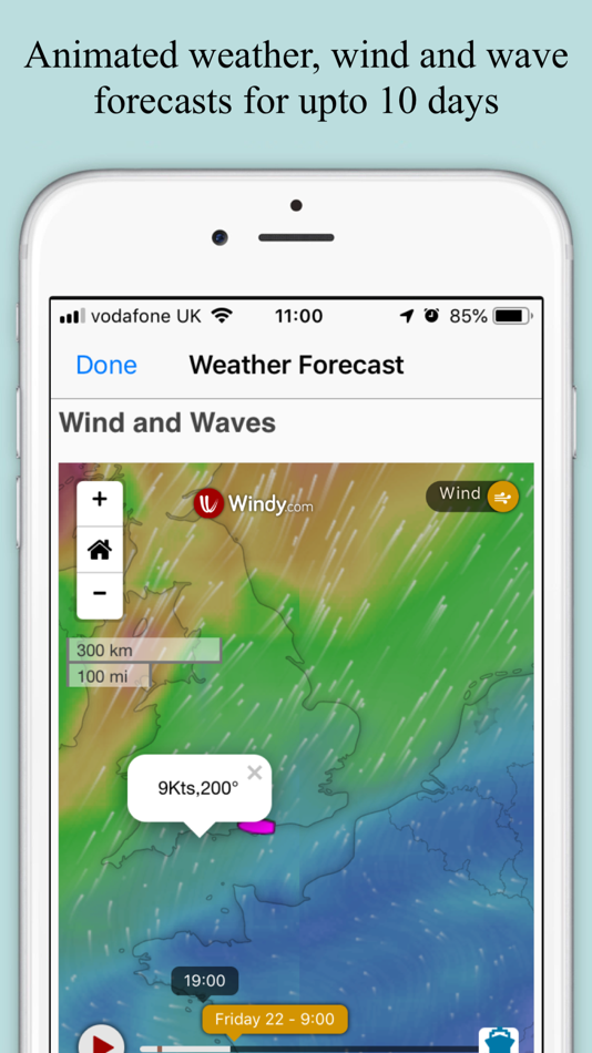
Vector charts provide many advantages over traditional raster charts. Buoys, Lights, Bridges, Depth Contours, Depth Soundings, Rocks, Anchorage areas, NOAA Weather Buoys etc. are all selectable and have real time distance, bearing and detail information. Turn off layers to de-clutter the display and only show what is important at the time. Tides, moon and sun times and weather are also all available at your fingertips.
In-app tools let you measure distances and bearings and record waypoints on routes to sail. When you are out at sea, the app’s Sailing HUD shows your position on the route, Course over ground (COG), Speed over ground (SOG), Vector Made Good (VMG), Estimated Time of Arrival (ETA), Distance and bearing to next Waypoint. Waypoint reached alerts, auto-routing to the next waypoint and flashing collision alerts (with AIS).
Unique AR view mode (IAP) allows you to view buoys, lights, ships, waypoints, route and track overlaid on your iPhone or iPad live camera view. With "AR LockOn" you can select a target on the chart and then be guided to it in the AR camera view. You can also see at night and in the fog with the FLIRONE Infra-red camera.
External NMEA GPS, AIS and Wind data over Wifi.
Requirements:
GPS only required for real time route navigation. Optional Real time AIS, Tides and Weather information require an active internet connection.
WiFi-only iPad or iPods will need an external GPS receiver for navigation.
Please note that continued use of GPS running in the background can dramatically decrease battery life.
Subscriptions
Our in-app purchases are 1 year subscriptions, which automatically renew at the end of the subscription period unless auto-renew is turned off at least 24-hours before the end of the current period. Payment will be charged to your iTunes Account at confirmation of purchase, and will be charged for renewal within 24-hours prior to the end of the current period. Pricing for our 1 year US Charts update subscription is $19.99.
Subscriptions may be managed by the iTunes account holder and auto-renewal may be turned off by going to Account Settings after purchase. No cancellation of the current subscription is allowed during active subscription period.
NOTICES: This product has been derived in part from material obtained from the UK Hydrographic Office with the permission of the UK Hydrographic Office, Her Majesty’s Stationery Office.” “© British Crown Copyright, [2012]. All rights reserved.
The UK Hydrographic Office (UKHO) and its licensors make no warranties or representations, express or implied, with respect to this product. The UKHO and its licensors have not verified the information within this product or quality assured it.
Terms of Use: http://seanav.net/termsofuse.php
Privacy Policy: http://seanav.net/privacy.php
Support: help@pocketmariner.com
Screenshots

What's new
- Version: 5.4.6
- Updated:
- Fixes and Updates for latest iPad iOS support.
Price : SeaNav
-
*In-App Purchases - Today: Free
- Minimum: Free
- Maximum: Free
Track prices
Developer
- Pocket Mariner Ltd.
- Platforms: iOS Apps (8) macOS Apps (4)
- Lists: 1 + 0
- Points: 1 + 3,333 ¡
- Rankings: 0
- Reviews: 0
- Discounts: 0
- Videos: 0
- RSS: Subscribe
Points
Not found ☹️
Rankings
Not found ☹️
Lists
Not found ☹️
Reviews
Be the first to review!
Additional Information : SeaNav
- Category:
iOS Apps›Navigation - OS:
Apple Watch,iPad,iPhone,iOS 11.0 and up - Size:
73 Mb - Supported Languages:
Danish,English,French,German,Spanish - Content Rating:
4+ - App Store Rating:
4.3(185) - Updated:
- Release Date:
Contacts
- Website:
 http://pocketmariner.com
You may also like
-
- Sea Drive: Charts, Nav, Routes
- iOS Apps: Navigation By: Sea Drive, LLC
- * Free
- Lists: 0 + 0 Rankings: 0 Reviews: 0
- Points: 0 + 133 Version: 13.0.0 * What is Sea Drive? Sea Drive is a marine and boating application focused on charting, navigation, route building, track recording, tides, currents, and more! Our goal is to provide ...
-
- Nav Camera
- iOS Apps: Navigation By: Craig Hunter
- $3.99
- Lists: 0 + 0 Rankings: 0 Reviews: 0
- Points: 0 + 33 Version: 1.2.3 Nav Camera uses the proven navigation, augmented reality, and image processing engines from the well known Theodolite app to create a new app that focuses on photogaphy and video ...
-
- Nav Trainer Pro
- iOS Apps: Navigation By: FLEMINGER MEDIA LLC
- $8.99
- Lists: 0 + 0 Rankings: 0 Reviews: 0
- Points: 0 + 35 Version: 3.5.0 Selected by AOPA.org readers as number one of five aviation apps you can't live without! * Reached No. 4 in the Navigation category of the U.S. app store for iPad! Make IFR flight ...
-
- RT-Nav
- iOS Apps: Navigation By: Hilton's Fishing Charts, L.L.C.
- Free
- Lists: 0 + 0 Rankings: 0 Reviews: 0
- Points: 0 + 7 Version: 1.0743 Hilton's Realtime-Navigator Mobile Navigation Application. Navigate on almost real-time imageries such as sea surface temperatures, chlorophyll, surface currents, altimetry, and ...
-
- Tactical NAV
- iOS Apps: Navigation By: TacNav Systems LLC
- * $8.99
- Lists: 0 + 0 Rankings: 0 Reviews: 0
- Points: 0 + 279 Version: 4.2.0 BACKGROUND: Built from the ground up in the rugged mountains of eastern Afghanistan, Tactical NAV was created by a U.S. Army Field Artillery officer with the vision of crafting a ...
-
- Celestial Nav
- iOS Apps: Navigation By: Skytip LLC
- * Free
- Lists: 0 + 0 Rankings: 0 Reviews: 0
- Points: 0 + 7 Version: 3.1 Celestial Nav is an easy to use, all-in-one tool which offers: Celestial navigational computations for your device Simple toolbar menu for quick access Internally stored perpetual ...
-
- Seasy - Making Sea Life Easy
- iOS Apps: Navigation By: Seasy GmbH
- Free
- Lists: 0 + 0 Rankings: 0 Reviews: 0
- Points: 1 + 5 Version: 1.4.5 With Seasy, you can book marinas in Croatia, Italy, Greece, Spain, Turkey, France, Portugal, Slovenia, Montenegro, and more from the comfort of your yacht, without any additional ...
-
- Karta GPS - Offline Maps Nav
- iOS Apps: Navigation By: Karta
- * Free
- Lists: 0 + 0 Rankings: 0 Reviews: 0
- Points: 0 + 1,763 Version: 2.46.06 "Get to your destination. Bigly." - Huffington Post "it s damn good at finding tacos." - The Next Web Free, offline, content-rich maps that allow you to explore new places and drive ...
-
- Pumpout Nav
- iOS Apps: Navigation By: ecom enterprises, inc.
- Free
- Lists: 0 + 0 Rankings: 0 Reviews: 0
- Points: 0 + 39 Version: 4.7.0 Marina Pumpout Finder available in select regions of California, Oregon, Washington, Florida and in the Lake Champlain area of Vermont and New York. Find the closest sewage pumpout ...
-
- SeaHelp
- iOS Apps: Navigation By: Sea-Help GmbH
- Free
- Lists: 0 + 0 Rankings: 0 Reviews: 0
- Points: 0 + 27 Version: 6.60 SeaHelp the breakdown service at sea With this kind of service, SeaHelp App is offering to all skippers the possibilty of asking for professional help on short notice in breakdown or ...
-
- Sygic Truck & RV Navigation
- iOS Apps: Navigation By: Sygic a. s.
- * Free
- Lists: 0 + 0 Rankings: 0 Reviews: 0
- Points: 1 + 2,017 Version: 24.0.1 High-quality GPS navigation designed for professional drivers & their large vehicles. Trusted by 5+ million drivers & many of the world's leading delivery fleets. Smart route planning ...
-
- Altimeter: Elevation, Compass
- iOS Apps: Navigation By: Furkan Ozoglu
- Free
- Lists: 0 + 0 Rankings: 0 Reviews: 0
- Points: 0 + 934 Version: 2.0.3 While traveling with a vehicle (car, bicycle, etc.), while hiking or climbing, you can instantly discover your location and altitude, direction, geographic coordinate, address and ...
-
- Location Changer Converter App
- iOS Apps: Navigation By: Ikbal Yasar
- * Free
- Lists: 0 + 0 Rankings: 0 Reviews: 0
- Points: 1 + 12 Version: 1.4.3 Location: Your Comprehensive Location and Orientation Companion Discover the power of myLocation, a user-friendly tool designed to simplify location search and sharing. With just a few
-
- Elevation - Altimeter Map
- iOS Apps: Navigation By: Mapnitude Company Limited
- * Free
- Lists: 0 + 1 Rankings: 0 Reviews: 0
- Points: 0 + 4,328 Version: 4.9.14 Find your current elevation, altitude, and height above sea level easily with this altimeter/barometer app. ## Elevation Finder ## This app helps you observe the elevations of all ...