| Developer: | Tech Maven GeoSpatial LLC (10) | ||
| Price: | Free | ||
| Rankings: | 0 | ||
| Reviews: | 0 Write a Review | ||
| Lists: | 0 + 0 | ||
| Points: | 0 + 0 ¡ | ||
| Points + 1 | |||
Description
")
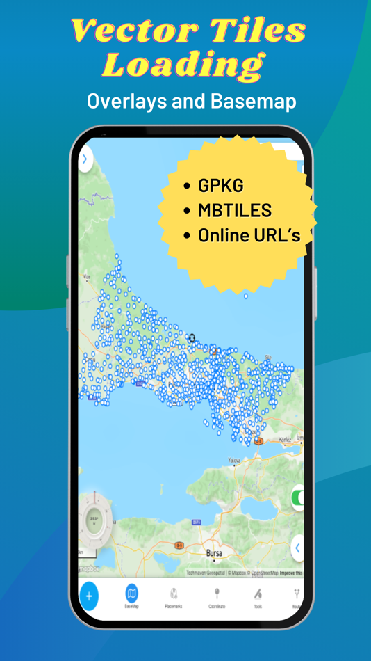
Supports user loaded device GeoJSON,Raster tiles from MBTILES and GPKG and vector tiles from MBTILES.
Supports user loaded Map Catalog (JSON) of internet mapping content (with catalog building screen)
XYZ PNG/JPG Raster Tiles
PBF Vector Tiles
GeoJSON
Local map tiles in mbtiles and gpkg
Includes additional layers users can enable:
vector overlays (Reference Grids, TimeZones and US State Boundaries)
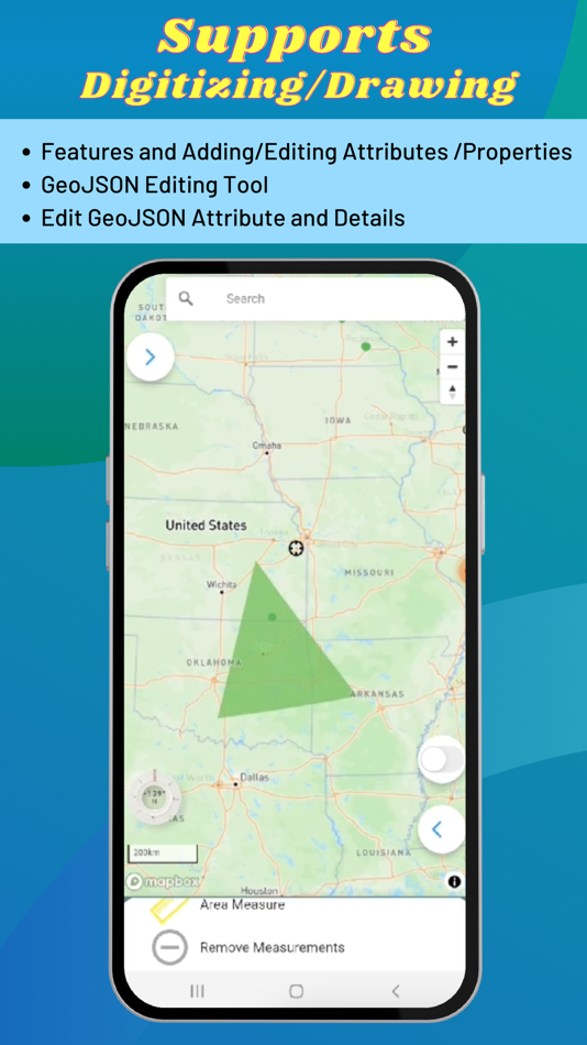
Draw/digitize vector data and support editing and assigning attributes.
Map Supports Tilting to display 3D terrain and 3D Buildings (only some basemaps support 3D buildings )
Currently, terrain is not available offline.
Map Tools:
- Search - places, addresses
- Advanced dynamic data collection forms with form builder
- Draw/Digitize Data Creation and Editing and export as GeoJSON
- Information Box for geojson data
- Measure linear and Area
- Geolocation & Coordinate Widget (Lat Long and MGRS and zoom level) and share location
- Go to Lat Long
- Placemarks (spatial bookmarks) (with import and export of Waypoints GeoJSON, KML and GPX)
- Basic Route Planning with import of Waypoints (KML and GPX)
- Connection to other Navigation Apps
- GPS Recorder with background recording and export or track
- View Spot Elevation
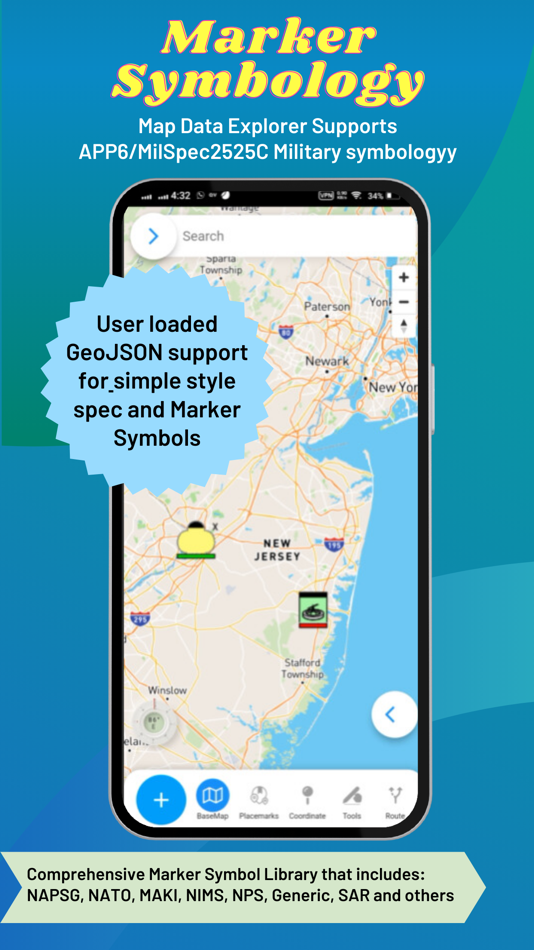
- Display Military Symbology (App6/MilSpec2525C) GeoJSON Schema easily shared with other apps
- Radius Ruler/Range Rings
- Coordinate Converter (to/from projected coordinates or geographic and GRIDS - MGRS, GARS, WHAT3WORD)
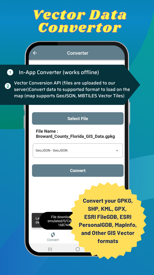
Includes an in-app vector converter to convert GIS data (Shapefiles, GPKG, GPX, KML, CSV, WKT to GeoJSON) must be 4326
Includes in-app coordinate converter to convert to /from different coordinate systems and GRIDS (MGRS,GARS, etc)
Wifi Sharing - access device files from web browser
File Manager To manage files
Create Forms with in-app or web form designer with JSON Schema
Load a form design and swap between forms
Collect any form data
Other features:
Vector Conversion and Publishing API to convert local vector GIS Data and also publish to PostGIS database tables.
Added Button links to TMG Map Data Explorer website for all in-app purchase screen
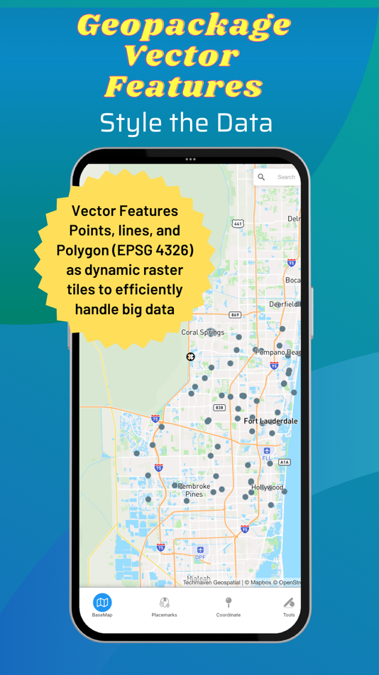
Serve OGC GPKG -GeoPackage with Vector Tiles new OGC extensions
Support for any SRS for raster tiles in GPKG (tested with 3857 and 3395)
Support for any SRS for Vector Tiles in GPKG (tested with 3857 and 3395)
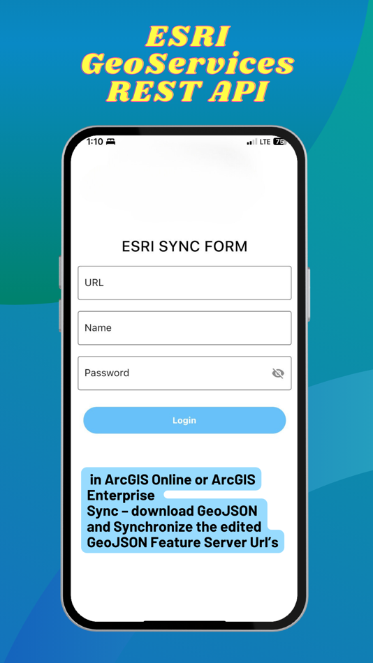
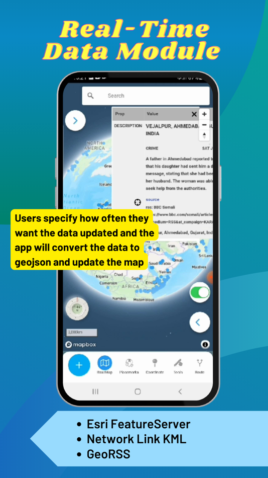
Real-Time Data Module (Network Link KML and Internet KML, ESRI GeoServices REST API and GeoRSS) display on the map and update at set frequency
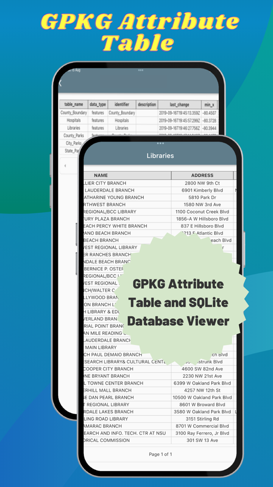
Button to view attributes from GPKG Vector Features
2nd Non Map View – Office documents (Word, Excel, Powerpoint), PDF Viewer, EPUB Viewer, User links web pages and File Manager
User loaded GeoJSON support for simple style spec and Marker Symbols
ESRI GeoServices REST API (FeatureServer) in ArcGIS Online or ArcGIS Enterprise Sync – download GeoJSON and Synchronize edited GeoJSON.
Elevate API - submit geojson point and return back with Elevation, MGRS, GARS, What3Words, PlaceKey, Pluscode properties
GeoRequest Area of Interest API for submitting jobs for offline data
Pre-staged data downloading of ready to download data
Area of interest downloading of online map data:
Tile Downloader that supports building mbtiles from tile layers (XYZ/TMS, WMTS and Dynamic and cached mapping services (ESRI MapServer, ImageServer, OGC WMS) and downloading GeoJSON from WFS and MapServer and FeatureServer.
Terms of Use: https://mapexplorer.techmaven.net/eula/
Screenshots


What's new
- Version: 1.3
- Updated:
- Numerous Bug Fixes and useability improvements
Added Button links to TMG Map Data Explorer website for all in-app purchase screen
OGC GPKG GeoPackage Vector Features as Dynamic PNG Raster Tiles with Symbology (labels coming in 1.3) and popups
Serve OGC GPKG -GeoPackage with Vector Tiles new OGC extensions
Support for any SRS for raster tiles in GPKG (tested with 3857 and 3395)
Support for any SRS for Vector Tiles in GPKG (tested with 3857 and 3395)
Real-Time Data Module (Network Link KML and Internet KML, ESRI GeoServices REST API and GeoRSS) display on the map and update at set frequency
Button to view attributes from GPKG Vector Features
2nd Non Map View – Office documents (Word, Excel, Powerpoint), PDF Viewer, EPUB Viewer, User links web pages and File Manager
User loaded GeoJSON support for simple style spec and Marker Symbols
ESRI GeoServices REST API (FeatureServer) in ArcGIS Online or ArcGIS Enterprise Sync – download GeoJSON and Synchronize edited GeoJSON.
Price
- Today: Free
- Minimum: Free
- Maximum: Free
Track prices
Developer
- Tech Maven GeoSpatial LLC
- Platforms: iOS Apps (9) Windows Apps (1)
- Lists: 0 + 0
- Points: 2 + 1 ¡
- Rankings: 0
- Reviews: 0
- Discounts: 0
- Videos: 0
- RSS: Subscribe
Points
Not found ☹️
Rankings
Not found ☹️
Lists
Not found ☹️
Reviews
Be the first to review!
Additional Information
- Category:
iOS Apps›Navigation - OS:
iPad,iPhone,iOS 14.0 and up - Size:
142 Mb - Supported Languages:
English - Content Rating:
4+ - App Store Rating:
0 - Updated:
- Release Date:
Contacts
- Website:
 https://mapexplorer.techmaven.net/
You may also like
-
- Terra Map - Trail Explorer
- iOS Apps: Navigation By: GEC s.r.l.
- * Free
- Lists: 0 + 0 Rankings: 0 Reviews: 0
- Points: 0 + 510 Version: 37.7 Enjoy every adventure safely with the best technology for outdoor navigation. Developed with the help of experienced hikers and bikers, Terra Map can meet all your needs. FEATURES: ...
-
- Offline Map Data Generator
- iOS Apps: Navigation By: Tech Maven GeoSpatial LLC
- Free
- Lists: 0 + 0 Rankings: 0 Reviews: 0
- Points: 0 + 0 Version: 1.0 Discover the Ultimate Mapping Experience with Tech Maven Geospatial Unleash the power of geospatial data with Tech Maven Geospatial, your all-in-one mapping solution available now on ...
-
- GPS-Explorer mobile
- iOS Apps: Navigation By: GPSoverIP GmbH
- Free
- Lists: 1 + 0 Rankings: 0 Reviews: 0
- Points: 11 + 1 Version: 4.29 You want to track your Vehicles or Objects to optimize your company processes? Then this is your App! With GPS-Explorer mobile for iOS (iPhone, iPad and iPod) the mighty GPS-Explorer ...
-
- Rack Explorer
- iOS Apps: Navigation By: Will Lin
- Free
- Lists: 0 + 0 Rankings: 0 Reviews: 0
- Points: 0 + 1 Version: 1.3.6 Rack Explorer has information on thousands of bike racks owned and maintained by Seattle Department of Transportation. Discover where the bike racks are near you or your destination! ...
-
- Trail Explorer
- iOS Apps: Navigation By: Evgueni Stoilkov
- Free
- Lists: 0 + 0 Rankings: 0 Reviews: 0
- Points: 0 + 0 Version: 1.2.3 Trail Explorer is a mobile platform to explore your environment, discover places of interest, chart untraveled itineraries, plan a trip to any map location, stay fit and have fun. Our ...
-
- Outdoor Explorer Utah - Map
- iOS Apps: Navigation By: GeoPOI LLC
- $1.99
- Lists: 0 + 0 Rankings: 0 Reviews: 0
- Points: 0 + 0 Version: 1.2.0 Utah is a geologic wonderland with an incredible amount of canyons, trails, and public land. About two-thirds of Utah is owned by the US Government or the State government and can be ...
-
- World Bike Map
- iOS Apps: Navigation By: Benjamin Collins
- * Free
- Lists: 0 + 0 Rankings: 0 Reviews: 0
- Points: 0 + 1 Version: 3.3.44 This is a bike map that guides you through urban and rural paths. Our worldwide bike map is designed to empower cyclists, ensuring safe journeys at every turn. See Your World ...
-
- SG BusTracker-Real-time Bus
- iOS Apps: Navigation By: 婧嘉 郭
- Free
- Lists: 0 + 0 Rankings: 0 Reviews: 0
- Points: 0 + 0 Version: 1.0.2 Key Features: Real-time Arrival Times: Quickly get estimated arrival times for the next and subsequent buses, ensuring you no longer have to endure long waits. Save Frequently Used Bus
-
- Waterway Guide
- iOS Apps: Navigation By: Waterway Guide
- * Free
- Lists: 0 + 0 Rankings: 0 Reviews: 0
- Points: 0 + 1,890 Version: 3.3 Optimized for your mobile devices with Waterway Guide's detailed and verified points of interest database. Includes over 1.3 million data points on marinas, anchorages, navigation ...
-
- ExplorOz Traveller
- iOS Apps: Navigation By: I.T. Beyond Pty Ltd
- * $39.99
- Lists: 0 + 0 Rankings: 0 Reviews: 0
- Points: 0 + 3 Version: 8.6.2 The premier travel planner and navigation tool for your ultimate Australian adventure. Whether you're planning a road trip, venturing off-road, or free camping in Australia's vast, ...