| Developer: | NEC Corporation (39) | ||
| Price: | Free | ||
| Rankings: | 0 | ||
| Reviews: | 0 Write a Review | ||
| Lists: | 0 + 0 | ||
| Points: | 0 + 16 ¡ | ||
| Points + 1 | |||
Description
")
●What is QZSS?
Quasi-Zenith Satellite System (QZSS) is a Japanese satellite positioning system composed mainly of satellites in quasi-zenith orbits (QZO).
Satellite positioning systems use satellite signals to calculate position information. One famous example is the American Global Positioning System (GPS) and the QZSS is sometimes called the Japanese GPS.
For details, please refer to the following Website "Quasi-Zenith Satellite System".
URL : https://qzss.go.jp/en
●What is GNSS View?
GNSS View provides that iOS version application that is based on the website application "GNSS View".
This application enables you to know position of positioning satellites such as QZSS and GPS in the specified time and location.
The positioning satellites displayed in the GNSS View are not based on the satellite information directly received by the smartphone but are displayed based on the satellite arrangement calculated based on the publicly released orbit information.
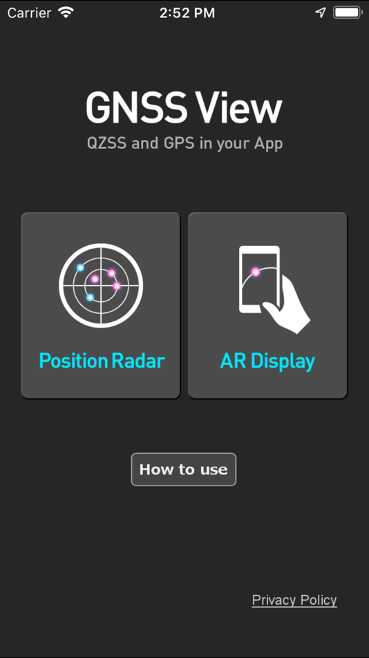
●GNSS View 3 functions
【Main】
・You can move to the Position Radar screen or AR Display screen from the application startup screen.
・You can see the operating manual and privacy policy of this application via the website.
【Position Radar】
・It is provided radar view of positioning satellites such as QZSS and GPS as a sky plot at the specified time and location.
・Positioning satellites can be specified from QZSS, GPS, GLONASS, BeiDou, Galileo, SBAS.
・You can also select specified signal satellites to see on the radar.
・You can see selected satellites by setting elevation mask angle.
・You can switch east and west of satellite arrangement, turn on / off rotation, and switch on / off display of satellite number.
・It displays HDOP, VDOP, the total number of satellites and the number of each positioning satellites in the satellite arrangement displayed on the radar.
【AR Display】
・Position of positioning satellites such as QZSS and GPS on the sky from your current location is able to see through your camera at the specified time.
・In order to display satellites, it is necessary to turn on the position information of the smartphone and complete the positioning. Therefore, it may take time to display.
・Positioning satellites can be specified from QZSS, GPS, GLONASS, BeiDou, Galileo, SBAS.
・You can also select specified signal satellites to see on the radar.
・You can see selected satellites by setting elevation mask angle.
●Supported versions
・iOS 17
・iOS 16
・iOS 15
・iOS 14
・iOS 13
・iOS 12
Screenshots


What's new
- Version: 5.0.2
- Updated:
- Now support iOS 17.
Price
- Today: Free
- Minimum: Free
- Maximum: Free
Track prices
Developer
- NEC Corporation
- Platforms: Android Apps (24) iOS Apps (15)
- Lists: 0 + 0
- Points: 0 + 843 ¡
- Rankings: 0
- Reviews: 0
- Discounts: 0
- Videos: 0
- RSS: Subscribe
Points
Not found ☹️
Rankings
Not found ☹️
Lists
Not found ☹️
Reviews
Be the first to review!
Additional Information
- Category:
iOS Apps›Navigation - OS:
iPad,iPhone,iOS 12.0 and up - Size:
4 Mb - Supported Languages:
English - Content Rating:
4+ - App Store Rating:
4.7(16) - Updated:
- Release Date:
You may also like
-
- Street View Map: Near by Tour
- iOS Apps: Navigation By: Kaneki Ken
- Free
- Lists: 0 + 0 Rankings: 0 Reviews: 0
- Points: 0 + 60 Version: 2.0.0 Street View Map Tour is an app that allows you to explore your surroundings in 360 degrees. It uses Apple's Look Around technology to provide street view for nearby places, so you can ...
-
- Street View Maps
- iOS Apps: Navigation By: Amit Lakhani
- Free
- Lists: 0 + 0 Rankings: 0 Reviews: 0
- Points: 0 + 11 Version: 1.6 3D Street View Allow you to find your location and show real time street panorama view with 3D Panorama 360 degree & Street Panorama View. Search world landmarks, discover natural ...
-
- Street View - Live 360 View
- iOS Apps: Navigation By: Sumit Kukadiya
- Free
- Lists: 0 + 0 Rankings: 0 Reviews: 0
- Points: 0 + 2 Version: 1.4 3D Street View Allow you to find your location and show real time street panorama view with 3D Panorama 360 degree & Street Panorama View. Live Satellite View GPS Map app gives the ...
-
- Street View 3D - 360° View
- iOS Apps: Navigation By: Nalin Savaliya
- Free
- Lists: 0 + 0 Rankings: 0 Reviews: 0
- Points: 0 + 18 Version: 2.1 Street View 3D - - 360° View allows you to find your location and show real time street panorama view with 3D Panorama , 360° View & Street Panorama View. Search world landmarks, ...
-
- Live Street View - Maps
- iOS Apps: Navigation By: BUSINESS SOLUTIONS INTERNATIONAL (PRIVATE) LIMITED
- Free
- Lists: 0 + 0 Rankings: 0 Reviews: 0
- Points: 0 + 3 Version: 1.1.13 Embark on a captivating journey of discovery with the Live Street View Map app. This revolutionary application revolutionizes the way you explore the world, offering an immersive and ...
-
- Street View Live 3D Maps
- iOS Apps: Navigation By: SV SOLITAIRE PRIVATE LIMITED
- Free
- Lists: 0 + 0 Rankings: 0 Reviews: 0
- Points: 0 + 2 Version: 1.0 Explore worldwide satellite imagery and 3D buildings and terrain for hundreds of cities. Zoom to your house or anywhere else, then dive in for a 360° perspective with Street View. 3D ...
-
- Eos Tools Pro
- iOS Apps: Navigation By: Eos Positioning Systems
- Free
- Lists: 0 + 0 Rankings: 0 Reviews: 0
- Points: 1 + 8 Version: 3.0 Eos Tools Pro is a monitoring utility for the Arrow Series High-Precision GPS/GNSS receivers from Eos Positioning Systems. It provides advanced GNSS information such as RMS values, ...
-
- MAPAS:Earth Live Street Maps
- iOS Apps: Navigation By: SOAD HAMADEH
- Free
- Lists: 0 + 0 Rankings: 0 Reviews: 0
- Points: 1 + 708 Version: 10.3 Embark on a journey like never before with Live Earth Maps your ultimate travel companion offering a 360° street view experience. Discover, explore, and navigate effortlessly through ...
-
- Rally Roadbook Reader
- iOS Apps: Navigation By: Rally Navigator, LLC
- Free
- Lists: 0 + 0 Rankings: 0 Reviews: 0
- Points: 0 + 3 Version: 3.1 View and Navigate Roadbooks from Rally Navigator. Imports PDF Roadbooks from Rally Navigator Desktop software (www.rallynavigator.com) to load and display Navigation Roadbooks. Rally ...
-
- Topo Maps
- iOS Apps: Navigation By: Mappendix Limited
- $7.99
- Lists: 0 + 0 Rankings: 0 Reviews: 0
- Points: 0 + 121 Version: 1.19 * View over 70,000 Natural Resources Canada 1:50,000 and USGS 1:24,000 topographical maps on your iPhone or iPod touch. * Ideal for hiking and other backcountry activities. * Map ...
-
- X-GPS Monitor
- iOS Apps: Navigation By: SquareGPS
- Free
- Lists: 0 + 0 Rankings: 0 Reviews: 0
- Points: 0 + 102 Version: 2.4.7 View your assets connected to GPS tracking platform using you iPhone and iPad: * Real time assets location on the map * Show tracks and events on the map for any period in the past * ...
-
- GT Buses
- iOS Apps: Navigation By: Alex Perez
- Free
- Lists: 0 + 0 Rankings: 0 Reviews: 0
- Points: 0 + 186 Version: 4.0.19 View up-to-date locations and time predictions for Georgia Tech Stinger buses and Tech Trolley. LIVE MAP Get up-to-date bus positions showing exactly where each bus is along its route.
-
- Travel Altimeter & Elevation
- iOS Apps: Navigation By: BranchenKing Ltd.
- Free
- Lists: 0 + 0 Rankings: 0 Reviews: 0
- Points: 0 + 37,624 Version: 5.6 View your altitude or elevation on stunning landscapes that adjust with the time of day. The barometer lets you track your altitude changes based on the change of pressure. Just set ...
-
- iMapGJ
- iOS Apps: Navigation By: City of Grand Junction
- Free
- Lists: 0 + 0 Rankings: 0 Reviews: 0
- Points: 0 + 3 Version: 2.0.4 View the City of Grand Junction GIS maps on your iPad, iPad mini, iPhone, or iPod Touch!