| Developer: | DataAppz, Inc. (5) | ||
| Price: | * Free | ||
| Rankings: | 0 | ||
| Reviews: | 0 Write a Review | ||
| Lists: | 0 + 0 | ||
| Points: | 0 + 53 ¡ | ||
| Points + 1 | |||
Description
")
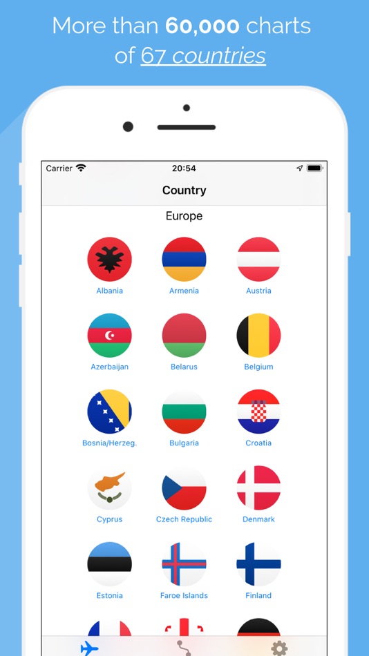
• 30,000 worldwide aerodromes
• 100,000 waypoints (United States and Brazil)
• 67 countries
AeroChart is an application designed for pilots and aviation enthusiasts. It is a pioneer in the segment. AeroChart is an aggregator and content organizer, focused on commercial aviation, which aids in navigation and allows the visualization of navigation charts. This app facilitates access of pilots to charts - formerly accomplished via PDF through generic readers . Adapted for mobile device access just getting more practical and organized.
REGIONS / SUBSCRIPTIONS (name, description with length of subscription)
• ASIA (Bangladesh, Hong Kong, India, Indonesia, Japan, Macau, Malaysia, Mongolia, Philippines, Singapore, South Korea, Taiwan and Thailand)
- Asia 1 month-Aero Charts Asia 1 month
- Asia 6 months-Aero Charts Asia 6 months
• BRAZIL
- Brazil 1 month-Aero Charts Brazil 1 month
- Brazil 1 month Plus-Aero Charts Brazil 1 month + GeoRef
- Brazil 6 months-Aero Charts Brazil 6 months
- Brazil 6 months Plus-Aero Charts Brazil 6 months + GeoRef
• EUROPE
- Europe 1 month-Aero Charts Europe 1 month
- Europe 1 month Plus-Aero Charts Europe 1 month + GeoRef
- Europe 6 months-Aero Charts Europe 6 months
- Europe 6 months Plus-Aero Charts Europe 6 months + GeoRef
• MIDDLE EAST(Bahrain, Cyprus, Jordan, Qatar, Saudi Arabia, Turkey and United Arab Emirates)
- MidEast 1 month-Aero Charts MidEast 1 month
- MidEast 6 months-Aero Charts MidEast 6 months
• OCEANIA (New Zealand only)
- Oceania 1 month-Aero Charts Oceania 1 month
- Oceania 6 months-Aero Charts Oceania 6 months
• RUSSIA (Russian Federation, Tajikistan and Turkmenistan)
- Russia 1 month-Aero Charts Russia 1 month
- Russia 6 months-Aero Charts Russia 6 months
• USA (UNITED STATES OF AMERICA)
- USA 1 month-Aero Charts USA 1 month
- USA 1 month Plus-Aero Charts USA 1 month + GeoRef
- USA 6 months-Aero Charts USA 6 months
- USA 6 months Plus-Aero Charts USA 6 months + GeoRef
ATTENTION: All the above subscriptions are also available in the [Premium] version. See conditions below.
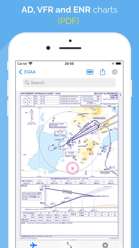
• Aero Charts means a limited time access package to the aeronautical charts (IFR, VFR and ENR) of the region informed of official and public Aeronautical Information Publications (AIP) with possibility of offline use and updates.
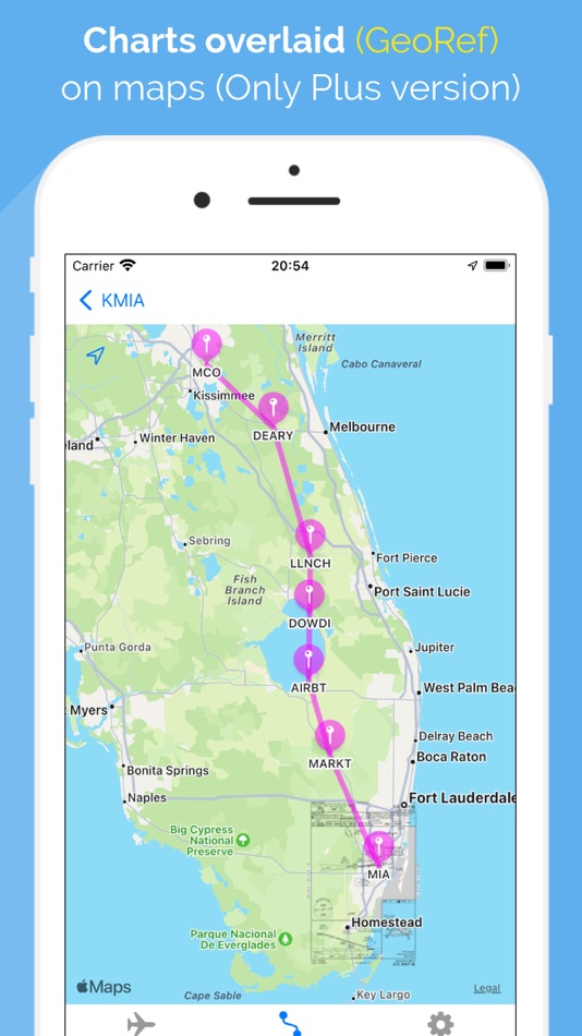
• GeoRef means providing the overlay capabilities of the aeronautical charts on the map integrated with the user's location. Available only on aeronautical charts provided by the publisher.
• [Premium] means a benefit granted to paying users of the Premium Version of previous applications with 50% discount on subscriptions and six months of evaluation period.
TERMS & CONDITIONS FOR AUTO-RENEWING SUBSCRIPTIONS:
• Payment will be charged to iTunes Account at confirmation of purchase
• Subscription automatically renews unless auto-renew is turned off at least 24-hours before the end of the current period
• Account will be charged for renewal within 24-hours prior to the end of the current period, and identify the cost of the renewal
• Subscriptions may be managed by the user and auto-renewal may be turned off by going to the user’s Account Settings after purchase
• Any unused portion of a free trial period, if offered, will be forfeited when the user purchases a subscription to that publication, where applicable.
TERMS OF USE AND PRIVACY POLICY
https://www.data-appz.com/terms_and_conditions.html
https://www.data-appz.com/privacy_policy.html
• Attention : This App should be used as an auxiliary tool in the planning phase of the flight to be conducted, not replacing the official documentation to be used by airmen during phases of flight.
• The content of the application is obtained from official and public Aeronautical Information Service (AIS) of each country. We are not responsible for the slowness, interruption or closure of services in a particular country and we will try to minimize this in the best way.
Screenshots
What's new
- Version: 3.0.2
- Updated:
- - Bug fixes and improvements.
If you have any questions, suggestions, complaints and bug reports please contact our support at: support@data-appz.com. Thanks!
Price
-
*In-App Purchases - Today: Free
- Minimum: Free
- Maximum: Free
Track prices
Developer
- DataAppz, Inc.
- Platforms: iOS Apps (2) macOS Apps (3)
- Lists: 0 + 0
- Points: 0 + 59 ¡
- Rankings: 0
- Reviews: 0
- Discounts: 0
- Videos: 0
- RSS: Subscribe
Points
Not found ☹️
Rankings
Not found ☹️
Lists
Not found ☹️
Reviews
Be the first to review!
Additional Information
- Category:
iOS Apps›Navigation - OS:
iPad,iPhone,iOS 15.5 and up - Size:
21 Mb - Supported Languages:
English - Content Rating:
4+ - App Store Rating:
4.4(53) - Updated:
- Release Date:
Contacts
You may also like
-
- Aero App
- iOS Apps: Navigation By: National Geospatial-Intelligence Agency
- Free
- Lists: 0 + 0 Rankings: 0 Reviews: 0
- Points: 1 + 37 Version: 1.2402.7840 The NGA Aeronautical Application (Aero App) is an Electronic Flight Bag (EFB) mobile application developed by and for the DOD and FAA flight crews. The Application provides flight ...
-
- NV Charts GPS Navigation AIS
- iOS Apps: Navigation By: NV Chart Group GmbH
- Free
- Lists: 0 + 0 Rankings: 0 Reviews: 0
- Points: 0 + 71 Version: 2.709.182 A clearly structured navigation app with intuitive and comprehensive tools for navigation on board. All current editions of the boating charts or maps from NV Verlag / NV Charts can be
-
- SkyDemon
- iOS Apps: Navigation By: Divelements Limited
- * Free
- Lists: 0 + 0 Rankings: 0 Reviews: 0
- Points: 0 + 492 Version: 3.16.13 SkyDemon is Europe's favourite software for VFR flight planning and in-flight navigation. Use this app to access your SkyDemon subscription on your iOS device, unlocking SkyDemon's ...
-
- WiseAero
- iOS Apps: Navigation By: Wiseapp LLC
- Free
- Lists: 0 + 0 Rankings: 0 Reviews: 0
- Points: 0 + 4 Version: 2.7.1 WiseAero: Your Premier Aviation Journey Partner Navigate the skies with ease and efficiency using WiseAero, the ultimate app for private jet operators and aviation professionals. ...
-
- Airmate
- iOS Apps: Navigation By: Myriel Aviation SA
- * Free
- Lists: 0 + 0 Rankings: 0 Reviews: 0
- Points: 1 + 423 Version: 3.15 Airmate is a free and easy to use flight planning and weather app for pilots, improving situational awareness and providing instant access to airport data and aviation maps, up to date
-
- Maptech iPlot
- iOS Apps: Navigation By: Nautical Solutions International, Inc.
- $39.99
- Lists: 0 + 0 Rankings: 0 Reviews: 0
- Points: 0 + 5 Version: 1.10.51 Maptech iPlot - Real Time Chart Plotting App The Maptech iPlot app is simple to use chart plotter app that utilizes many of the same routing functions that Maptech uses in their ...
-
- Imray Navigator
- iOS Apps: Navigation By: Imray
- Free
- Lists: 0 + 0 Rankings: 0 Reviews: 0
- Points: 0 + 7 Version: 2.5 Imray's marine chart plotter for sailors, divers, canoeists, fishermen and anyone involved with making way at sea. Nautical charts by Imray and other publishers Easy to use for passage
-
- savvy navvy: Boat Navigation
- iOS Apps: Navigation By: savvy navvy
- * Free
- Lists: 0 + 0 Rankings: 0 Reviews: 0
- Points: 0 + 5,323 Version: 2.2.11779 Everything you need to get out on the water, if you are a boater, sailor, paddleboarder, Jet skier, Kayaker or just going fishing, we ve got you covered. Free Features - All USA ...
-
- Sea Drive: Charts, Nav, Routes
- iOS Apps: Navigation By: Sea Drive, LLC
- * Free
- Lists: 0 + 0 Rankings: 0 Reviews: 0
- Points: 0 + 133 Version: 13.0.0 * What is Sea Drive? Sea Drive is a marine and boating application focused on charting, navigation, route building, track recording, tides, currents, and more! Our goal is to provide ...
-
- SafePilot by Trelleborg
- iOS Apps: Navigation By: Trelleborg Marine Systems Denmark A/S
- Free
- Lists: 0 + 0 Rankings: 0 Reviews: 0
- Points: 1 + 4 Version: 24.1 SafePilot is the new generation of professional maritime piloting software from Trelleborg. It is designed by a dedicated group of software developers and active maritime pilots. The ...
-
- eSeaGo
- iOS Apps: Navigation By: Hydrographic Office of Marine Department of the Government of HKSAR
- Free
- Lists: 0 + 0 Rankings: 0 Reviews: 0
- Points: 1 + 3 Version: 5.0.27 The "eSeaGo" is a free mobile application that offers a simple and convenient solution for displaying chart information for Hong Kong waters. Through the "eSeaGo", users can download ...
-
- iSailGPS : NOAA USA RNC Charts
- iOS Apps: Navigation By: James Associates Inc.
- $7.99
- Lists: 0 + 0 Rankings: 0 Reviews: 0
- Points: 0 + 63 Version: 9.4.5 Unleash the navigation potential of your iPhone or iPad with SailGPS! Turn your device into a high-performance GPS receiver with USA NOAA Raster Nautical Charts, even without a cell ...
-
- Navionics® Boating
- iOS Apps: Navigation By: Garmin Italy Technologies S.R.L.
- * Free
- Lists: 1 + 0 Rankings: 0 Reviews: 0
- Points: 1 + 1,806 Version: 21.0.3 Get up-to-date, detailed charts you can use offline plus a boatload of features on your mobile device, so they re on hand wherever you go. The Boating app is a must-have for cruising, ...
-
- iNavX: Marine Navigation
- iOS Apps: Navigation By: NavX Studios LLC
- * Free
- Lists: 0 + 0 Rankings: 0 Reviews: 0
- Points: 7 + 18,519 Version: 5.6.32 Marine navigation is made easy with iNavX - the world's #1 handheld Chartplotter. Access marine charts, maps, weather, AIS and more! iNavX is the only app to give you complete ...