| Developer: | Marco Palaferri (8) | ||
| Price: | $8.99 | ||
| Rankings: | 0 | ||
| Reviews: | 0 Write a Review | ||
| Lists: | 0 + 0 | ||
| Points: | 0 + 408 ¡ | ||
| Points + 1 | |||
Description
")
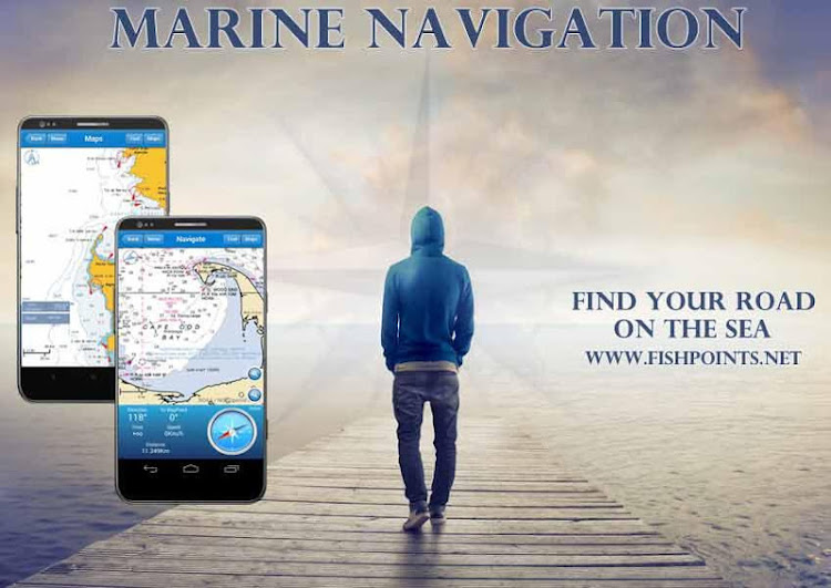
Find your road on the sea! GPS chartplotter for boating.
An easy-to-use offline GPS tracker and route planner featuring worldwide offline maps.
Buy once and for all, without any subscription
Navigate with your favorite device around the world, turn your smartphone or tablet into a GPS navigator with an offline map, ideal for sea, rivers and lakes, for boaters, fishermen and water sports.
This application is dedicated to the sea and the people who love it and live it with passion.
WHAT MAKES IT A BEST GPS TRACKER OR NAVIGATOR:
Offline GPS tracker for boat navigation. GPS Chartplotter for Sailing & boating.
Morse Code in case of danger, Anchor Alert to prevent the drift of the anchor, Moon Phase to show the phases of the moon during the day, Harbors to see the list of ports, Sync Waypoints to be able to create backups and access them from different devices.
You also get to download the maps and marine charts, so you won’t need an active internet connection when it comes to getting navigation and route planning. If you create a profile, you can save waypoints and routes to access them from different devices. All you have to do is logging in with the same account and enjoy seamless sea GPS navigations.
So, no matter you are a professional sailor or fisherman, or you are an amateur who like traveling in the sea, Marine Navigation has got you covered. It’s a versatile sea navigator app and boating route planner which provides accurate GPS Chartplotter and marine charts.
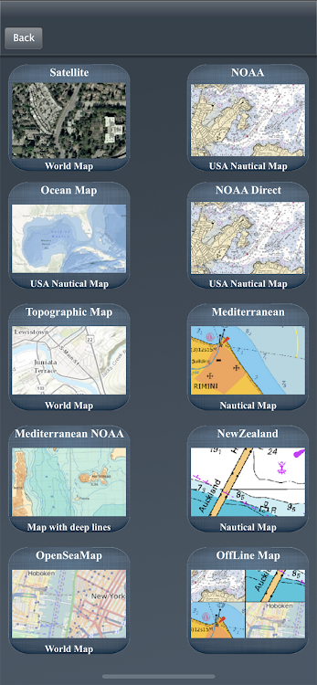
MAPS OFFLINE:
You can download maps or marine charts, you need a select area and application save tile into your device. You can navigate on preloaded maps or charts without connection.
MAPS AND MARINE CHARTS:
MapView: http://www.fishpoints.net/mapsview/
•Nautical maps of the United States of America by NOAA
•Nautical maps of the Mediterranean by NOAA
•Mediterranean RNC
•Nautical maps of the NewZealand by LINZ
•Maps of the world’s oceans and coastal areas by ESRI
•World topographic map includes boundaries, cities, water features, ports, physiographic features by ESRI
•Satellite imagery for the world by ESRI
•Maps for the sea, with ports, sea light and more by Open Sea Map
Marine Navigation: GPS Tracker Main Features at a Glance
•Super easy to use GPS tracker tool
•Clean and neat design
•Available in different languages: English, Italian, French, Spanish, Brazilian, Turkish and German,Indonesian
•Download Maps to use in offline mode
•Accurate and detailed GPS Chartplotter, GPS plotter and Marine charts
•Optimized for phones and tablets
•Sync routes and waypoints to access them anywhere from any devices
•Moon phase
•Morse Code
•Receive information about speed, direction, time to arrival
•Compass
•Change Measurement Units: Km, Mi, or Nmi
•Record your route for analyze the data and renavigate your trace
LOCATION PERMISSION
The app needs your location to trace the route on the map.
Location information is processed locally on your device, ensuring your privacy.
HELP US
Download Marine Navigation and let us know about any bugs, feature requests or any other suggestions. Stay tuned for more features and options in this GPS tracker app for boating.
WARNING
Good seamanship requires the use of official charts. Marine Navigation is for use with other charts and cannot replace official charts. Use at your own risk.
LEARN MORE ABOUT FISHPOINTS
http://www.fishpoints.net
A link to the terms of use: http://www.fishpoints.net/eula/
A link to the privacy policy: http://www.fishpoints.net/privacy-policy
Screenshots


Video
What's new
- Version: 8.5.00
- Updated:
Price
- Today: $8.99
- Minimum: $7.99
- Maximum: $23.99
Track prices
Developer
- Marco Palaferri
- Platforms: Android Apps (4) iOS Apps (4)
- Lists: 0 + 0
- Points: 1 + 2,765 ¡
- Rankings: 0
- Reviews: 0
- Discounts: 0
- Videos: 2
- RSS: Subscribe
Points
Not found ☹️
Rankings
Not found ☹️
Lists
Not found ☹️
Reviews
Be the first to review!
Additional Information
- Category:
Android Apps›Maps & Navigation - OS:
Android - Size:
33 Mb - Content Rating:
Everyone - Google Play Rating:
3.5(408) - Updated:
- Release Date:
Contacts
- Website:
 http://www.fishpoints.net
You may also like
-
- Marine Navigation Lite
- Android Apps: Maps & Navigation By: Marco Palaferri
- * Free
- Lists: 0 + 0 Rankings: 0 Reviews: 0
- Points: 0 + 2,354 Version: 8.4.27 MARINE NAVIGATION Find your road on the sea! GPS chartplotter for boating. An easy-to-use offline GPS tracker and route planner featuring worldwide offline maps. Navigate with your ...
-
- iNavX: Marine Navigation
- Android Apps: Maps & Navigation By: NavX Studios
- * Free
- Lists: 0 + 0 Rankings: 0 Reviews: 0
- Points: 0 + 751 Version: 1.6.4 Marine navigation is made easy with iNavX - the world's #1 handheld Chartplotter. Access marine charts, maps, weather, AIS and more! iNavX is the only app to give you complete ...
-
- Kadal Map - Marine Navigation
- Android Apps: Maps & Navigation By: Excel Technologies Nagercoil
- Free
- Lists: 0 + 0 Rankings: 0 Reviews: 0
- Points: 0 + 253 Version: 5.0 Simple Marine Navigation System, Helps fishing boats to record their fishing tracks and to find stones under sea. In-build AIS helps to find ships around your boat. Features: * Easy to
-
- Argo - Boating Navigation
- Android Apps: Maps & Navigation By: Argo Navigation, LLC
- * Free
- Lists: 0 + 0 Rankings: 0 Reviews: 0
- Points: 0 + 791 Version: 1.51.1 Argo™ is an easy-to-use navigation and social boating app FREE to download and FREE to use! Find and route to new destinations anywhere in North America, track your boat trips, see ...
-
- WinGPS™ Marine
- Android Apps: Maps & Navigation By: Stentec
- * Free
- Lists: 0 + 0 Rankings: 0 Reviews: 0
- Points: 0 + 1,193 Version: 4.66 WinGPS Marine offers you modern, easy to learn navigational tools for a safe trip. Long press on the chart to plot your route. The GPS on board will show your exact location. Download ...
-
- Wavve Boating: Marine Boat GPS
- Android Apps: Maps & Navigation By: Wavve Boating
- * Free
- Lists: 0 + 0 Rankings: 0 Reviews: 0
- Points: 0 + 1,249 Version: 4.7.4 When it comes to marine navigation, nautical charts, and boating maps, The Wavve Boating App is an easy choice. Wavve Boating improved outdated marine navigation apps, tide charts, and
-
- Polaris GPS Navigation
- Android Apps: Maps & Navigation By: Disciple Skies Software
- * * Free
- Lists: 0 + 0 Rankings: 0 Reviews: 0
- Points: 0 + 43,570 Version: 9.25 Easy-to-use high performance GPS for wherever your travels take you. No account setup or subscriptions required. Turn your phone into a powerful GPS navigation system with Polaris ...
-
- savvy navvy : Boat Navigation
- Android Apps: Maps & Navigation By: savvy navvy
- * Free
- Lists: 0 + 0 Rankings: 0 Reviews: 0
- Points: 0 + 2,030 Version: 2.2.11699 Everything you need to get out on the water, if you are a boater, sailor, paddleboarder, Jet skier, Kayaker or just going fishing, we ve got you covered. Free Features - All USA ...
-
- NV Charts GPS Navigation AIS
- Android Apps: Maps & Navigation By: NV CHARTS
- * Free
- Lists: 0 + 0 Rankings: 0 Reviews: 0
- Points: 0 + 1,783 Version: 2.714.192 The NV Charts navigation app with an intuitive interface and powerful tools is a must-have for onboard navigation while cruising, fishing, sailing, diving or any other activity on the ...
-
- Boat Beacon - AIS Navigation
- Android Apps: Maps & Navigation By: Electric Pocket
- * $14.99
- Lists: 0 + 0 Rankings: 0 Reviews: 0
- Points: 0 + 326 Version: 2.64 AIS receiver and display using just your Android device. Boat Beacon is the only Marine AIS ship tracking app to provide Collision Detection, use real-time data and share your own boat
-
- Ship Tracker: Boat Tracker
- Android Apps: Maps & Navigation By: Tracking Hub
- * * Free
- Lists: 1 + 0 Rankings: 0 Reviews: 0
- Points: 0 + 1,411 Version: 1.2.5 Are you looking for some ship mate for marine traffic, marine navigation or ship tracker to find ship? Are you an active captain and want to have marine traffic updates and a ship ...
-
- Aqua Map Boating
- Android Apps: Maps & Navigation By: GEC srl
- * Free
- Lists: 0 + 0 Rankings: 0 Reviews: 0
- Points: 0 + 663 Version: 26.8 Start Your 14-Day Free Trial on All Subscriptions Today Get the latest charts you can use offline, weather, tides and POIs from ActiveCaptain and Waterway Guide. Connect AIS and your ...
-
- Seapilot
- Android Apps: Maps & Navigation By: Seapilot
- * Free
- Lists: 0 + 0 Rankings: 0 Reviews: 0
- Points: 0 + 711 Version: 4.5.1 Professional marine navigation used to require an expensive GPS plotter. Now, same technology used in merchant shipping is available for your Android device. Use it to navigate, to ...
-
- Tides Planner
- Android Apps: Maps & Navigation By: Imray, Laurie, Norie and Wilson Ltd
- * Free
- Lists: 0 + 0 Rankings: 0 Reviews: 0
- Points: 0 + 181 Version: 1.170 Essential TIDES tool for sailors, divers, canoeists, fishermen, surfers, swimmers, photographers and anyone involved with sport or leisure at the seaside. At the push of a button Tides